Rangiroa (commune)

Last updated
Rangiroa
Passe d'Avatoru Rangiroa.jpg
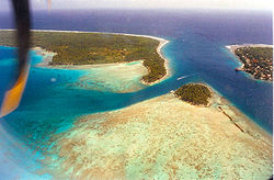
Avatoru Pass, atoll of Rangiroa
Flag of Rangiroa (municipality).gif
Localitzacion de Rangiroa en las Tuamotu.png
Location (in red) within the Tuamotu Archipelago
Location of Rangiroa
Rangiroa (commune)
Coordinates: 14°57′01″S147°39′04″W / 14.9504°S 147.6511°W / -14.9504; -147.6511
Country France
Overseas collectivity French Polynesia
Subdivision Îles Tuamotu-Gambier
Government
  Mayor (20212026) Tahuhu Maraeura [1]
Area
1
139 km2 (54 sq mi)
Population
 (2017)
3,657
  Density26/km2 (68/sq mi)
Time zone UTC−10:00
INSEE/Postal code
1 French Land Register data, which excludes lakes, ponds, glaciers > 1 km2 (0.386 sq mi or 247 acres) and river estuaries.

Rangiroa is a commune of French Polynesia in the archipelago of the Tuamotu Islands. The commune includes four islands: Rangiroa, Tikehau, Mataiva and Makatea. [2] The chef-lieu is the village Tiputa. [2]

Contents

Geography

Commune of Rangiroa

The commune is composed of three atolls and one island:

Atoll
or island
Main villagePopulation
2017 [3]
Area above water(km2) Lagoon
(km2)
Coordinates
Rangiroa 1 Avatoru 2,709791,446 15°07′S147°37′W / 15.117°S 147.617°W / -15.117; -147.617
Tikehau 1Tuherahera56020400 15°01′S148°10′W / 15.017°S 148.167°W / -15.017; -148.167
Mataiva 1Pahua2941625 14°53′S148°40′W / 14.883°S 148.667°W / -14.883; -148.667
Makatea 1Moumu9424- 15°51′S148°15′W / 15.850°S 148.250°W / -15.850; -148.250
Rangiroa
commune
Avatoru3,6571391,871

1 Commune associée

Administration

See also

Related Research Articles

<span class="mw-page-title-main">French Polynesia</span> Overseas French territory

French Polynesia is an overseas collectivity of France and its sole overseas country. It comprises 121 geographically dispersed islands and atolls stretching over more than 2,000 kilometres (1,200 mi) in the South Pacific Ocean. The total land area of French Polynesia is 3,521 square kilometres (1,359 sq mi), with a population of 278,786.

<span class="mw-page-title-main">Rangiroa</span> Atoll in French Polynesia

Rangiroa or Te Kokōta is the largest atoll in the Tuamotus and one of the largest in the world.

<span class="mw-page-title-main">Hao (French Polynesia)</span> Atoll in French Polynesia

Hao, or Haorangi, is a large coral atoll in the central part of the Tuamotu Archipelago. It has c. 1000 people living on 35 km2 (14 sq mi). It was used to house the military support base for the nuclear tests on Mururoa. Because of its shape, French explorer Louis Antoine de Bougainville named it "Île de la Harpe".

<span class="mw-page-title-main">Îles Tuamotu-Gambier</span>

The Îles Tuamotu-Gambier is an administrative division in French Polynesia. It consists of the Tuamotus and the Gambier Islands which are geographically located closely together.

<span class="mw-page-title-main">Rurutu</span> Island in French Polynesia

Rūrutu is the northernmost island in the Austral archipelago of French Polynesia, and the name of a commune consisting solely of that island. It is situated 572 km (355 mi) south of Tahiti. Its land area is 32.7 km2 (12.6 sq mi). It is 10.8 km long and 5.3 km wide. Its highest point (Manureva) is 389 m (1,276 ft). At the 2017 census it had a population of 2,466.

<span class="mw-page-title-main">Pirae</span> Commune in French Polynesia, France

Pīraʻe[pi.ra.e] is a commune in the suburbs of Papeʻete in French Polynesia, an overseas territory of France in the Pacific Ocean. Pīraʻe is located on the island of Tahiti, in the administrative subdivision of the Windward Islands, themselves part of the Society Islands. It borders Papeʻete in the west and Arue in the east. At the 2017 census it had a population of 14,209. The Stade Pater Te Hono Nui is a stadium located in the commune.

<span class="mw-page-title-main">Administrative divisions of French Polynesia</span> List of administrative divisions in France

In French Polynesia, there are two levels of administrative divisions: five administrative subdivisions and 48 communes. Many of the communes are further subdivided into communes associées. The breakdown into administrative subdivisions was as a result of the law #71-1028, dated December 24, 1971. The compositions of the administrative subdivisions and the communes were defined in the decrees #72-408 and #72-407 of May 17, 1972, respectively. These subdivisions were confirmed in the decree #2005-1611 of December 20, 2005. Below are several lists of the divisions, according to different sorting schemes.

<span class="mw-page-title-main">Teva I Uta</span> Commune in French Polynesia, France

Teva I Uta is a commune of French Polynesia, an overseas territory of France in the Pacific Ocean. The commune of Teva I Uta is located on the island of Tahiti, in the administrative subdivision of the Windward Islands, themselves part of the Society Islands. At the 2017 census it had a population of 10,254.

<span class="mw-page-title-main">Hitiaa O Te Ra</span> Commune in French Polynesia, France

Hitiaʻa O Te Ra is a commune of French Polynesia, an overseas territory of France in the Pacific Ocean. The commune of Hitiaʻa O Te Ra is located on the island of Tahiti, in the administrative subdivision of the Windward Islands, themselves part of the Society Islands. At the 2017 census it had a population of 10,033.

<span class="mw-page-title-main">Taiarapu-Est</span> Commune in French Polynesia, France

Taʻiarapu-Est is a commune of French Polynesia, an overseas territory of France in the Pacific Ocean. The commune of Taiʻarapu-Est is located on the island of Tahiti, in the administrative subdivision of the Windward Islands, themselves part of the Society Islands. At the 2017 census it had a population of 12,701.

<span class="mw-page-title-main">Taiarapu-Ouest</span> Commune in French Polynesia, France

Taiʻarapu-Ouest is a commune of French Polynesia, an overseas territory of France in the Pacific Ocean. The commune of Taiʻarapu-Ouest is located on the island of Tahiti, in the administrative subdivision of the Windward Islands, themselves part of the Society Islands. At the 2017 census it had a population of 8,078.

<span class="mw-page-title-main">Moorea-Maiao</span> Commune in French Polynesia, France

Moʻorea-Maiʻao is a commune of French Polynesia, an overseas territory of France in the Pacific Ocean. The commune is in the administrative subdivision of the Windward Islands. At the 2017 census it had a population of 17,816.

<span class="mw-page-title-main">Taputapuatea</span> Commune in French Polynesia, France

Taputapuatea is a commune of French Polynesia, an overseas territory of France in the Pacific Ocean. The commune of Taputapuatea is located on the island of Raiatea, in the administrative subdivision of the Leeward Islands, themselves part of the Society Islands. At the 2017 census it had a population of 4,792. The commune was named after a large marae complex which was the religious center of eastern Polynesia for roughly 1000 years. The archaeological site of Taputapuatea marae is still today the most famous landmark of Raiatea, and it was inscribed on the UNESCO World Heritage List in 2017.

<span class="mw-page-title-main">Maupiti (commune)</span> Commune in French Polynesia, France

Maupiti is a commune of French Polynesia, an overseas territory of France in the Pacific Ocean. The commune is in the administrative subdivision of the Leeward Islands.

<span class="mw-page-title-main">Arutua</span> Atoll in French Polynesia

Arutua, or Ngaru-atua is an atoll in the Tuamotu group in French Polynesia. It is located 40 km SW of Rangiroa. The closest land is Apataki Atoll, only 16 km to the East.

<span class="mw-page-title-main">Fakarava</span> Atoll in French Polynesia

Fakarava, Havaiki-te-araro, Havai'i or Farea is an atoll in the west of the Tuamotu group in French Polynesia. It is the second largest of the Tuamotu atolls. The nearest land is Toau, a coral atoll which lies 14 kilometres to the northwest.

<span class="mw-page-title-main">Nuku-Hiva</span> Commune in French Polynesia, France

Nuku-Hiva is a commune of French Polynesia, an overseas territory of France in the Pacific Ocean. The commune is in the administrative subdivision of the Marquesas Islands. Its population was 2,951 at the 2017 census.

The 1st constituency of French Polynesia is a French legislative constituency in French Polynesia.

<span class="mw-page-title-main">Gambier (commune)</span> Commune in French Polynesia, France

Gambier is a commune of French Polynesia in the administrative subdivision of the Tuamotu-Gambier Islands. The commune includes the Gambier Islands as well as several atolls in the Tuamotu Archipelago. All the Tuamotu atolls belonging to the commune are uninhabited except for Marutea Sud, and are sometimes mistakenly included among the Gambier Islands themselves. The commune population was 1,535 at the 2017 census. Its total land area is 45.97 km2.

French Polynesia's 2nd constituency is a French legislative constituency in French Polynesia. It is currently represented by Nicole Sanquer of A here ia Porinetia.

References

  1. "Répertoire national des élus: les maires". data.gouv.fr, Plateforme ouverte des données publiques françaises (in French). 9 August 2021.
  2. 1 2 Décret n°72-407 du 17 mai 1972 portant création de communes dans le territoire de la Polynésie française, Légifrance
  3. Répartition de la population en Polynésie française en 2017, Institut de la statistique de la Polynésie française