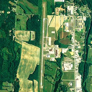
Northwest Missouri Regional Airport is a city-owned public use airport located two nautical miles (3.7 km) west of the central business district of Maryville, a city in Nodaway County, Missouri, United States. The airport is used for general aviation with no commercial airlines.
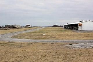
Lane Field is a privately owned, public use airport located two nautical miles (4 km) east of the central business district of Sanger, in Denton County, Texas, United States. The airport is used solely for general aviation purposes.
Bourland Field is a public airport located seventeen miles southwest of the central business district (CBD) of Fort Worth, in Parker County, Texas, United States. It was developed by Richard Bourland in September 1981 for whom the airport is named. In addition to serving as a public-use airport for southeastern Parker County, the airport also serves as an airpark for the attached housing development known as Bourland Field Estates.

Mefford Field is a public use airport in Tulare County, California, United States. It is owned by the City of Tulare and located three nautical miles (6 km) southeast of its central business district. This airport is included in the National Plan of Integrated Airport Systems for 2011–2015, which categorized it as a general aviation facility.

San Marcos Regional Airport is a public use airport located in Caldwell County, Texas, United States. It is four nautical miles (7 km) east of the central business district of San Marcos, a city that is mostly in Hays County. The airport is owned by the City of San Marcos and operated by Texas Aviation Partners. It is located east of the border of Caldwell County and Hays County. Before it was operated as a civilian airport it was known as Gary Air Force Base.
Rankin Airport is a privately owned, public-use airport located three miles (5 km) southeast of the central business district of Maryville, a city in Nodaway County, Missouri, United States.
Rankin Airport may refer to:
Skydive Houston Airport is a privately owned, private airport located in unincorporated Waller County, Texas, United States. It is four nautical miles (7 km) south of the central business district of Waller and is northwest of Houston. It was formerly known as Skylake Airport.
Dan Jones International Airport is a public-use airport in unincorporated Harris County, Texas, United States that is privately owned by Daniel Jones of Cypress. The airport is located 5 nautical miles (9 km) southwest of the city of Tomball and 22 nautical miles (41 km) northwest Houston.
Skyway Manor Airport is a public-use airport located three nautical miles west of the central business district of Pearland and in Brazoria County, Texas, United States. The airport is privately owned by Skyway Manor.
Memphis Municipal Airport is a city-owned public use airport located one nautical mile northeast of the central business district of Memphis, a city in Hall County, Texas, United States.

Tokeen Seaplane Base is a public use seaplane base located in Tokeen, in the Prince of Wales-Hyder Census Area in the U.S. state of Alaska.
Dallas South Port Airport is a privately owned public airport in Ferris, Ellis County, Texas, United States, that also serves the city Palmer, Texas, and is located approximately 3 nautical miles (5.6 km) north of the central business district. The airport has no IATA or ICAO designation.
Horseshoe Bend Airport is a privately owned public airport in Weatherford, Parker County, Texas, United States, located approximately 12 nautical miles (22 km) southwest of the central business district. The airport has no IATA or ICAO designation.
Lazy G Bar Ranch Airport is a privately owned public airport in Decatur, Wise County, Texas, United States, located approximately 5 nautical miles (9.3 km) northeast of the central business district. The airport has no IATA or ICAO designation.
Clark Airport is a privately owned public airport in Justin, Denton County, Texas, United States, located approximately 3 nautical miles (5.6 km) south of the central business district. The airport has no IATA or ICAO designation.
Bishop's Landing Airport is a privately owned public airport in Celina, Collin County, Texas, United States, located approximately 5 nautical miles (9.3 km) northeast of the central business district. The airport has no IATA or ICAO designation.
Ralph M. Hall/Rockwall Municipal Airport is a city-owned public airport 2 nautical miles (3.7 km) east of the central business district of Rockwall, Texas, United States. The airport has no IATA or ICAO designation.