
The Ottawa River is a river in the Canadian provinces of Ontario and Quebec. It is named in honour of the Algonquin word 'to trade', as it was the major trade route of Eastern Canada at the time. For most of its length, it defines the border between these two provinces. It is a major tributary of the St. Lawrence River and the longest river in Quebec.

Algonquin people are an Indigenous people of Eastern Canada. They speak the Algonquin language, a divergent dialect of the Ojibwe language, which is part of the Algonquian language family. Culturally and linguistically, they are closely related to the Odawa, Potawatomi, Ojibwe, and Oji-Cree, with whom they form the larger Anicinàpe (Anishinaabeg). The Algonquin people call themselves Omàmiwinini or the more generalised name of Anicinàpe.
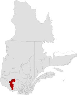
La Vallée-de-la-Gatineau(The Valley of the Gatineau) is a regional county municipality in the Outaouais region of western Quebec, Canada. The seat is in Gracefield. It was incorporated on January 1, 1983 and was named for its location straddling the Gatineau River north of Low.
Indigenous peoples in Quebec total 11 distinct ethnic groups. The 10 First Nations and the Inuit communities number 141,915 people and account for approximately 1.75% of the population of Quebec, Canada.

Kanehsatà:ke is a Mohawk settlement on the shore of the Lake of Two Mountains in southwestern Quebec, Canada, at the confluence of the Ottawa and Saint Lawrence rivers and about 48 kilometres (30 mi) west of Montreal. People who reside in Kanehsatà:ke are referred to as Kanehsata'kehró:non. As of 2014, the total registered population was 2400, with a total of about 1350 persons living on the territory. Both they and the Mohawks of the Kahnawà:ke reserve, located across from Montreal, also control and have hunting and fishing rights to Tiowéro:ton.

La Vérendrye wildlife reserve is one of the largest reserves in the province of Quebec, Canada, covering 12,589 square kilometres of contiguous land and lake area. It is named after Pierre Gaultier de Varennes, sieur de La Vérendrye, a French-Canadian explorer. Located 180 kilometres (110 mi) north of Ottawa, it is traversed from south to north by Route 117.
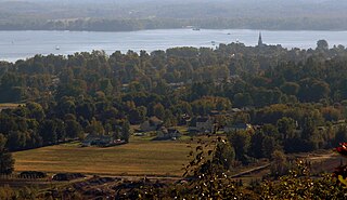
Oka is a small village on the northern bank of the Ottawa River, northwest of Montreal, Quebec, Canada. Located in the Lower Laurentians on Lake of Two Mountains, where the Ottawa has its confluence with the St. Lawrence River, the town has a main thoroughfare that is now part of Quebec Route 344. It's located 50 km northwest of Montreal.

The Dumoine River is a river in western Quebec with its source in Machin Lake near La Vérendrye Wildlife Reserve. From Dumoine Lake, the river flows almost due south off the Canadian Shield and empties into the Ottawa River, just west of Rapides-des-Joachims, Quebec, or Rolphton, Ontario. The river is 129 kilometres (80 mi) long and drains a watershed of 5,380 square kilometres (2,080 sq mi). This relatively short river compared to its drainage area indicates that the Dumoine has a strong current and many steep-gradient rapids.

Timiskaming is a First Nations reserve in the Abitibi-Témiscamingue region of Quebec, Canada, just north of the head of Lake Timiskaming. It belongs to the Timiskaming First Nation, an Algonquin band. It is geographically within the Témiscamingue Regional County Municipality but administratively not part of it.
The Ojibwe language is spoken in a series of dialects occupying adjacent territories, forming a language complex in which mutual intelligibility between adjacent dialects may be comparatively high but declines between some non-adjacent dialects. Mutual intelligibility between some non-adjacent dialects, notably Ottawa, Severn Ojibwe, and Algonquin, is low enough that they could be considered distinct languages. There is no single dialect that is considered the most prestigious or most prominent, and no standard writing system that covers all dialects. The relative autonomy of the regional dialects of Ojibwe is associated with an absence of linguistic or political unity among Ojibwe-speaking groups.
Wahgoshig First Nation, formerly known as Abitibi-Ontario Band of Abitibi Indians or simply as Abitibi, is an Anishinaabe and Cree First Nation band governments whose reserve communities are located near Matheson in Cochrane District in northeastern Ontario, Canada. They have reserved for themselves the 7,770.1 hectares Abitibi Indian Reserve No. 70 on the south end of Lake Abitibi. In January 2008, the First Nation had 270 people registered with the nation, of which their on-reserve population was 121.
Lac-Pythonga is an unorganized territory in the Outaouais region of Quebec, Canada. It surrounds Lake Pythonga and is the largest of the five unorganized territories in the La Vallée-de-la-Gatineau Regional County Municipality.

Kitigan Zibi is a First Nations reserve of the Kitigan Zibi Anishinabeg First Nation, an Algonquin band. It is situated near the confluence of the Désert and Gatineau Rivers, and borders south-west on the Town of Maniwaki in the Outaouais region of Quebec, Canada. Having a total area of 210 square kilometres (81 sq mi), it is the largest Algonquin Nation in Canada in both area and population.

The Cabonga Reservoir is a man-made lake in central Quebec, Canada, with a total surface area of 677 square kilometres (261 sq mi) and a net area of 484 square kilometres (187 sq mi). It is located on the boundary between the unorganized territories of Lac-Pythonga and Réservoir-Dozois, and fully within the La Vérendrye Wildlife Reserve. The First Nations reserve of Rapide Lake is on its western shores.

Obedjiwan is a First Nations reserve and village on the north shore of Gouin Reservoir in the Mauricie region of Quebec, Canada. It belongs to the Atikamekw of Opitciwan band of the Atikamekw Nation.

Coucoucache was a tiny First Nation reserve, in Cloutier Township, on the north shore of Reservoir Blanc on the Saint-Maurice River in the Mauricie region of Quebec, Canada. It belonged to the Atikamekw First Nation of Wemotaci but had no permanent population in recent decades.

Lac-John is a First Nations reserve on John Lake in the Côte-Nord region of Quebec, Canada, about 3.5 kilometres (2.2 mi) north-east from the centre of Schefferville. Together with the Matimekosh Reserve, it belongs to the Innu Nation of Matimekush-Lac John. It is geographically within the Caniapiscau Regional County Municipality but administratively not part of it.
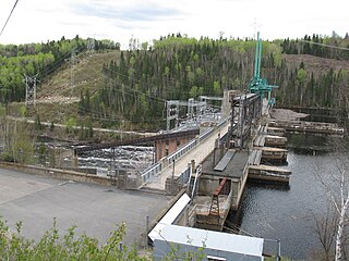
The Réservoir Blanc is a reservoir located in the city of La Tuque, in Quebec, Canada. The artificial lake was created in 1930 by the construction of the Rapide-Blanc Generating Station on Saint-Maurice River. The year 1996 marked the end of a period of 150 years of “drave” on the Saint-Maurice River; consequently the amateurs of recreation-touristic activities have appropriated the "Réservoir Blanc" mainly for boating and fishing. Around the reservoir and tributaries, a few hundred cottages are there and a few outfitters provide services to visitors.
Algonquins of Barriere Lake are an Algonquin First Nation in Quebec, Canada. They primarily live on the Indian reserve of Rapid Lake in Outaouais. In 2017 the band has a registered population of 792 members. It is part of Algonquin Nation Programs and Services Secretariat.
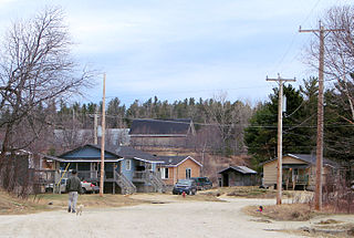
The Kitcisakik Anicinape Community, which the official name is communauté anicinape de Kitcisakik, is an Indian band of the Algonquin First Nations in Quebec, Canada. The majority of its members lives on the Indian settlement of Kitcisakik, also called Grand-Lac Victoria, located on the shore of the Grand lac Victoria on La Vérendrye Wildlife Reserve, where is also located the band council, the Conseil des Anicinapek de Kitcisakik. In 2017 the band had a registered population of 498 members.


