
Jhansi is a historic city in the Indian state of Uttar Pradesh. It lies in the region of Bundelkhand on the banks of the Pahuj River, in the extreme south of Uttar Pradesh. Jhansi is the administrative headquarters of Jhansi district and Jhansi division. Also called the Gateway to Bundelkhand, Jhansi is situated near and around the rivers Pahuj and Betwa at an average elevation of 285 m (935 ft). It is about 420 kilometres (261 mi) from New Delhi and 102 kilometres (63 mi)from Gwalior.

Chhatarpur is a city and a municipality in Chhatarpur district in the state of Madhya Pradesh, India. It is the administrative headquarters of Chhatarpur District.
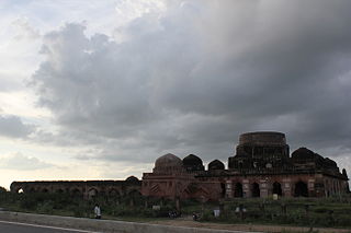
Kalpi is a Historical city and municipal board in Jalaun district in Uttar Pradesh, India. It is on the right bank of the Yamuna. Once Kalpi was more important Than Orai It is situated 78 kilometres south-west of Kanpur from which it is connected by both road and rail.

Orai is a city in Uttar Pradesh, India. It is the administrative headquarters of Jalaun District. All administrative offices of Jalaun District, including the District Collectorate, police, telecom and various other government organizations are located in this city. Orai received the award of 'Fastest Mover' Small City among India under Swachh Survekshan 2019, an annual cleanliness survey carried by Quality Council of India.

Bhander is a town and a nagar panchayat in Datia district in the state of Madhya Pradesh.
Chirgaon is a town and a municipal board in Jhansi district in the Indian state of Uttar Pradesh, India.
Karera is a municipality or Nagar Parishad in the Shivpuri district of the Indian state of Madhya Pradesh.
Gajner is a town located 37 kilometres from the city of Kanpur in the Kanpur Dehat district of the state of Uttar Pradesh, India. Gajner is located 11 kilometres from the district headquarters of Kanpur Dehat. Gajner is a connecting link of Kanpur, Ghatampur, Musanagar and Pukhrayan.
Ghatampur is a town and a municipal board in Kanpur Nagar district in the state of Uttar Pradesh, India.It is located near main industrial and educational hubs of the state Kanpur at a distance of 40 km.
Kanpur Dehat district is a district in Uttar Pradesh state in northern India. The administrative headquarters of the district are at Mati-Akbarpur. This district is part of Kanpur division. Kanpur was formerly spelled Cawnpore.

Bhaupur is a town in Kanpur Dehat district in the state of Uttar Pradesh, India.With World Bank funding development of Bhaupur Industrial Sector UPSIDC Amritsar-Kolkata dedicated freight corridor is being carried out.
Paman is a village in Kanpur Dehat district in the state of Uttar Pradesh, India.
Tilaunchi is a village in Kanpur Dehat district in the state of Uttar Pradesh, India.
Chaunrah is a village in Kanpur Dehat district in the state of Uttar Pradesh, India.
Ambiyapur is a village in Kanpur Dehat district in the state of Uttar Pradesh, India.
Binaur is a town in Kanpur district in the state of Uttar Pradesh, India.

Kanpur Bridge Left Bank is a small railway station in Shuklaganj, in the Unnao district of Uttar Pradesh, India. It lies on the Kanpur–Lucknow line. It comes after the Ganges bridge has been crossed. Only a few trains such as LKM [Lucknow–Kanpur MEMU], a type of local train halts for only 1 or 2 minutes or some Express train halts for some special reason or has to be given a pass.
Ait is a small town located in Jalaun district of Uttar Pradesh.
Amausi railway station is a local railway station in Lucknow, Uttar Pradesh. Its code is AMS. It serves lucknow city as well as the suburbs of lucknow. The station consists of three platforms.

Rasulpur is a village in Phillaur tehsil of Jalandhar District of Punjab State, India. The village is administrated by Sarpanch who is the elected representative of village and it is located 1.5 km away from Nagar, 8.6 km from census town Apra, 50 km from Jalandhar and 117 km from state capital Chandigarh. Rasulpur has postal head office in Phillaur which is 6.6 km away from the village.

