Ratcliff Lake Recreation Area

Last updated
Ratcliff Lake Recreation Area
Ratcliff Lake Recreation Area entrance portal.jpg
Entrance to Ratcliff Lake Recreation Area
Relief map of Texas.png
Red pog.svg
Location Houston County, Texas
Nearest city Kennard
Coordinates 31°23′19″N95°9′17″W / 31.38861°N 95.15472°W / 31.38861; -95.15472 Coordinates: 31°23′19″N95°9′17″W / 31.38861°N 95.15472°W / 31.38861; -95.15472
Established1936
Governing body United States Forest Service

Ratcliff Lake Recreation Area is a developed park within the Davy Crockett National Forest near Kennard, Texas, United States. The park surrounds a 45-acre lake that was once a mill pond and source of water for a sawmill which operated from 1902 to 1920. Ratcliff Lake Recreation Area was built in 1936 by the Civilian Conservation Corps (CCC) and is operated by the United States Forest Service (USFS). The facility is open year-round and includes a large campground, picnic areas, an amphitheater, a swim area and hiking trails. [1]

Davy Crockett National Forest

Davy Crockett National Forest is off U.S. Highway 69 lying west of Lufkin, Texas and east of Crockett. It is administered by the United States Department of Agriculture Forest Service local headquarters in Lufkin. There are local ranger district offices located in Ratcliff.

Kennard, Texas City in Texas, United States

Kennard is a city in Houston County, Texas, United States. The population was 337 at the 2010 census. The main street is Texas State Highway 7.

Sawmill facility where logs are cut into timber

A sawmill or lumber mill is a facility where logs are cut into lumber. Modern saw mills use a motorized saw to cut logs lengthwise to make long pieces, and crosswise to length depending on standard or custom sizes. The "portable" saw mill is iconic and of simple operation—the logs lay flat on a steel bed and the motorized saw cuts the log horizontally along the length of the bed, by the operator manually pushing the saw. The most basic kind of saw mill consists of a chainsaw and a customized jig, with similar horizontal operation.

Contents

History

In the late 19th century, pioneer settler J. H. Ratcliff operated a small sawmill in the virgin forests of East Texas. In 1899, the Central Coal and Coke Company of Kansas City, Missouri began buying land in the area along with the small sawmill. Central Coal and Coke eventually owned 120,000 acres of timberland. The company used Ratcliff's sawmill to produce materials to build the much larger "Four C Mill." By June 1902, the fourteen acre mill complex produced 350,000 board feet of lumber per day. By 1917, the company had cut all the larger old growth trees available. The company harvested the smaller trees between 1917 and 1920, but that could not keep the mill profitable and it ceased operation. [2]

East Texas cultural, geographic and ecological area in the US federated state of Texas

East Texas is a distinct cultural, geographic, and ecological area in the U.S. state of Texas.

Kansas City, Missouri City in western Missouri

Kansas City is the largest city in the U.S. state of Missouri. According to the U.S. Census Bureau, the city had an estimated population of 491,918 in 2018, making it the 38th most-populous city in the United States. It is the central city of the Kansas City metropolitan area, which straddles the Kansas–Missouri state line. Kansas City was founded in the 1830s as a Missouri River port at its confluence with the Kansas River coming in from the west. On June 1, 1850, the town of Kansas was incorporated; shortly after came the establishment of the Kansas Territory. Confusion between the two ensued and the name Kansas City was assigned to distinguish them soon after.

In October 1934, Civilian Conservation Corps Company 1803 set up camp in the area for project number F-4 to build Davy Crockett National Forest and Ratcliff Lake Recreation Area. The CCC built an earthen dam to turn the old sawmill pond into 45-acre Ratcliff Lake. They also built roads, a bath house and planted an estimated 3,000,000 trees to re-establish the forest.

Ratcliff Lake Recreation Area was closed in September 2008 due to damage from Hurricane Ike. After re-opening in 2010, damage caused by a tornado and then severe drought caused the park to close again between April 2011 and September 2012. [3]

Hurricane Ike Category 4 Atlantic hurricane in 2008

Hurricane Ike was a powerful tropical cyclone that swept through portions of the Greater Antilles and Northern America in September 2008, wreaking havoc on infrastructure and agriculture, particularly in Cuba and Texas. The ninth tropical storm, fifth hurricane, and third major hurricane of the 2008 Atlantic hurricane season, Ike developed from a tropical wave west of Cape Verde on September 1 and strengthened to a peak intensity as a Category 4 hurricane over the open waters of the central Atlantic on September 4 as it tracked westward. Several fluctuations in strength occurred before Ike made landfall on eastern Cuba on September 8. The hurricane weakened prior to continuing into the Gulf of Mexico, but increased its intensity by the time of its final landfall on Galveston, Texas on September 13, before becoming an extratropical storm on September 14. The remnants of Ike continued to track across the United States and into Canada, causing considerable damage inland, before dissipating on the next day.

Tornado Violently rotating column of air that is in contact with both the earths surface and a cumulonimbus cloud in the air

A tornado is a rapidly rotating column of air that is in contact with both the surface of the Earth and a cumulonimbus cloud or, in rare cases, the base of a cumulus cloud. The windstorm is often referred to as a twister, whirlwind or cyclone, although the word cyclone is used in meteorology to name a weather system with a low-pressure area in the center around which, from an observer looking down toward the surface of the earth, winds blow counterclockwise in the Northern Hemisphere and clockwise in the Southern. Tornadoes come in many shapes and sizes, and they are often visible in the form of a condensation funnel originating from the base of a cumulonimbus cloud, with a cloud of rotating debris and dust beneath it. Most tornadoes have wind speeds less than 110 miles per hour (180 km/h), are about 250 feet (80 m) across, and travel a few miles before dissipating. The most extreme tornadoes can attain wind speeds of more than 300 miles per hour (480 km/h), are more than two miles (3 km) in diameter, and stay on the ground for dozens of miles.

Drought extended period when a region notes a deficiency in its water supply

A drought or drouth is an event of prolonged shortages in the water supply, whether atmospheric, surface water or ground water. A drought can last for months or years, or may be declared after as few as 15 days. It can have a substantial impact on the ecosystem and agriculture of the affected region and harm to the local economy. Annual dry seasons in the tropics significantly increase the chances of a drought developing and subsequent bush fires. Periods of heat can significantly worsen drought conditions by hastening evaporation of water vapour.

Flora and fauna

The area is heavily forested with loblolly pine, oak and other hardwoods. A wide variety of wildlife inhabit the area, including the endangered red-cockaded woodpecker. The lake contains largemouth bass, bream, channel catfish and blue catfish [1]

Red-cockaded woodpecker species of bird

The red-cockaded woodpecker is a woodpecker found in southeastern North America. Some taxonomic authorities, including the American Ornithological Society, continue to place this species in the genus Picoides.

Largemouth bass species of fish

The largemouth bass is a carnivorous freshwater gamefish in the Centrarchidae (sunfish) family, a species of black bass native to the eastern and central United States and northern Mexico, but widely introduced elsewhere. It is known by a variety of regional names, such as the widemouth bass, bigmouth bass, black bass, bucketmouth, largies, Potter's fish, Florida bass, Florida largemouth, green bass, bucketmouth bass, Green trout, gilsdorf bass, Oswego bass, southern largemouth and (paradoxically) northern largemouth, LMB. The largemouth bass is the state fish of Georgia and Mississippi, and the state freshwater fish of Florida and Alabama.

Bream species of freshwater and marine fish

Bream ( ) is a species of freshwater and marine fish belonging to a variety of genera including Abramis, Acanthopagrus, Argyrops, Blicca, Brama, Chilotilapia, Etelis, Lepomis, Gymnocranius, Lethrinus, Nemipterus, Pharyngochromis, Rhabdosargus, or Scolopsis.

Related Research Articles

Houston County, Texas County in the United States

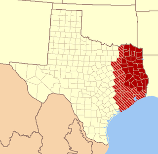
Houston County is a county located in the U.S. state of Texas. As of the 2010 census, the population was 23,732. Its county seat is Crockett. Houston County was one of forty-six prohibition or entirely dry counties in the state of Texas, until voters in a November 2007 special election legalized the sale of alcohol in the county.

Ratcliff, Texas Unincorporated community in Texas, United States

Ratcliff is an unincorporated community in Houston County in east Texas, United States.

Breakheart Reservation United States historic place

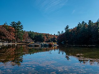
Breakheart Reservation is a public recreation area covering 652 acres (264 ha) in the towns of Saugus and Wakefield, Massachusetts. The reservation features a hardwood forest, two freshwater lakes, a winding stretch of the Saugus River, and scenic views of Boston and rural New England from rocky hilltops. The park is managed by the Massachusetts Department of Conservation and Recreation.

Sabine National Forest

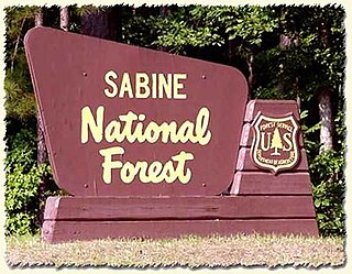
Sabine National Forest is located in East Texas near the Texas-Louisiana border. The forest is administered together with the other three United States National Forests and two National Grasslands located entirely in Texas, from common offices in Lufkin, Texas. There are local ranger district offices located in Hemphill.

Black Moshannon State Park

Black Moshannon State Park is a 3,481-acre (1,409 ha) Pennsylvania state park in Rush Township, Centre County, Pennsylvania, United States. It surrounds Black Moshannon Lake, formed by a dam on Black Moshannon Creek, which has given its name to the lake and park. The park is just west of the Allegheny Front, 9 miles (14 km) east of Philipsburg on Pennsylvania Route 504, and is largely surrounded by Moshannon State Forest. A bog in the park provides a habitat for diverse wildlife not common in other areas of the state, such as carnivorous plants, orchids, and species normally found farther north. As home to the "[l]argest reconstituted bog/wetland complex in Pennsylvania".

Laurel Hill State Park United States historic place

Laurel Hill State Park is a 3,935-acre (1,592 ha) Pennsylvania state park in Jefferson and Middlecreek Townships, Somerset County, Pennsylvania in the United States. Laurel Hill Lake is a 63-acre (25 ha) man-made lake with a dam that was constructed during the Great Depression by the young men of CCC camps SP-8-PA and SP-15-PA. Laurel Hill State Park is 8 miles (13 km) from Interstate 76 just off Pennsylvania Route 31 near Bakersville and on Pennsylvania Route 653 near Trent.

Pickett CCC Memorial State Park United States historic place

Pickett Civilian Conservation Corps Memorial State Park is a Tennessee state park in the upper Cumberland Mountains. It is located in Pickett County, northeast of the city of Jamestown, and is adjacent to the Big South Fork National River and Recreation Area. The park is located on 19,200 acres (78 km2) of wilderness including caves, natural bridges, and other rock formations. About 1,000 acres (4.0 km2) are managed by the Tennessee Department of Environment and Conservation as a state park, and the remainder of the property is managed by the Tennessee Division of Forestry as a state forest.

Bastrop State Park United States historic place

Bastrop State Park is a state park in Bastrop County in Central Texas. The park was established in 1938 and consists of stands of loblolly pines mixed with post oak and junipers.

Huntsville State Park

Huntsville State Park is a 2,083.2-acre (843 ha) wooded recreational area, six miles (10 km) southwest of Huntsville, Texas, within Walker County and the Sam Houston National Forest.

New Germany State Park Public recreation area in Garrett County, Maryland

New Germany State Park is a public recreation area covering 483 acres (195 ha) adjacent to Savage River State Forest in Garrett County, Maryland. The state park is administered by the Maryland Department of Natural Resources.

Spencer State Forest

Spencer State Forest is a Massachusetts state forest and recreation reserve located in the town of Spencer, managed by the Massachusetts Department of Conservation and Recreation. The 92 mile (148 km) Midstate Trail passes through the state forest. The Commonwealth of Massachusetts also conducts logging in some parts of the property.

Mission Tejas State Park

Mission Tejas State Park is a 660-acre (270 ha) state park located along Texas State Highway 21 in Houston County, Texas, originally constructed in 1935 and transferred to Texas Parks and Wildlife in 1957. The closest major town is Crockett, Texas. The park is open year-round.

Hopeville Pond State Park

Hopeville Pond State Park is a public recreation area located on Hopeville Pond, an impoundment of the Pachaug River, in the town of Griswold, Connecticut. A portion of the 554-acre (224 ha) state park occupies the site of the lost village of Hopeville. The park manager's house occupies Avery House, which is listed on the National Register of Historic Places. The park offers fishing, swimming, camping, and trails for hiking and biking. It is managed by the Connecticut Department of Energy and Environmental Protection.

Upton State Forest

Upton State Forest is a publicly owned forest with recreational features primarily located in the town of Upton, Massachusetts, with smaller sections in the towns of Hopkinton and Westborough. The state forest encompasses nearly 2,800 acres (1,100 ha) of publicly accessible lands and includes the last remaining Civilian Conservation Corps (CCC) camp in Massachusetts, built in National Park Service rustic style. The CCC campground was listed on the National Register of Historic Places in 2014.

Richard H. Keith (1842–1905), also known as R.H. Smith, was a coal and lumber businessman. He arrived in Kansas City, Missouri in 1871 with forty dollars and started a small coal yard. From that beginning evolved an empire spanning several states, that included coal, timber, sawmills, railroads, and even the building of towns.

Beeds Lake State Park United States historic place

Beeds Lake State Park is located northwest of Hampton, Iowa, United States. It was listed has a historic district on the National Register of Historic Places as Beeds Lake State Park, Civilian Conservation Corps Area in 1990. At the time of its nomination it contained 21 resources, which included one contributing building, 15 contributing structures, and five non-contributing structures. The 319-acre (129 ha) park surrounds a 99-acre (40 ha) reservoir. It features hiking trails, boating, fishing, swimming, camping, picnic areas and shelters, lodges and concessions.

Groton State Forest covers 26,164 acres (105.88 km2) in Danville, Groton, Marshfield, Orange, Peacham, Plainfield, Topsham, Vermont. The forest covers areas in Caledonia, Orange, and Washington Counties. Major roads through the forest are U.S. Route 302 and Vermont Route 232.

New Discovery State Park United States historic place

New Discovery State Park is a state park near Marshfield, Vermont in the United States. It is one of seven state parks located in Groton State Forest. The park is on Vermont Route 232, offering camping, picnicking, and access to forest trails. The park was developed in the 1930s by the Civilian Conservation Corps; its major CCC-built facilities, located mainly in western Peacham, were listed on the National Register of Historic Places in 2002.

Ricker Pond State Park United States historic place

Ricker Pond State Park is a state park in Groton, Vermont in the United States. It is one of seven state parks located in Groton State Forest. The park is just off Vermont Route 232. The park provides public access to Ricker Pond, a 95-acre (38 ha) lake in central Groton, and was developed in the 1930s by crews of the Civilian Conservation Corps. Activities includes camping, motor boating, waterskiing, fishing, swimming, paddling, horseback riding, hiking, mountain biking, snowshoeing and cross-country skiing. The park is open between the Memorial Day and Columbus Day weekends; fees are charged for day use and camping.

References

  1. 1 2 "Ratcliff Lake Recreation Area, TX". recreation.gov. Recreation.gov. Retrieved 11 April 2015.
  2. Eliza H. Bishop, "RATCLIFF, TX (HOUSTON COUNTY)," Handbook of Texas Online, accessed April 10, 2015. Uploaded on June 15, 2010. Published by the Texas State Historical Association.
  3. Johnson, Will. "Ratcliff Lake Recreation Area Re-Opens". The Messenger. Retrieved 11 April 2015.