
The Rome Metro is a rapid transit system that operates in Rome, Italy. It started operation in 1955, making it the oldest in the country.

Termini is an underground station of the Rome Metro. The station was inaugurated on 10 February 1955 as a station on Line B, and later became an interchange with Line A. The station is found in Piazza dei Cinquecento, under the Termini rail terminal. Together, the two stations form the main public transport hub in the city.

Cornelia is an underground station on Line A of the Rome Metro. It is located at the junction of Via di Boccea and the Circonvallazione Cornelia, from which it takes its name. The station was inaugurated on 1 January 2000.

Spagna is an underground station on Line A of the Rome Metro, in the rione Campo Marzio, which was inaugurated in 1980.
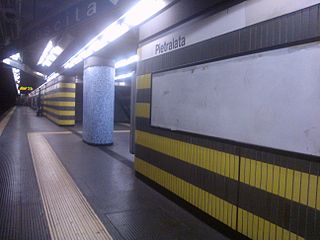
Pietralata is a station on Line B of the Rome Metro. It is located on Via di Pietralata, after which it is named, in the Pietralata quarter, the 21st quarter of Rome, near the Forte Tiburtino and the Autostrada A24.

Garbatella is a station on the Line B of the Rome Metro. It was opened in 1990 and is located behind the former Mercati Generali di Roma, on the via Ostiense in the Ostiense quarter. It replaces the old Garbatella station 200m away, whose entrance was on Piazza Giancarlo Vallauri.

Basilica San Paolo is a station on the Line B of the Rome Metro. It was opened in 1955 and is located at the intersection between Viale Giustiniano Imperatore and Via Gaspare Gozzi, behind the Basilica of Saint Paul Outside the Walls in the Ostiense quarter. It is also one of three Metro stations also served by the Rome-Lido railway line.
Ponte Lungo is a station on the Rome Metro. It is on Line A and is located in Appio Latino, between Re di Roma and Furio Camillo stations.

Numidio Quadrato is a station on the Rome Metro. It is on Line A and is located in the Quadraro district of Rome, under the intersection of Via Tuscolana and Via Scribonio Curione. The station is named after Via Numidio Quadrato, a nearby road whose name changed in 1980.

Metropolitan City of Rome Capital is an area of local government at the level of metropolitan city in the Lazio region of Italy. It comprises the territory of the city of Rome and 120 other comuni in the hinterland of the city. With more than 4.3 million inhabitants, it is the largest metropolitan city in Italy.

Monte Compatri-Pantano is the eastern terminus of Line C of the Rome Metro. It is located in Pantano, along the Via Casilina; thus being the only Roman Metro station outside the Rome municipality border.

Torre Spaccata is an underground station of Line C of the Rome Metro. It is located at the intersection of the Via Casilina with Via di Torre Spaccata and Via di Tor Tre Teste. The stop serves the areas of Torre Spaccata, Alessandrino and Tor Tre Teste. Construction of the station started in 2007, and it was opened on 9 November 2014.
Giardinetti is an underground station of Line C of the Rome Metro. It is located along the Via Casilina, at the intersection with Via degli Orafi and Via della Fattoria di Torrenova, in the Roman district of Giardinetti, near the Grande Raccordo Anulare. Construction of the station started in 2007 and it was opened on 9 November 2014. The homonymous terminus of the Rome–Giardinetti railway line was relocated within 500 metres from the Metro station.

Torrenova is a surface station of Line C of the Rome Metro. It is located in Via Casilina, serving the Roman districts of Torre Angela, Tor Vergata and Giardinetti. It's the only above-ground stop of Line C which retained the original architecture of the historic train station on the Rome–Pantano railway line. The old train station was temporarily closed down in 2008 for restoration and modernisation works; it re-opened on 9 November 2014 as part of the new Metro line.

Torre Angela is a station of Line C of the Rome Metro. It is located near Via Casilina, at the intersection of Viale Duilio Cambellotti and Largo Ettore Paratore. The station serves the Roman quarters Torre Angela, Tor Vergata and Tor Bella Monaca. The previous train station of the Rome–Pantano railway line closed in 2008 in order to be transformed into the current metro station. It was re-opened on 9 November 2014.

Grotte Celoni is a station of Line C of the Rome Metro. It is located along the Via Casilina in the Roman district of Grotte Celoni, but it also serves the districts of Tor Bella Monaca and Villaggio Breda. The previous train station of the Rome–Pantano railway line closed in 2008 as part of the renovation and modernisation programme; it was re-opened on 9 November 2014 as part of Line C.

Due Leoni-Fontana Candida is a station of Line C of the Rome Metro. It is located along the Via Casilina, on Via della Stazione Due Leoni. The previous train station of the Rome–Pantano railway line closed in 2008 and was totally rebuilt into the current Metro station; the stop was opened on 9 November 2014.

Borghesiana is a station of Line C of the Rome Metro. It is located between the Via Casilina and Via Biancavilla, in the Roman district of Borghesiana.
Finocchio is a station of Line C of the Rome Metro. It is located at the intersection of Via di Rocca Cencia with Via Mandanici and Piazza Serrule, in the Roman frazione of Borgata Finocchio.

Graniti is a station of Line C of Rome Metro. It is located at the intersection of Via Graniti with Via Tortorici, in the Roman frazione of Borgata Finocchio. It used to be a train station of the Rome-Pantano railway line until 2008, when rebuilding works commenced. With the inauguration of Line C, the stop re-opened on 9 November 2014. This station also serves the nearby depot of the line's rolling stock, and it extends over 21.7 hectares.

