Clear Creek is a tributary of the upper Sacramento River in northern California.
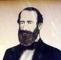
Pierson Barton Reading was a California pioneer.

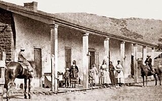
Rancho Buena Ventura was a 26,632-acre (107.78 km2) Mexican land grant in present-day Shasta County, California, given in 1844 by Governor Manuel Micheltorena to Major Pierson B. Reading (1816–1868). The land grant is named for the former name of the adjacent Sacramento River, Buena Ventura, which meant good fortune in Spanish. The grant extended some nineteen miles on the west side of the Sacramento River, from Cottonwood Creek on the south to Salt Creek on the north, and extended approximately three miles west of the Sacramento River the length of the grant. The grant encompassed present day towns of Anderson, Cottonwood and Redding. This was the northernmost land grant in California; the smaller Rancho Breisgau faced the southernmost portion of the Rancho on the east bank of the river and. Redding, however, was not named for Major Reading; it was named for B. B. Redding, a land agent for the Central Pacific Railroad.
Gas Point is a former unincorporated community and former ghost town in Shasta County, California, on Cottonwood Creek. It was also known as Pinckney and Janesville and started as a 1849 California Gold Rush Mining town after gold was found at Reading's Bar.

The Gates of Anaheim are a series of gates in California that mark the historic entrance to Anaheim, California. Four city gates were built: North, East, South, and West. They were designated a California Historic Landmark (No.122) on March 29, 1933.
Stone And Kelsey Home is a historical house in Kelseyville, California in Lake County. The house was built by Charles Stone and Andy Kelsey in 1849. Californios Salvador Vallejo (1813–1876), General Mariano Guadalupe Vallejo younger brother, sold the land to Charles Stone and Andy Kelsey. Charles Stone used forced Pomo tribe Native Americans labor to build their adobe house. Their home was the first adobe house in Lake County. Later the Indians killed both Stone and Kelsey in the fall of 1849, due to the resentment of forced labor and other cruel acts. Pomo tribesmen were also forced to labor in the nearby gold mines, including Kelsey Diggings. Later as reprisal there was the Bloody Island massacre by the U.S. Military. The site of the house is a California Historical Landmark No. 426. There is a Historical marker at the site of Charles Stone and Andy Kelsey Home, they are buried under the Historical marker.

Sheldon Grist Mill Site, is historical site in Sloughhouse, California in Sacramento County. The site is a California Historical Landmark No. 604 listed on June 2, 1949. The water powered gristmill, was used turn grain into flour, was on Rancho Omochumnes. The gristmill was built by Jared Dixon (Joaquin) Sheldon. Sheldon was grant then five square league of land on Rancho Omochumnes by the First Mexican Republic in 1843 by Mexican Governor Manuel Micheltorena as payment for carpenter work on the Monterey Custom House. Sheldon born on January 8, 1813, in Vermont and travelled to California 1832, working as a carpenter and millwright. Sheldon married Catherine Rhoads, the daughters of Thomas Rhoads in March 1847. Sheldon and his partner, William Daylor, also did some gold mining. Sheldon built a dam on Clark's Bar river on the his Sheldon Grant to irrigate the crops on his lands. The dam flood a California Gold Rush miners' claims. The angry miners' shot Sheldon on July 11, 1851. The conflict with Sheldon and the miners is called the Riot on the Cosumnes. In the conflict Sheldon was not the only one shot. Also Killed was James M. Johnson of Lancaster, Iowa and Edward Cody of Fox River, Illinois. Three were wounded: Calvin Dickerson of Berrien County, Michigan, Emanuel Bush of Des Moines County, Iowa and one unnamed miner. The Sheldon Grant was boarded on the south by the Cosumnes River and north by Deer Creek, 17 miles long between the rivers. The Sheldon Grist Mill was just west of the Sloughhouse Pioneer Cemetery, where Sheldon and his partner William Daylor and are buried. The site today is still mostly farmland.
Casa de Lopez was a historical Adobe building in San Diego, California built in 1835. The Casa de Lopez site is a California Historical Landmark No. 60, listed on December 6, 1932. Casa de Lopez, often called the long House, built by Juan Francisco Lopez, a Spanish settler of San Diego. Casa de Lopez was one of the first large houses built in San Diego. Juan Matias Moreno lived in the house starting in 1846. Juan Matias Moreno as the secretary to 10th Governor of Alta California, Governor Pío Pico, the last Mexican governor. The house, with a current address of 3890 Twiggs Street, is now a restaurant in Old Town, San Diego. A Historical marker is on corner of Twiggs Street west of Congress Street built by the California State Park Commission.

Fort Stockton, later called Fort Dupont was a historical fortress in San Diego, California built in 1828. The Fort Stockton site is a California Historical Landmark No. 54, listed on December 6, 1932.

San Diego Viejo Plaza,, also called Plaza de Las Armas, Old Town Plaza, Washington Square, is a historical site in San Diego, California. San Diego Viejo Plaza site is a California Historical Landmark No. 63, listed on December 5, 1932. The plaza was the center of Pueblo de San Diego founded in 1835 in Alta California.

Weber Point Home is a historical site in Stockton, California in San Joaquin County. The site of the former Weber Point Home is a California Historical Landmark No. 165, listed on January 11, 1935. The Weber Point Home was a built by Captain Charles M. Weber founder of Stockton. Weber was pioneer of California and built a two-story adobe-and-redwood house in 1850. At the time it was the largest house in Stockton. The house was built on the east end of the Stockton Channel. The house was surrounded by landscaped gardens built for his new wife Helen Murphy. Weber lived in the house till his death in 1881. The house was located on Center Street between Channel and Miner Street in Stockton. The Weber Point House was destroyed in a fire in 1917. The Weber Point House was the center of the 8,747 acre Mexican land grant Rancho Campo de los Franceses. The Rancho owned present day Stockton and lands south and east, most of the current San Joaquin County.

Bass Hill is a historical site in Redding, California in Shasta County. Bass Hill site is a California Historical Landmark No. 148 listed on January 11, 1935. On the top of Bass Hill the California and Oregon Stagecoach crossed the Pacific Highway and then dropped to the Pit River. The road, Old California-Oregon Road, on Bass Hill was popular bandit holdup spot. A historical Marker is on Bass Hill to Willianson Lyncoya Smith, division stage agent of the California and Oregon Stage Company and other drivers. Smith was pioneer stagecoach driver on the Bass Hill road. The Oregon Stage Line owned the California-Oregon Stagecoach Company for some years. The California and Oregon Coast Overland Mail, operated the California-Oregon Stagecoach Company Line. The California-Oregon Stagecoach Company had daily stage service with both mail and passengers. The California-Oregon Stagecoach Company also operated in the winter months with sleighs over Scott Mountains. California-Oregon Stagecoach Company had a line from Portland and Sacramento by 1860. In 1870, the California-Oregon Stagecoach Company changed its route, the new line ran from Shasta-Yreka Road through French Gulch to the Sacramento River Canyon route and bypassed Shasta. The California-Oregon Stagecoach Company ran operated until rail service replaced its routes in 1887.

Dersch Homestead is a historical site in Anderson, California in Shasta County. Dersch Homestead site is a California Historical Landmark No. 120 listed on March 31, 1933.

Fort Reading is a historical site in Anderson, California in Shasta County. Fort Reading site is a California Historical Landmark No. 379 listed on March 31, 1933. Founded on January 3, 1944, on west side of Cow Creek, Fort Reading was built to protect the settlers, California Gold Rush miners and travelers in the area. Fort Reading was founded by United States Army by Second Lieutenant E. N. Davis, Co. E, 2nd Infantry. Davis was sent to build the fort by Lieutenant Colonel George M. Wright. At the time the large fort was the first fort in Northern California. The fort was built in a 10 acres of land that had been cleared for good visibility. Fort Reading was named after Pierson Barton Reading. Most the larger base of troops were removed on April 1, 1856. The second draw down of troops was on June 13, 1867. The Fort Reading was completely abandoned on April 6, 1870. The Cow Creek would flood some years, flooding the fort sometimes. No trace of Fort Reading remains.

Catholic Basilica foundation is a historical site in Shasta, California in Shasta County. Catholic Basilica site is a California Historical Landmark No. 483 listed on April 10, 1951. The cornerstone of Catholic Basilica was place in May 1857 by Archbishop Joseph Sadoc Alemany O.P. and the Reverend Raphael Rinaldi. The church had its begianing in 1853, when the Archbishop of San Francisco, Alemany, sent Father Florian Schwenninger to be the head of mission in Shasta County serving the miners and settlers. The first church was small wooden church built in 1853. In 1855 Father Schwenninger was transferred to Weaverville and Father Raphael Rinaldi took of duties at Shasta. Father Rinaldi started to built the new stone church in 1857, to replace the wooden church. The building did not get beyond the laying of the Foundation, that is still on the site.
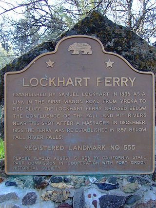
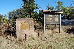
Lockhart Ferry foundation is a historical site in Fall River Mills, California in Shasta County. Lockhart Ferry site is a California Historical Landmark No. 555 listed on July 31, 1956. In 1856 Samuel Lockhart built a road and ferry, it was the first wagon trail road from the City of Yreka to the City of Red Bluff. To cross the Fall River Lockhart built a cable ferry across the river, just about the Pit River. Due to a native tribes attacks in the eara in December 1856, the ferry was moved down stream below Fall River Falls in 1857.
Old California Oregon Road is a historical site in Anderson, California, in Shasta County. Old California Oregon Road site is California Historical Landmark No. 58 listed on December 6, 1932. The Old California Oregon Road was the main road used by pioneer travelers between the Trinity River and the northern gold mines of California and Oregon. The main part of the Old California Oregon Road ran from Portland to Sacramento.
Pioneer Baby's Grave is a historical site in Redding, California in Shasta County. Pioneer Baby's Grave is a California Historical Landmark No. 377 listed on July 28, 1942. George and Helena Cohn Brownstein lived in Red Bluff. There infant son, 8-month-old, Charles Brownstein died on December 14, 1864. As there was Jewish cemetery in Red Bluff, George and Helena traveled 40 miles in two-days by covered wagon to a Jewish cemetery founded in 1857 by the Shasta Hebrew Congregation, Shasta Hebrew Benevolent Society. Charles was interred in Shasta Hebrew Congregation's Jewish cemetery, the first one found in the region. When California State Route 299 was built in 1923, the plans route the highway as to not disturb the grave. The Jewish cemetery was neglected for some years, till in 1976 when the Redding Jewish Community Center was founded. The site is now cared for by the Jewish Community Center.

Reading's Bar is a historical site in Reading, California in Shasta County. Reading's Bar is a California Historical Landmark No. 32 listed on August 1, 1932. Reading's Bar is gold find site and was named after Major Pierson Barton Reading. Reading discovered gold on the Clear Creek bar in May 1848, starting a California Gold Rush in the surrounding area. Later he found gold on a sandbar on the Trinity River that stated the Trinity Alps Gold Rush. Reading gold discovery was a major part of the California Gold Rush and news of the find started the Northern California 49ers Gold Rush. Reading started to look for gold soon after hearing about the Sutter's Mill gold discovery. Reading worked as John Sutter’s clerk and trapper in 1844.
Because of the Reading's Bar gold discovery a number of small mining towns grew up on and north of the Clear Creek including: Horsetown, Briggsville, Muletown, Lower Springs, Texas Springs, Middletown, Piety Hill, Igo, Larkin, Jackass Flat, Ono, Bald Hills, Janesville, and to the north Whiskeytown, Shasta, Tower House, and French Gulch.