
Karimnagar district is one of the 33 districts of the Indian state of Telangana. Karimnagar city is its administrative headquarters. The district shares boundaries with Peddapalli, Jagityal, Sircilla, Siddipet, Jangaon, Hanamkonda district and Jayashankar Bhupalapally districts.

Medak district is a district located in the Indian state of Telangana. Medak is the district headquarters. The district shares boundaries with Sangareddy, Kamareddy, Siddipet and Medchal districts.
Madhira is a municipality situated in the Khammam district of the Indian state of Telangana, falling within the Madhira Assembly Constituency. This area is located in the Madhira mandal of Khammam division and is positioned approximately 230 kilometers east of the state capital, Hyderabad. Additionally, it is situated 53 kilometers from the district headquarters Khammam and is bordered by Andhra Pradesh state on three sides.

Suryapet is a city in the Indian state of Telangana. It is a municipality and the headquarters of its eponymous district. The Government of India announced Suryapet to be developed under the Atal Mission for Rejuvenation and Urban Transformation (AMRUT) scheme. Suryapet has been awarded the "Cleanest city" in South India by the Ministry of Urban development in Swachh Survekshan 2017. It is also known as "Gateway of Telangana". It is located about 134 kilometres (83 mi) east of the state capital, Hyderabad and also it is located about 138 kilometres (86 mi) West of Vijayawada.

Siddipet is a city in the Indian state of Telangana. It is a municipality and serves as the headquarters of Siddipet district. It is located about 100 kilometres (62 mi) north of the state capital, Hyderabad, and 92 kilometres (57 mi) from Warangal. The District Headquarters and police Commissionerate is located at Siddipet City.
Jangaon (Janagama) is a town and the district headquarters of Jangaon district in the Indian state of Telangana. It is also the mandal and divisional headquarters of Jangaon Mandal and Jangaon revenue division respectively. It is about 85 kilometres (53 mi) from the state capital Hyderabad. It lies on the National Highway 163

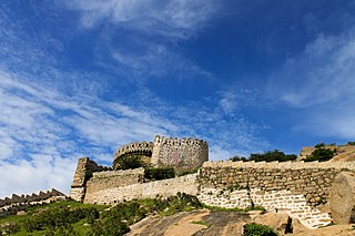
Sircilla is a town and the district headquarters of Rajanna Sircilla district in the Indian state of Telangana. It is located on the banks of Manair river in the Sircilla mandal of Sircilla revenue division. It is popularly known as Textile Town due to the presence of large number of power looms, textile processing and dyeing units. It is the biggest textile hub in the state of Telangana with over 40,000 power looms. Sircilla, along with Warangal is proposed to be developed as a mega textile zone by the Telangana government. The first Visalandhra Mahasabha in Telangana was held at Sircilla during the Visalandhra movement.
Janpahad, or Janapahad, is a small village in Palakeedu Mandal, Suryapet District, Telangana, India. It is located near state border with Andhra Pradesh, about 7 kilometres southeast of the mandal headquarters Palakeedu, and 45 kilometres south of the district headquarter Suryapet. As of the year 2010, it has a total population of 3,979.
Pullur is a village in Siddipet District in the state of Telangana, India.

Ramayampet is a Municipality and a mandal in Medak District of Telangana State. Ramayampet was an Assembly Constituency in the former Andhra Pradesh State from 1952 to 2009 in Medak district in Indian state of Telangana. It is the 4th biggest town in Medak district and is 20 km form Medak and is 80 km (50 mi) from Hyderabad. Located on National Highway NH 44, The longest National Highway in India NH 44 in Ramayampet.
Bakri Chepyal, is a gram panchayat (village) under Siddipet mandal, Siddipet district, Telangana, India. As of the 2001 census, the population was around 2000.
Konaipalle is a village in the siddipet district of Telangana, India. It falls under the Nangnur mandal. It is located 12.5 km distance from its constituency Siddipet. Konaipalle comes under Medak district before formation of new districts in telangana. Presently konaipalle belongs to siddipet district. The famous Lord Venkateshwara temple located here. Kalvakuntla chandrasheker rao usually offer prayers before every nomination from his first elections since 1985. It became a tradition for him. Thaneeru Harish Rao also do the same. The temple was constructed in 1980s by the devotees. The present temple was a renovated one during 2020s with a cost of 3.5 crores. Usually in the february, 3 days fair will be conducted by devotees. On the very first day, Lord venkateshwara swamy kalyanam will be conducted, On second and third day, Annadanam(Food donation), Edla uregimpu will be conducted respectively.

Kamareddy district is a district located in the northern region of the Indian state of Telangana. The district shares boundaries with Medak, Nizamabad, Sangareddy, Siddipet and Rajanna Sircilla districts and with the state boundary of Maharashtra and Karnataka.

Siddipet district is a district located in the northern region of the Indian state of Telangana. Its headquarters is Siddipet. This district contains a part of the Hyderabad Metropolitan Region(Markook Mulugu Wargal) The district shares boundaries with Jangaon, Sircilla, Karimnagar, Kamareddy, Hanamkonda, Yadadri, Medhchal and Medak districts.
Yadadri Bhuvanagiri District, is a district in the Indian state of Telangana. The administrative headquarters is located at Bhuvanagiri Town. The district shares boundaries with Suryapet, Nalgonda, Jangaon, Siddipet, Medchal-Malkajgiri and Rangareddy districts. It was carved out of Nalgonda district on 11 October 2016 during a large reorganization of the districts of Telangana.

Medchal−Malkajgiri district is a district in the Indian state of Telangana. Shamirpet is the headquarter of the district. It is the second most populous district with a population of 25 lakh and also 91.40% urbanized district in the state of Telangana, standing next only to Hyderabad district which has a population of 40 lakhs. The district shares boundaries with Hyderabad, Medak, Sangareddy, Y. Bhuvanagiri, Siddipet and Rangareddy districts.The most part of the district consist of Hyderabad City (GHMC)

Jangaon district is a district in the Indian state of Telangana. It was a part of the erstwhile Warangal district prior to the re-organisation of districts in the state. The district shares boundaries with Suryapet, Yadadri, Warangal, Hanamkonda, Siddipet and Mahabubabad districts.
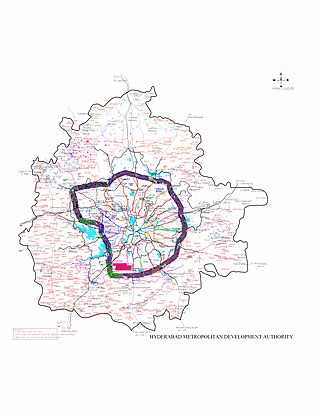
Hyderabad Metropolitan Region is the metropolitan area covered by the city of Hyderabad in the Indian state of Telangana. The entire region is spread over the districts of Hyderabad District, Bhuvanagiri, Medchal-Malkajgiri, Ranga Reddy, Sangareddy, Medak, and Siddipet. Under the jurisdiction of Hyderabad Metropolitan Development Authority, it covers an area of 7,257 km2 (2,802 sq mi) and has a population of 10.7 million people.

Kothapalli (Haveli) (Telugu: కొత్తపల్లి), or Kothapalli, is a Revenue Village and a semi-town in Kothapalli Mandal, Karimnagar district, Telangana, India. The village used to be in the Karimnagar mandal of the old Karimnagar district. Following the district reorganization of Telangana, it was included in the newly formed Kothapalli Mandal. Kothapalli was formed as a municipal corporation on 2 August 2018, as part of the Municipal Amendment Bill by the Government of Telangana.
Bethampudi is a village in Tekulapalli Mandal, Bhadradri Kothagudem District, Telangana, India. It is located near the boundary with Khammam District, approximately 12 kilometres west of the district seat Kothagudem, and 6 kilometres northeast of the mandal seat Tekulapalli. In 2011, the village has a total population of 25,461.

