
Porirua, a city in the Wellington Region of the North Island of New Zealand, is one of the four cities that constitute the Wellington metropolitan area. The name 'Porirua' is a corruption of 'Pari-rua', meaning "the tide sweeping up both reaches". It almost completely surrounds Porirua Harbour at the southern end of the Kāpiti Coast. As of 2023, Porirua has a population of 62,400 people, and is a diverse city with 26.5% of the population identifying as Pasifika and 23.0% of the population identifying as Māori.
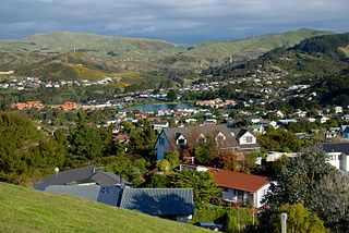
Whitby, a large suburb of Porirua City, New Zealand, located along much of the southern shore of the Pauatahanui Inlet of Porirua Harbour was comprehensively planned in the 1960s and it has been continuously developed since, with current landscaping and expansion in the hills behind the eastern part of Whitby to facilitate the future growth of the suburb.

Tawa is the northernmost suburb within the Wellington city boundary, located roughly 15 km north of Wellington's CBD between Churton Park and Porirua in the North Island of New Zealand. It takes its name from the broadleaf tree, which was once prolific throughout the area, although its most famous tree is the Bucket Tree, a large macrocarpa with the topiary of an upside-down bucket. Tawa is also known for its large number of churches, representing a wide range of Christian denominations.

Khandallah is a suburb of Wellington, the capital city of New Zealand. It is located 4 kilometres (2.5 mi) northeast of the city centre, on hills overlooking Wellington Harbour.

The 8.38 miles (13.49 km) Tawa Flat deviation is a double-track section of the Kapiti Line just north of Wellington, New Zealand with two tunnels; the southernmost section of the North Island Main Trunk railway (NIMT) between Wellington and Auckland. It was built to bypass a limited capacity single track section of the original Wellington and Manawatu Railway (WMR) line which ascended from Wellington to Johnsonville and then descended to Tawa Flat. The original name of Tawa Flat was changed to Tawa in 1959.

Metlink's Kapiti Line is the electrified southern portion of the North Island Main Trunk railway between New Zealand's capital city, Wellington, and Waikanae on the Kāpiti Coast, operated by Transdev Wellington on behalf of Greater Wellington Regional Council. Trains run frequently every day, with stops at 16 stations. Until 20 February 2011 it was known as the Paraparaumu Line.

The Johnsonville Branch, also known as the Johnsonville Line, is a commuter branch line railway from the main Railway Station of Wellington, New Zealand to the northern suburb of Johnsonville via Ngaio and Khandallah.

The Johnsonville–Porirua Motorway is a motorway in Wellington, New Zealand. The majority of the motorway forms part of State Highway 1, the main route of traffic in and out of the city, with the northernmost 2.1 km (1.3 mi), formerly part of SH 1 until 7 December 2021, designated as State Highway 59. Completed in the 1950s, it was New Zealand's first motorway.
Takapu Road railway station is on the suburban rail network of Wellington, New Zealand, on the Kapiti section of the North Island Main Trunk Railway (NIMT). It is double tracked with side platforms. It serves the suburbs of Redwood and Grenada North, and the rural Takapu Valley.

Redwood railway station on the suburban rail network of Wellington, New Zealand, is on the North Island Main Trunk Railway (NIMT). Opening in late 1963, it is double tracked with staggered side platforms; the up platform is on the north side of the Tawa Street level crossing, the down platform on the south. The station serves the suburb of Redwood.

Tawa railway station, originally called Tawa Flat, is on the North Island Main Trunk Railway (NIMT) and is part of the suburban rail network of Wellington, New Zealand. It is double tracked with an island platform, and is 13.75 kilometres (8.54 mi) from Wellington railway station, the southern terminus of the NIMT. The station serves the suburb of Tawa.
Linden railway station is located on the North Island Main Trunk Railway (NIMT) in Linden, New Zealand and is part of the suburban rail network of Wellington. It is double tracked, has an island platform layout, and is 14.91 km from Wellington railway station, the southern terminus of the NIMT.

Kenepuru railway station is on the North Island Main Trunk Railway (NIMT) in New Zealand, on Wellington's suburban rail network. It is double tracked with side platforms on a curved section of the line, 16.16 km from Wellington railway station, the southern terminus of the NIMT. The station serves the industrial suburb of Kenepuru and is within walking distance of Kenepuru Hospital.

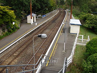
Khandallah railway station is one of eight stations on the Johnsonville Line, a commuter branch railway north of Wellington in New Zealand’s North Island. The station was erected and operated by the Wellington and Manawatu Railway Company (WMR) on their line from Wellington to Longburn. From the acquisition of the WMR by the New Zealand Railways Department in 1908 until the opening of the Tawa Flat deviation in 1937, the station was on the North Island Main Trunk Railway.

Raroa railway station, one of eight stations on the Johnsonville Branch, serves the suburbs of Raroa and Broadmeadows. It is one of four stations on the line located on a curve.

Johnsonville railway station is the terminus of the Johnsonville Line, one of eight stations on the commuter branch railway north of Wellington in New Zealand’s North Island. It serves the suburb of Johnsonville, and as a bus interchange attracts traffic from other suburbs to the north and east.
Porirua railway station is an important intermediate station in New Zealand on the Kapiti Line from Wellington and is part of Wellington's Metlink suburban rail network operated by Transdev Wellington.

Crofton Downs is an inner suburb of Wellington, the capital city of New Zealand. It is situated between Ngaio to the northeast, Wilton to the south-west, and Wadestown to the south. Its border runs on the Korimako Stream that flows south into the Kaiwharawhara Stream and then flows down the Ngaio Gorge into Wellington Harbour.
Linden is a part of Tawa, the northernmost suburb of Wellington, New Zealand. Linden lies at the northern end of Tawa, just south of the city of Porirua.
Paparangi, one of the northern suburbs of Wellington in New Zealand, lies approximately 10 km north of the city centre, north-east of Johnsonville, north-west of Newlands and south of Grenada and Woodridge. The population was 2,841 at the time of the 2013 census, an increase of 96 from the 2006 census population.

