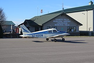
Granite Falls Municipal Airport, also known as Lenzen-Roe Memorial Field, is a public-use airport in Yellow Medicine County, Minnesota, United States. It is owned by the City of Granite Falls and located four nautical miles (7 km) south of its central business district. The airport is situated near State Highway 23.
Abrams Municipal Airport is a city-owned, public-use airport located two nautical miles (3.7 km) north of the central business district of Grand Ledge, a city in Eaton County, Michigan, United States. It is included in the Federal Aviation Administration (FAA) National Plan of Integrated Airport Systems for 2017–2021, in which it is categorized as a local general aviation facility.

Brooks Field is a city-owned, public-use airport located one nautical mile (1.85 km) south of the central business district of Marshall, a city in Calhoun County, Michigan, United States. Brooks Field was officially dedicated in 1931, although the first plane landed there on November 9, 1929.

Benton Municipal Airport is a city-owned, public-use airport located 1 nautical mile west of the central business district of Benton, a city in Franklin County, Illinois, United States. This airport is included in the FAA's National Plan of Integrated Airport Systems (2009–2013), which categorizes it as a general aviation airport. The airport was named 2014 Illinois General Aviation Airport of the Year.
Tower Municipal Airport is a city-owned public-use airport located one nautical mile (2 km) northwest of the central business district of Tower, a city in Saint Louis County, Minnesota, United States. It is located on Lake Vermilion and is also known as Tower Municipal Airport & Seaplane Base.

Middleton Municipal Airport, also known as Morey Field, is a general aviation airport located five miles (8 km) northwest of Middleton, a city in Dane County, Wisconsin, United States. It is included in the Federal Aviation Administration (FAA) National Plan of Integrated Airport Systems for 2025–2029, in which it is categorized as a regional general aviation facility.
Mount Pleasant Municipal Airport is a city-owned public-use airport located two miles (3 km) northeast of the central business district of Mount Pleasant, a city in Isabella County, Michigan, United States. The airport became active in 1940. It serves general aviation for Mount Pleasant and the surrounding area. It is included in the Federal Aviation Administration (FAA) National Plan of Integrated Airport Systems for 2017–2021, in which it is categorized as a local general aviation facility.
Moorhead Municipal Airport is a city-owned public-use airport located in Moorhead, a city in Clay County, Minnesota. It has one runway and, as of 2010, it served general aviation only.
Indy South Greenwood Airport is a city-owned public-use airport in Greenwood, a city in Johnson County, Indiana, United States. It is 10 miles (16 km) southeast of Downtown Indianapolis. The airport was founded in September 1947 and is primarily used for general aviation. The airport has several on-field businesses, including a flight school and maintenance shop. In 2022 the airport was awarded Airport of the Year by Aviation Indiana.
Mora Municipal Airport is a city-owned public-use airport located one mile north-east of the city of Mora, Minnesota; in Kanabec County.Kanabec County, Minnesota
Blue Earth is a city-owned public-use airport located three miles south of the city of Blue Earth, Minnesota in Faribault County.
Cook Municipal Airport is a city-owned public-use airport located two miles south of the city of Cook, Minnesota in Saint Louis County.
Worthington Municipal Airport is a city-owned public-use airport located 2 miles (3.2 km) north of the city of Worthington, in Nobles County, Minnesota, United States.
Paynesville Municipal Airport is a city-owned public-use airport located one mile southwest of the city of Paynesville, Minnesota in Stearns County.
Eveleth–Virginia Municipal Airport is a city-owned public-use airport located three miles southeast of the city of Eveleth, Minnesota
Glencoe Municipal Airport also known as Vernon Perschau Field is a city-owned public-use airport located three miles south-east of the city of Glencoe, Minnesota in McLeod County.
Hawley Municipal Airport is a city-owned public-use airport located four miles south-east of the city of Hawley, Minnesota in Clay County.

Rushford Municipal Airport also known as Robert W. Bunke Field is a city-owned public-use airport located three miles west of the city of Rushford, Minnesota in Fillmore County.
Windom Municipal Airport is a city-owned public-use airport located three miles north of the city of Windom, Minnesota in Cottonwood County.
Hallock Municipal Airport is a city-owned public-use airport located one mile south of the city of Hallock, Minnesota in Kittson County.


