The Pilbara is a large, dry, thinly populated region in the north of Western Australia. It is known for its Aboriginal peoples; its ancient landscapes; the red earth; and its vast mineral deposits, in particular iron ore. It is also a global biodiversity hotspot for subterranean fauna.

Western Australia (WA) is divided into regions according to a number of systems.

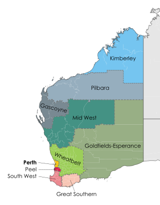
The Wheatbelt is one of nine regions of Western Australia defined as administrative areas for the state's regional development, and a vernacular term for the area converted to agriculture during colonisation. It partially surrounds the Perth metropolitan area, extending north from Perth to the Mid West region, and east to the Goldfields–Esperance region. It is bordered to the south by the South West and Great Southern regions, and to the west by the Indian Ocean, the Perth metropolitan area, and the Peel region. Altogether, it has an area of 154,862 square kilometres (59,793 sq mi).

The Division of Kalgoorlie was an Australian electoral division in the state of Western Australia, named after the city of Kalgoorlie. The Division was proclaimed in 1900 as one of the original 65 divisions to be contested at the first federal election in 1901. In its final form, it covered most of the land area of Western Australia, with a size of 2,295,354 square kilometres (886,241 sq mi)—over 90 percent of the state's landmass. It included the Goldfields-Esperance, Gascoyne, Pilbara and Kimberley regions of Western Australia, in addition to the eastern and far northern parts of the Mid West region, and the town of Merredin. It was the largest single-member electorate by area in the world—almost a third of the continent.
Horizon Power is a commercially focused, state government-owned, power company that provides power supplies to Western Australia. It is responsible for generating, procuring, distributing and retailing electricity to residential, industrial and commercial customers and resource developments in its service area.
Pilbara newspapers is a selection of newspapers published in the Pilbara region of Western Australia.

The Division of Durack is an Australian Electoral Division in the state of Western Australia.

The Australian Country Football League (WACFL) is the governing body for the sport of Australian rules football in the non-metropolitan areas of Western Australia. The organisation was founded in 1973 as the Western Australian National Country Football League (WANCFL), its name to the current in 1979. The WACFL is also responsible for organising the Landmark Country Football Championships, contested between the various regional sides. The Australian Country Football Championships were hosted by Bunbury in 2004.

Highways and main roads in the Wheatbelt region of Western Australia form the basis of a road network, which is primarily used by the mining, agriculture, and tourism industries. Main Roads Western Australia maintains and controls these major roads, with offices based in Northam and Narrogin.
Main Roads Western Australia controls the major roads in the state's Mid West region. There are four main highways through the Mid West: The north-south coastal route of Brand Highway and North West Coastal Highway, the inland alternative Great Northern Highway, and the northern section of Goldfields Highway, which links Meekatharra with Kalgoorlie. A network of main roads connects towns within the Mid West to each other, the highways, and neighbouring regions, with local roads providing additional links and access to smaller townsites. Roads are often named after the towns they connect.
Main Roads Western Australia controls the major roads in the state's Gascoyne region. North West Coastal Highway, a north-south route near the coastline, is the main highway the region. A series of main roads connect coastal towns to the highway, and local roads provide additional links and access to the inland portion of the region. Roads are often named after the towns or areas they connect.
Main Roads Western Australia controls the major roads in the state's Kimberley region. Great Northern Highway is the major road connection through the region, with sealed roads spurring off it to connect to population centres, and unsealed roads offering an alternative route between Derby and Wyndham.
Newspapers published or distributed in the Gascoyne region of Western Australia have been spread over a large distance, and in varying degrees of success. The region has a low population density, and some communities, apart from Carnarvon, would not be sufficient to support long term newspaper production.
A modest number of newspapers have been produced in, or for, the Kimberley region of Western Australia. Few are still being published today. Some of the newspapers reflect the economic interests of the region, but not to the same extent that is seen in Pilbara newspapers. There is some cross-over between newspapers distributed in both the Kimberley and the Pilbara.
This is a list of newspapers published in, or for, the Great Southern region of Western Australia.
Main Roads Western Australia controls the major roads in the state's Goldfields-Esperance region. While the region is the state's largest, the major roads are restricted to the region's western and southern edges. From the major population centres of Kalgoorlie and Coolgardie, Great Eastern Highway heads west towards Perth via the Wheatbelt ; Coolgardie–Esperance Highway leads south to the port of Esperance via Norseman; and Goldfields Highway proceeds north to Wiluna and then on to the Mid West Region. From Norseman, Eyre Highway takes interstate traffic east across the Nullarbor Plain and into South Australia.
