Bhadarsa is a town and nagar panchayat in Ayodhya district in state of Uttar Pradesh, India. Bhadarsa is 22 km south of district headquarters Ayodhya city.
Bhatni Bazar is a town and a Nagar Panchayat in the Deoria district in the Indian state of Uttar Pradesh. It is the capital of the Development block Bhatni.
Bhatpar Rani is a town and tehsil in Deoria District in the state of Uttar Pradesh in India. It belongs to Gorakhpur Division. It is located 48 km towards East from District headquarters Deoria.The Member of Legislative Council of Bhatpar Rani Constituency is Shri. Sabhakunwar Kushwaha In Bhatpar Rani, the block number of village is 127. The biggest village in this tehsil is Sarayan. Khan Sir(Teacher), Shilpi Raj(Singer) were born here.
Doghat is a town and a Nagar Panchayat in Baghpat district in the state of Uttar Pradesh, India.
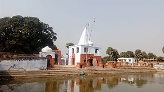
Pharenda, or Anandnagar, is a city in the Maharajganj district of the province of Uttar Pradesh in northern India. It is located approximately 44 kilometres north of Gorakhpur near the border with Nepal. District of Pharenda is Maharajganj. This is situated on the Buddhist Circuit which is built from Sarnath to Lumbini. It lies on NH-24 and near NH 29. It is about 45 km from Gorakhpur, 40 km from Siddharthnagar, 30 km from Maharajganj and 55 km from Sonauli Indo-Nepal Border. This place is named after Seth Anandram Jaypuriya. There is closed sugar Mill which was started in about 1935 and closed in 1995. Near Anand Nagar there is a temple is Durga devi mandir, popularly known as Lehara Devi mandir.
Kerakat or Kirakat is a town and nagar panchayat in Jaunpur district of the Indian state of Uttar Pradesh with a population of approximately 13,500. It is situated near the Gomati River, which helps the land around the town stay very fertile. Kerakat or Kirakat forms a part of Varanasi Division. It is located 30 km east of the city of Jaunpur and 279 km from Lucknow, the capital of Uttar Pradesh.
Nasrullaganj, also known as Bherunda, is a nagar panchayat in Sehore district in the Indian state of Madhya Pradesh. The nearest airport is in Bhopal.
Pachperwa is a town and a nagar panchayat in Balrampur district in the Indian state of Uttar Pradesh. Pachperwa is situated 54 km (34 mi) from district headquarters Balrampur and 200 km (120 mi) from state capital Lucknow. The National Highway 730 connected the town to district headquarters as well as other cities.

Tulsipur is a town and tehsil in the Balrampur district of the Indian state of Uttar Pradesh.

Dewa Sharif or Dewa is a town and a nagar panchayat in Barabanki district in the state of Uttar Pradesh, India. It is famous for the shrine of Haji Waris Ali Shah. This town is also known by the name of Dewa Sharif in respect for the shrine. It is about 26 km north-east of the capital Lucknow.

Balrampur district is one of the district of the Indian state of Uttar Pradesh and is a part of Devipatan division as well as the historic Awadh regions. It has been cut from the adjacent district Gonda in 1997. Located on the banks of the West Rapti River. Balrampur is known for the temple of Pateshwari Devi, a Shakti Pitha, and for the ruins of the nearby ancient city of Sravasti, now a pilgrimage site for Buddhists and Jains. The nearest airport is Shravasti airport 23.3 kilometres (14.5 mi) from the town but it is not an international and regular airport; the nearest international and regular airport is Chaudhary Charan Singh International Airport in Lucknow, 235 kilometres (146 mi) away. Lucknow is the capital city of Uttar Pradesh and is 220 kilometres (140 mi) from Balrampur district headquarters.
Paraspur is a Nagar Panchayat and block headquarter in Gonda district, Uttar Pradesh, India. It is the biggest Block Panchayat in Gonda district, with 64 Village Panchayats and 91 villages. It comes under Colonelganj legislative assembly. The total population of Paraspur block Panchayat is 203,937, which consists of 105,736 males and 98,201 females, with a population density of 687 per square kilometer. Paraspur is a rural township around 20 km from Gonda and 100 km from Lucknow. Colonelganj, a historical town associated with the mutiny of 1857, lies 14 km to the north. About 22 km west lies Tikaitnagar, a town in Bara-Banki District. Colonelganj railway station, on the Bara-Banki—Gonda route, is the nearest railway station, and the nearest airport is Amausi Airport.
Goshainganj, also known as Gosainganj, is a town and nagar panchayat in the Ayodhya district of the Indian state of Uttar Pradesh. Located 32 km from the district headquarters Ayodhya, Goshainganj has one of the oldest markets of the district.
Walidpur is a village in Mau district in the Indian state of Uttar Pradesh.
Bairia is a nagar panchayat in Bairia tehsil in Ballia District of Uttar Pradesh State, India. It belongs to Azamgarh Division. It is located 35 km to the east of the district headquarters Ballia. It is a block headquarters and tehsil headquarters. Bairia is a nagar panchayat located in Bairia Tehsil of Ballia district, Uttar Pradesh with total 3904 families residing. The Bairia nagar panchayat has population of 28394 of which 14981 are males while 13413 are females as per Population Census 2011.
Gurua is a community development block that forms an administrative division in Gaya district, Bihar state, India.
Sandaur is a village in the Malerkotla district of Punjab, India. Formerly a part of the Sangrur district, it is located in the Malerkotla tehsil.
Dhanuri is a village in Malsisar Tehsil in Jhunjhunu District of Rajasthan State, India. Dhanuri village is located in Alsisar Tehsil of Jhunjhunun district in Rajasthan, India. It is situated 15km away from Jhunjhunun, which is both district & sub-district headquarter of Dhanuri village. As per 2009 stats, Dhanuri village is also a gram panchayat. By: Ayaj Khan.
Gainsari is a nagar panchayat in Tulsipur tehsil, Balrampur district in the state of Uttar Pradesh, India. It is near the India-Nepal border and is 238 km far from Lucknow capital city of Uttar Pradesh. It has an average elevation of 109 metres above sea level.
Sadullanagar SMT Village is a village in Uttar Pradesh, India. Utraula, Balrampur, Faizabad, Tulsipur are the nearby Cities to Sadullanagar. Sadullanagar Pin Code is 271307. Sadullanagar is a legislative assembly constituency in Uttar Pradesh. Since 2008, Sadullanagar Assembly constituency merged as Utraula Assembly Constituency. ISadullanagar comes under Gonda Lok Sabha constituency. Sadullanagar is saprated from Utraula by Kunwa River and by Bishui river from Mankapur. Sadullanagar people speak Hindi, Urdu as their main communication language. located 169 km from State capital Lucknow.