
The Alpine region of Switzerland, conventionally referred to as the Swiss Alps, represents a major natural feature of the country and is, along with the Swiss Plateau and the Swiss portion of the Jura Mountains, one of its three main physiographic regions. The Swiss Alps extend over both the Western Alps and the Eastern Alps, encompassing an area sometimes called Central Alps. While the northern ranges from the Bernese Alps to the Appenzell Alps are entirely in Switzerland, the southern ranges from the Mont Blanc massif to the Bernina massif are shared with other countries such as France, Italy, Austria and Liechtenstein.
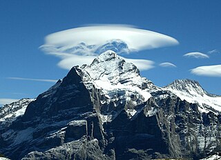
The Wetterhorn is a peak in the Swiss Alps towering above the village of Grindelwald. Formerly known as Hasle Jungfrau, it is one of three summits on a mountain named the "Wetterhörner", the highest of which is the Mittelhorn and the lowest and most distant the Rosenhorn. The latter peaks are mostly hidden from view from Grindelwald.

Meiringen is a municipality in the Interlaken-Oberhasli administrative district in the canton of Bern in Switzerland. Besides the village of Meiringen, the municipality includes the settlements of Balm, Brünigen, Eisenbolgen, Hausen, Prasti, Sand, Stein, Unterbach, Unterheidon, Wylerli and Zaun.

Grindelwald is a village and municipality in the Interlaken-Oberhasli administrative district in the canton of Berne in Switzerland. In addition to the village of Grindelwald, the municipality also includes the settlements of Alpiglen, Burglauenen, Grund, Itramen, Mühlebach, Schwendi, Tschingelberg and Wargistal.

The Kleine Scheidegg is a mountain pass at an elevation of 2,061 m (6,762 ft), situated below and between the Eiger and Lauberhorn peaks in the Bernese Oberland region of Switzerland. The name means "minor watershed", even though it is actually higher than the neighbouring Grosse Scheidegg. Possibly this is because Kleine Scheidegg is a watershed between the two arms of the Lütschine river, while Grosse Scheidegg divides the Lütschine from the Rychenbach stream.

The Bernese Oberland is the higher part of the canton of Bern, Switzerland, in the southern end of the canton, and one of the canton's five administrative regions.

The Grosse Scheidegg is a mountain pass in the Bernese Alps of Switzerland, The pass crosses the col between the Schwarzhorn and the Wetterhorn mountains at an elevation of 1,962 m (6,437 ft).
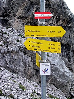
The Alpine Pass Route is a long-distance hiking trail through the Alps in Switzerland, part of the Via Alpina route. It starts in Sargans in eastern Switzerland, and crosses the heart of country westwards to finish in Montreux on the shore of Lake Geneva. The total route covers over 325 kilometres (202 mi) and crosses 16 mountain passes, and takes 15 or more walking days to complete.

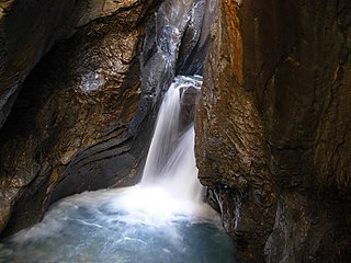
The Aare Gorge is a section of the river Aare that carves through a limestone ridge near the town of Meiringen, in the Bernese Oberland region of Switzerland. The gorge is an indirect product of glaciation; 10,000 years ago, just as the Ice Age was coming to an end, torrential runoff water from melting glaciers eroded a deep, narrow chasm through the limestone barrier. Although barely 2 kilometres (1 mi) long, this passage is bordered by sheer cliffs up to 50 m (160 ft) high on either side. The gorge varies in width from some 30 metres (98 ft) at its widest to just 1 metre at its narrowest.
Schattenhalb is a municipality in the Interlaken-Oberhasli administrative district in the canton of Bern in Switzerland. The municipality includes the settlements of Willigen, Geissholz, Falcheren and Lüögen.

The Oberhasli is a historical Landvogtei or Talschaft in the Bernese Highlands, Switzerland, bordering on the cantons of Obwalden (OW), Nidwalden (NW), Uri (UR) and Wallis (VS).

Grindelwald is a railway station in the village and municipality of Grindelwald in the Swiss canton of Bern. The station is the terminus of both the Berner Oberland Bahn (BOB), whose trains operate services to Interlaken Ost, and of the Wengernalpbahn (WAB), whose trains operate to Kleine Scheidegg via Grindelwald Grund.
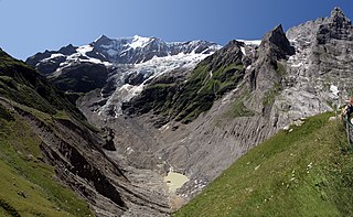
The Lower Grindelwald Glacier is a Glacier in the Swiss Bernese Alps, situated to the south-east of Grindelwald. It starts below the Agassizhorn and the Strahlegghörner and is connected with the Finsteraar Glacier via the Finsteraarjoch.

Kleine Scheidegg is a railway station that is situated on the summit of the Kleine Scheidegg Pass in the Bernese Oberland region of Switzerland. The pass houses a complex of hotels and railway buildings. Administratively, the station is in the municipality of Lauterbrunnen in the canton of Bern.

The Schwarzhorn is a mountain of the Bernese Alps, located between Brienz and Grindelwald in the Bernese Oberland. With a height of 2,928 metres above sea level, it is the highest summit of the group north of the Grosse Scheidegg Pass. The Schwarzhorn is also the highest point in the municipality of Brienz.

Jungfraujoch is an underground railway station situated below the Jungfraujoch col in the Bernese Oberland region of Switzerland. At 3,454 meters (11,332 ft) above sea level, this is the highest railway station in Europe, and is close to the summits of the Eiger, Jungfrau and Mönch mountains.

Meiringen railway station is a railway station, in the town of Meiringen in the Swiss canton of Bern, and at the junction of two railway lines. The Brünig line of the Zentralbahn is an inter-regional metre gauge railway that links Interlaken and Lucerne, whilst the Meiringen–Innertkirchen railway (MIB) of Grimselwelt is a local railway that links to Innertkirchen and the Aare Gorge.

Meiringen air base, also known as the Unterbach military airfield, is a Swiss military airbase located near the hamlet of Unterbach and the town of Meiringen, in the canton of Bern. It is one of three main airbases of the Swiss Air Force.
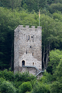
The Restiturm, or Burgruine Resti, is a ruined castle in the municipality of Meiringen in the Swiss canton of Bern. The original castle was built in the 13th century and has been rebuilt several times. The castle is situated at the foot of the Hasliberges. The best preserved part of the castle is its tower, which still stands to this day. An examination of the castle interior reveals that the castle was constructed inside out, with the core's construction beginning in 1250. It took another 50 years before the iconic tower was completed.


