Gräfenthal is a town in the district of Saalfeld-Rudolstadt in Thuringia, Germany.

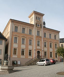
Königsee is a town and a municipality in the district of Saalfeld-Rudolstadt, in Thuringia, Germany. It is situated 12 kilometres (7.5 mi) east of Ilmenau, and 35 kilometres (22 mi) south of Erfurt. The present municipality was formed on 31 December 2012 by the merger of the former municipalities Königsee and Rottenbach, under the name Königsee-Rottenbach. On 1 January 2019 the former municipalities Dröbischau and Oberhain were absorbed, and the name was changed to Königsee.

Neuhaus am Rennweg is a town in the district of Sonneberg, in Thuringia, Germany. It is situated in the Thuringian Forest, 17 km north of Sonneberg, and 22 km southwest of Saalfeld. The former municipalities Lichte and Piesau were merged into Neuhaus am Rennweg in January 2019.

Oberweißbach is a town and a former municipality in the district of Saalfeld-Rudolstadt, in Thuringia, Germany. Since 1 January 2019, it is part of the town Schwarzatal.

Remda-Teichel is a town and a former municipality in the district of Saalfeld-Rudolstadt, in Thuringia, Germany. It is situated 15 km northwest of Saalfeld, and 28 km southeast of Erfurt. Since 1 January 2019, it is part of the town Rudolstadt.
Allendorf is a municipality in the district Saalfeld-Rudolstadt, in Thuringia, Germany.

Kaulsdorf is a municipality in the district Saalfeld-Rudolstadt, in Thuringia, Germany.

Rohrbach (help·info) is a municipality in the district Saalfeld-Rudolstadt, in Thuringia, Germany.

Sitzendorf is a municipality in the district Saalfeld-Rudolstadt, in Thuringia, Germany.
Cursdorf is a municipality in the district Saalfeld-Rudolstadt, in Thuringia, Germany.

Deesbach is a municipality in the district Saalfeld-Rudolstadt, in Thuringia, Germany.

Döschnitz is a municipality in the district Saalfeld-Rudolstadt, in Thuringia, Germany.

Katzhütte is a municipality in the district Saalfeld-Rudolstadt, in Thuringia, Germany.
Lichte is a village and a former municipality in the district of Sonneberg in Thuringia, Germany, close to the Thuringian Rennsteig. Formerly in the district Saalfeld-Rudolstadt, it is part of the town Neuhaus am Rennweg since January 2019.
Piesau is a village and a former municipality in the district of Sonneberg in Thuringia, Germany, close to the Thuringian Rennsteig. Formerly in the district Saalfeld-Rudolstadt, it is part of the town Neuhaus am Rennweg since January 2019.

Unterweißbach is a municipality in the district Saalfeld-Rudolstadt, in Thuringia, Germany.
Schmiedefeld is a village and a former municipality in the district Saalfeld-Rudolstadt, in Thuringia, Germany close to the Thuringian Rennsteig. Since 1 January 2019, it is part of the town Saalfeld. Before, it belonged to the municipal association Lichtetal am Rennsteig, which consisted of the municipalities Lichte, Piesau, Reichmannsdorf, and Schmiedefeld.
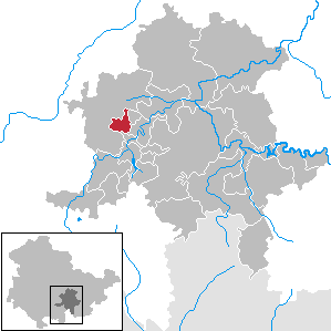
Uhlstädt-Kirchhasel is a municipality in the district Saalfeld-Rudolstadt, in Thuringia, Germany. On 1 December 2007, the former municipalities Großkochberg and Heilingen were incorporated by Uhlstädt-Kirchhasel. The valley of the river Saale is the centre of Uhlstädt-Kirchhasel. Both Uhlstädt and Kirchhasel are villages inside this valley, which divides the municipality into a northern and a southern part. The nearest bigger towns are Rudolstadt(about 7 km away), Saalfeld(about 11 km away) and Jena(about 25 km away).
Lichtetal am Rennsteig is a former municipal association in the district of Saalfeld-Rudolstadt, in Thuringia, Germany. The seat of government was in Lichte. It was disbanded in January 2019.

The Aßberg is a 703 m high mountain located in the Thuringian Highland, Thuringia (Germany).


