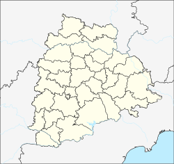
Khammam, also known as Khammamett is the city in Khammam district of the Indian state of Telangana.It is the fourth largest city in the state.It is the headquarters of the Khammam district and Khammam mandal also. It is located about 193 kilometres (120 mi) east of the state capital, Hyderabad, 61 kilometres (38 mi) from Suryapet, 120 kilometres (75 mi) from Warangal and also it is located about 121 kilometres (75 mi) North of the Andhra Pradesh state capital, Amaravathi. The river Munneru flows on the western side of the city. As of 2011 census of India, Khammam urban agglomeration has a population of 2,62,255.However, on 19 October 2012, the civic body of Khammam was upgraded to Municipal corporation Post upgradation to corporation Khammam population is approximated to be 3,07,000.

Bhadrachalam is a census town in the Indian state of Telangana, Bhadradri Kothagudem district. It is an important Hindu pilgrimage town with an existence of the Bhadrachalam Temple of Lord Rama, situated on the banks of Godavari river. It is located 312 kilometres (194 mi) from east of state capital, Hyderabad,115 kilometres (71 mi) from Khammam, 165 kilometres (103 mi) from Rajamahendravaram, 225 kilometres (140 mi) from Guntur, 192 kilometres (119 mi) from Vijayawada,177 kilometres (110 mi) from Suryapet, 180 kilometres (112 mi) from Warangal and 220 kilometres (137 mi), from the Andhra Pradesh State Capitals Amaravathi, Visakhapatnam.

Nalgonda is a city and municipality in the Indian state of Telangana. It is the headquarters of the Nalgonda district, as well as the headquarters of the Nalgonda mandal in the Nalgonda revenue division..It is located about 90 kilometres (56 mi) from the state capital Hyderabad

Khammam District is a district in the eastern region of the Indian state of Telangana. The city of Khammam is the district headquarters. The district shares boundaries with Suryapet, Mahabubabad, Bhadhradhri districts and with Andhra pradesh state.

Nizamabad District is located in the north-western region in the Indian state of Telangana. The city of Nizamabad is the district headquarters.

Warangal Urban District is located in the northern region of the Indian state of Telangana. The district headquarters are located at Hanamkonda.

Malkajgiri is an urban area of Secunderbad city in the Medchal–Malkajgiri district of the Indian state of Telangana. It is the headquarters of Malkajgiri mandal in Malkajgiri revenue division. Malkajgiri is one of the most populated mandals in the Medchal District. It is governed by the Greater Hyderabad Municipal Corporation, and has representation in the Telangana Legislative. It was a part of Ranga Reddy district before the re-organisation of districts in the state. Now it's in Medchal-Malkajgiri district.

Bheemavaram is a village in Khammam district of the Indian state of Telangana. It is located in Yerrupalem mandal of Khammam revenue division.

Palwancha is a town in Bhadradri district of the Indian state of Telangana. It is located in Palwancha mandal of Kothagudem revenue division.

Sathupally is a town in Khammam district of the Indian state of Telangana. It is a Municipality in Sathupally mandal of Khammam revenue division.

Penuganchiprolu is a village in Krishna district of the Indian state of Andhra Pradesh. It is the mandal headquarters of Penuganchiprolu mandal in Vijayawada revenue division.

Srungavarapukota popularly known by its abbreviated form S.Kota is a neighbourhood in the district of Vizianagaram, India. S.Kota is located on Visakhapatnam – Araku road. The town was upgraded from gram panchayat to Nagar Panchayat in the year 2011. It's also famous for Shiva temple and punyagiri Waterfalls. It's a good picnic spot. Well connected to Visakhapatnam through bus service.

Wyra is a municipal council, town and mandal headquarters in Khammam district of Telangana, India. The nearest city is Khammam. The nearest railway station is Khammam. The nearest airport is Vijayawada airport. There is one movie theatre – Vasavi Theatre. The present MLA of Wyra constituency is Lavudya Ramulu Nayak. This town is a Municipal council. The town is the main joint for Madhira, Khammam, Sathupally, Kothagudem and Tallada. Wyra Reservoir is a tourist attraction in Khammam district. The nearest bus station is TSRTC Wyra Bus Station. The assembly constituency contains Konijerla, Karepalli, Julurpadu, Enkoor and Wyra. Wyra was a revenue mandal of Khammam revenue division. There are some private schools.

Kusumanchi is a village in Khammam district of Telangana in India. It is the headquarters of Kusumanchi mandal.

Thorrur is a revenue division, Mandal and a municipality in Mahabubabad district of Telangana, India. It is located on Jayaprakash Narayana road between Warangal and Khammam. It is at about 50 km from Warangal, 62 km from Suryapet and 70 km from Khammam. It is a rapidly growing town due to its location.

Yerupalem or Yerrupalem or Errupalem is a mandal in Khammam district, Telangana, India.

Jaggayyapeta mandal is one of the 50 mandals in Krishna district of the state of Andhra Pradesh in India. It is under the administration of Vijayawada revenue division and the headquarters are located at Jaggayyapeta town. Krishna River flows through the mandal and is bounded by Penuganchiprolu, Nandigama, Chandarlapadu mandals of Krishna district, some part of Guntur district, Nalgonda and Khammam districts of Telangana.

Mothugudem is a village in the Khammam district of the Indian state of Telangana. It is located in Chintur mandal.

Khanapuram Haveli is a census town in Khammam district of the Indian state of Telangana. It is located in Khammam (urban) mandal of Khammam revenue division. The town is a constituent of Khammam Urban Agglomeration.
Khammam (urban) mandal is one of the 46 mandals in Khammam district of the Indian state of Telangana. It is under the administration of Khammam revenue division and has its headquarters at Khammam. The mandal is bounded by Kamepalli, Enkuru, Konijerla, Khammam (rural) and Chintakani mandals.


