Remonstrants Hofje

Last updated
Remonstrantse hofje in the Ursulastraat in Haarlem Remonstrantse hofje.JPG
Remonstrantse hofje in the Ursulastraat in Haarlem

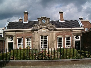
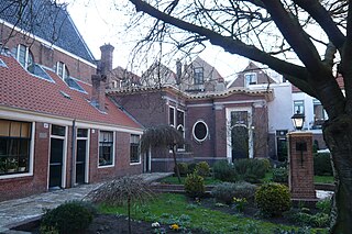
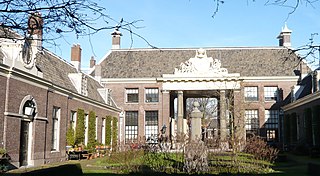
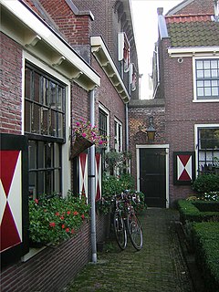
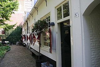
The Remonstrantshofje is a hofje (courtyard surrounded by almshouses) in Haarlem, Netherlands. It is one of the hofjes in Haarlem that is traditionally used to provide housing for elderly people. [1]

Hofje almshouses around a courtyard

A hofje is a Dutch word for a courtyard with almshouses around it. They have existed since the Middle Ages.

Haarlem City and municipality in North Holland, Netherlands

Haarlem is a city and municipality in the Netherlands. It is the capital of the province of North Holland and is situated at the northern edge of the Randstad, one of the most populated metropolitan areas in Europe. Haarlem had a population of 159,556 in 2017. It is a 15-minute train ride from Amsterdam, and many residents commute to the country's capital for work.

Netherlands Constituent country of the Kingdom of the Netherlands in Europe

The Netherlands is a country located mainly in Northwestern Europe. The European portion of the Netherlands consists of twelve separate provinces that border Germany to the east, Belgium to the south, and the North Sea to the northwest, with maritime borders in the North Sea with Belgium, Germany and the United Kingdom. Together with three island territories in the Caribbean Sea—Bonaire, Sint Eustatius and Saba— it forms a constituent country of the Kingdom of the Netherlands. The official language is Dutch, but a secondary official language in the province of Friesland is West Frisian.

It was founded in 1773 by Justus and Isabella van Leeuwarden on the site of the old Ursula cloister. The hofje has places for six women.

Isabella van Leeuwarden Dutch hofje founder in Haarlem

Isabella van Leeuwarden was a Dutch Mennonite businesswoman and hofje founder of Haarlem.

Cloister open space surrounded by covered walks or open galleries

A cloister is a covered walk, open gallery, or open arcade running along the walls of buildings and forming a quadrangle or garth. The attachment of a cloister to a cathedral or church, commonly against a warm southern flank, usually indicates that it is part of a monastic foundation, "forming a continuous and solid architectural barrier... that effectively separates the world of the monks from that of the serfs and workmen, whose lives and works went forward outside and around the cloister."

The entrance of the hofje is in a remaining wall of the old cloister, and the old cloister chapel serves as the entrance hall.

Related Research Articles

Hofje van Bakenes

The Hofje van Bakenes or Bakenesserkamer is a hofje in Haarlem, Netherlands, located between the Bakenessergracht and the Wijde Appelaarsteeg. In the Middle Ages "kamer" or "room" meant house. Usually the houses within a hofje consisted of just one room.

Hofje van Noblet hofje in Haarlem

The Hofje van Noblet is a hofje in Haarlem, Netherlands.

Frans Loenenhofje Hofje in Haarlem

The Frans Loenenhofje is a hofje in Haarlem, Netherlands, on the Witte Heren straat.

Lutherse Hofje

The Lutherse Hofje is a hofje in Haarlem, Netherlands.

Hofje van Staats

The Hofje van Staats is a hofje in Haarlem, Netherlands, on the Jansweg 39, close to the Haarlem railway station.

Hofje van Loo

The Hofje van Loo is a hofje on the Barrevoetstraat 7 in Haarlem, Netherlands.

Teylers Hofje Almshouse in Haarlem

The Teylershofje is a hofje in Haarlem, Netherlands with 24 houses.

Hofje In den Groenen Tuin

The Hofje in den Groenen Tuin is a hofje in Haarlem, Netherlands.

Bruiningshofje

The Bruiningshofje is a hofje in Haarlem, Netherlands.

Brouwershofje

The Brouwershofje is a hofje on the Tuchthuisstraat in Haarlem, Netherlands.

Hofje van Willem Heythuijsen hofje in Haarlem, Netherlands

The Hofje van Willem Heythuijsen is a hofje in Haarlem, Netherlands. It was founded in 1650 by the testament of Willem van Heythuysen on the site of his summer residence outside the city walls of Haarlem on land that was considered Heemstede property until it was annexed in 1927. It is one of the few hofjes of Haarlem to be built outside the city walls. It has a 'T' shape and has a small open courtyard and a garden still intact.

Wijnbergshofje

The Wijnbergshofje is a hofje in Haarlem, Netherlands, on the Barrevoetstraat.

Zuiderhofje

The Zuiderhofje is a hofje in Haarlem, Netherlands.

Vrouwe- en Antonie Gasthuys

The Vrouwe- en Antonie Gasthuis is a hofje on the Klein Heiligland 64a in Haarlem, Netherlands. It is open on weekdays from 10-17.00.

Proveniershuis

The Proveniershuis is a hofje and former schutterij on the Grote Houtstraat in Haarlem, Netherlands.

Hofje Codde en Van Beresteijn Hofje in Haarlem

The Hofje van Codde en Beresteyn is a hofje in Haarlem, Netherlands. The current building is from 1968 and is located on the J. Cuyperstraat, which is named for the architect who designed the Cathedral of Saint Bavo next door, Joseph Cuypers. This hofje is the wealthiest hofje foundation in Haarlem with the most modern facilities for its inhabitants. Poor (devote) Catholic women of Haarlem 60 years and older are still welcome to live there for free.

Johan Enschedé Hof

The Johan Enschedé Hof is a hofje in Haarlem, Netherlands, on the Korte Begijnestraat. Via a rear entrance it is linked to the Hofje van Bakenes.

Coomanshof

The Coomanshof is a former hofje in Haarlem, Netherlands, on the Witte Heren straat.

St. Barbara Gasthuis doorway of former hofje in Haarlem

The St. Barbara Gasthuis was a hospital and later a hofje on the Jansstraat in Haarlem, Netherlands. All that remains is a former gateway.

References

  1. Haarlems hofjes, Dr. G. H. Kurtz, Schuyt & Co C.V., Haarlem, 1972, ISBN   90-6097-027-6

Coordinates: 52°23′00″N4°38′01″E / 52.38333°N 4.63361°E / 52.38333; 4.63361

Geographic coordinate system Coordinate system

A geographic coordinate system is a coordinate system that enables every location on Earth to be specified by a set of numbers, letters or symbols. The coordinates are often chosen such that one of the numbers represents a vertical position and two or three of the numbers represent a horizontal position; alternatively, a geographic position may be expressed in a combined three-dimensional Cartesian vector. A common choice of coordinates is latitude, longitude and elevation. To specify a location on a plane requires a map projection.