Nassau County is a county of the U.S. state of Florida. According to the United States Census, the county's population was 82,721 in 2017.

The white stork is a large bird in the stork family, Ciconiidae. Its plumage is mainly white, with black on its wings. Adults have long red legs and long pointed red beaks, and measure on average 100–115 cm (39–45 in) from beak tip to end of tail, with a 155–215 cm (61–85 in) wingspan. The two subspecies, which differ slightly in size, breed in Europe, northwestern Africa, southwestern Asia and southern Africa. The white stork is a long-distance migrant, wintering in Africa from tropical Sub-Saharan Africa to as far south as South Africa, or on the Indian subcontinent. When migrating between Europe and Africa, it avoids crossing the Mediterranean Sea and detours via the Levant in the east or the Strait of Gibraltar in the west, because the air thermals on which it depends for soaring do not form over water.

The eastern towhee is a large New World sparrow. The taxonomy of the towhees has been under debate in recent decades, and formerly this bird and the spotted towhee were considered a single species, the rufous-sided towhee.
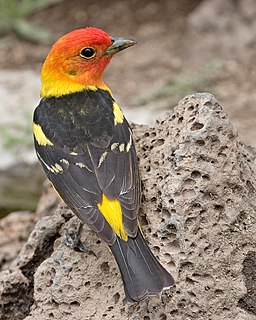
The western tanager, is a medium-sized American songbird. Formerly placed in the tanager family (Thraupidae), it and other members of its genus are now classified in the cardinal family (Cardinalidae). The species's plumage and vocalizations are similar to other members of the cardinal family.
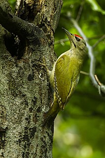
The grey-headed woodpecker, also known as the grey-faced woodpecker, is a Eurasian member of the woodpecker family, Picidae. Along with the more commonly found European green woodpecker and the Iberian green woodpecker, it is one of three closely related sister species found in Europe. Its distribution stretches across large parts of the central and Eastern Palaearctic, all the way to the Pacific Ocean.

Kisatchie National Forest, the only National forest in Louisiana, United States, is located in the forested piney hills and hardwood bottoms of seven central and northern parishes. It is part of the Cenozoic uplands and has large areas of longleaf pine forests. It is one of the largest pieces of natural landscape in Louisiana, with some 604,000 acres (2,440 km2) of public land, more than half of which is vital longleaf pine and flatwoods vegetation. These support many rare plant and animal species. There are also rare habitats, such as hillside seepage bogs and calcareous prairies. The forest also contains and provides a buffer for the Kisatchie Hills Wilderness, a nationally designated wilderness area that contributes to protecting biodiversity of the coastal plain region of the United States.

Picayune Strand State Forest is one of 37 state forests in Florida managed by the Florida Forest Service. The 78,000-acre forest consists primarily of cypress swamps, wet pine flatwoods and wet prairies. It also features a grid of closed roads over part of it, left over from its previous land development schemes.
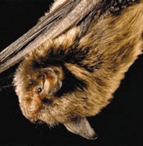
The Indiana bat is a medium-sized mouse-eared bat native to North America. It lives primarily in southern and midwestern states and in parts of the south of the United States and is listed as an endangered species. The Indiana bat is gray, black, or chestnut in color and is 1.2–2 inches and weighs 4.5 – 9.5 grams. It is similar in appearance to the more common little brown bat but is distinguished by its feet size, toe hair length, pink lips and a keel on the calcar.
The Florida Trail is one of eleven National Scenic Trails in the United States. It currently runs 1,000 miles (1,600 km), with 300 miles (480 km) planned, from Big Cypress National Preserve to Fort Pickens at Gulf Islands National Seashore, Pensacola Beach. Also known as the Florida National Scenic Trail, the Florida Trail provides permanent non-motorized recreation opportunity for hiking and other compatible activities and is within an hour of most Floridians. The Florida National Scenic Trail is designated as a National Scenic Trail by the National Trails System Act of 1968.

The Sam Houston National Forest, one of four National Forests in Texas, is located 50 miles north of Houston. The forest is administered together with the other three United States National Forests and two National Grasslands located entirely in Texas, from common offices in Lufkin, Texas. The units include Angelina, Davy Crockett, Sabine, and Sam Houston National Forests, plus Caddo National Grassland and Lyndon B. Johnson National Grassland. There are local ranger district offices located in New Waverly.

Kullaberg is a peninsula and nature reserve of land protruding into the Kattegat in Höganäs Municipality near the town of Mölle in southwest Sweden. The site in the province of Skåne is an area of considerable biodiversity supporting a number of rare species and has been designated as an Important Bird Area (IBA) in Sweden as well as a Special Protection Area (SPA). The terrain is dominated by steep cliffs rising from the sea and rocky outcrops on the ridge above, the highest elevation being Mount Håkull at 188 meters. Ridgetop vegetation includes a mixed hardwood broadleaf forest consisting of birch, beech, oak and pine trees with an understory of hawthorn, juniper, wild honeysuckle and blackthorn. Among the notable rare plants are spring vetchling, Lathyrus sphaericus.
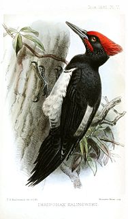
The Tristram's woodpecker is a Korean subspecies of the white-bellied woodpecker. It was firstly identified and described by English scholar and ornithologist Henry Baker Tristram in 1879.

The Storm's stork is a medium-sized stork species that occurs primarily in lowland tropical forests of Indonesia, Malaysia and southern Thailand. It is considered to be the rarest of all storks, and is estimated to number less than 500 wild individuals throughout its geographic range. The population has long been in decline and the primary cause is widely considered to be deforestation of its native habitat.

The peat therapy resortMoorbad Gmös in the vicinity of the town of Laakirchen is one of the few bogs in the Alpine foothills of Upper Austria. The bog dates back to the Mindel glaciation and was created by a "dead-ice hole". In 1987 the local authorities of Upper Austria declared the area of 3.4 ha of the Gmöser Moor a natural preserve. A path around the area has since then given the visitor the opportunity of observing rare flora and fauna. In 2002 the spa was chosen as background scenery for the TV-production Schlosshotel Orth.

Dotzheim is a western borough of Wiesbaden, capital of the state of Hesse, Germany. It is the second largest borough of the city by area and, with over 26,000 inhabitants the second-most populated of Wiesbaden's suburban boroughs. It was the largest village in the former Duchy of Nassau. The formerly independent village was incorporated into Wiesbaden in 1928.

Greenleaf Lake State Recreation Area is a state park unit of Minnesota, USA, currently in development. It includes undeveloped shoreline on both Greenleaf and Sioux Lakes, halfway between the cities of Hutchinson and Litchfield in Meeker County. Portions of the state recreation area (SRA) are open to the public for day-use recreation, but there are no facilities yet on site. The park boundaries were set by the Minnesota Legislature and the state is still acquiring land from willing sellers; two-thirds of the property remain privately owned.
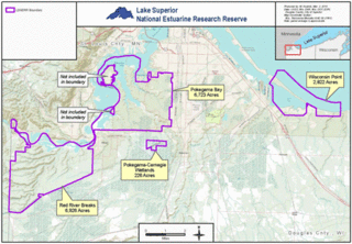
The Lake Superior National Estuarine Research Reserve is located along the St. Louis River in Douglas County, the northwest corner of Wisconsin, United States. It is one of many National Estuarine Research Reserves. It has an area of 16,697 acres (6,757 ha), and was designated in 2010.
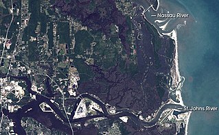
The Machaba Balu Preserve is a nature preserve encompassing 10,000 acres (4,000 ha) of protected lands in northeastern Florida, just to the northeast of Jacksonville, at the confluence of the Nassau, the St. Marys, and the St. Johns Rivers as they flow toward the Atlantic Ocean through a wide network of islands, canals, and tidal marshes. The name Machaba Balu means "saved marsh" in the language of the Timucua people, who occupied the area in pre-Columbian times and met the first European explorers of the region; the Timucua never used this name themselves, however, as it is a modern language construct. The preserve, created with land purchased in 2002 mostly from Alcoma Corporation by the Nature Conservancy, includes 77 islands and numerous individual tracts of tidal marshland between the Nassau and the St. Johns Rivers. The largest clusters lie to the west of Little Talbot Island State Park and on either side of Sisters Creek south of the large fork.