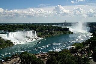
Niagara Falls is a group of three waterfalls at the southern end of Niagara Gorge, spanning the border between the province of Ontario in Canada and the state of New York in the United States. The largest of the three is Horseshoe Falls, which straddles the international border of the two countries. It is also known as the Canadian Falls. The smaller American Falls and Bridal Veil Falls lie within the United States. Bridal Veil Falls is separated from Horseshoe Falls by Goat Island and from American Falls by Luna Island, with both islands situated in New York.

Horseshoe Falls is the largest of the three waterfalls that collectively form Niagara Falls on the Niagara River along the Canada–United States border. Approximately 90% of the Niagara River, after diversions for hydropower generation, flows over Horseshoe Falls. The remaining 10% flows over American Falls and Bridal Veil Falls. It is located between Terrapin Point on Goat Island in the US state of New York, and Table Rock in the Canadian province of Ontario.

Letchworth State Park is a 14,427-acre (5,838 ha) New York State Park located in Livingston County and Wyoming County in the western part of the State of New York. The park is roughly 17 miles (27 km) long, following the course of the Genesee River as it flows north through a deep gorge and over several large waterfalls. It is located 35 miles (56 km) southwest of Rochester and 60 miles (97 km) southeast of Buffalo, and spans portions of the Livingston County towns of Leicester, Mount Morris and Portage, as well as the Wyoming County towns of Castile and Genesee Falls.

Idaho Falls is a city in and the county seat of Bonneville County, Idaho, United States. It is the state's largest city outside the Boise metropolitan area. As of the 2020 census, the population of Idaho Falls was 64,818. In the 2010 census, the population of Idaho Falls was 56,813, with a metro population of 133,265.
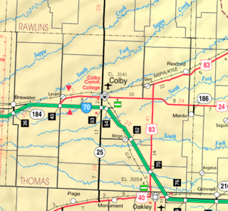
Rexford is a city in Thomas County, Kansas, United States. As of the 2020 census, the population of the city was 197.

Rexford is a town in Lincoln County, Montana, United States. The population was 78 at the 2020 census.
Clifton Park is a suburban town in Saratoga County, New York, United States. According to the United States Census Bureau, the 2020 population was 38,029. The name is derived from an early land patent. The town is in the southern part of Saratoga County, approximately 12 miles (19 km) north of Albany, 7 miles (11 km) northeast of Schenectady, and 10 miles (16 km) south of Saratoga Springs.

Bellows Falls is an incorporated village located in the town of Rockingham in Windham County, Vermont, United States. The population was 2,747 at the 2020 census. Bellows Falls is home to the Green Mountain Railroad, a heritage railroad; the annual Roots on the River Festival; and the No Film Film Festival.

River Falls is a city in Pierce and St. Croix counties in the U.S. state of Wisconsin. It is adjacent to the Town of River Falls in Pierce County and the Town of Kinnickinnic in St. Croix County. River Falls is the most populous city in Pierce County. The population was 16,182 at the 2020 census, with 11,851 residing in Pierce County and 3,149 in St. Croix County. It is part of the Minneapolis-St. Paul metropolitan area and located approximately 30 miles (48 km) east of the center of that region.

Multnomah Falls is a waterfall located on Multnomah Creek in the Columbia River Gorge, east of Troutdale, between Corbett and Dodson, Oregon, United States. The waterfall is accessible from the Historic Columbia River Highway and Interstate 84. Spanning two tiers on basalt cliffs, it is the tallest waterfall in the state of Oregon at 620 ft (189 m) in height. The Multnomah Creek Bridge, built in 1914, crosses below the falls, and is listed on the National Register of Historic Places.

The Soo Locks are a set of parallel locks, operated and maintained by the United States Army Corps of Engineers, Detroit District, that enable ships to travel between Lake Superior and the lower Great Lakes. They are located on the St. Marys River between Lake Superior and Lake Huron, between the Upper Peninsula of the U.S. state of Michigan and the Canadian province of Ontario. They bypass the rapids of the river, where the water falls 21 ft (6.4 m). The locks pass an average of 10,000 ships per year, despite being closed during the winter from January through March, when ice shuts down shipping on the Great Lakes. The winter closure period is used to inspect and maintain the locks.

Chittenango Falls State Park is a 193-acre (0.78 km2) state park located in Madison County, New York, east of Cazenovia Lake. The park features a 167-foot (51 m) waterfall that cascades over roughly 400-million-year-old bedrock. At the bottom of the falls Chittenango Creek flows underneath a wooden bridge. The park offers a variety of activities including picnic tables with pavilions, a playground, a nature trail, hiking, and fishing.

The McAlpine Locks and Dam are a set of locks and a hydroelectric dam at the Falls of the Ohio River at Louisville, Kentucky. They are located at mile point 606.8, and control a 72.9 miles (117.3 km) long navigation pool. The locks and their associated canal were the first major engineering project on the Ohio River, completed in 1830 as the Louisville and Portland Canal, designed to allow shipping traffic to navigate through the Falls of the Ohio.
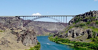
The I. B. Perrine Bridge is a four-lane truss arch span in the western United States. Located at Twin Falls, Idaho, it carries U.S. Highway 93 over the Snake River Canyon, connecting to Jerome County and Interstate 84.
Rexford is a hamlet in Saratoga County, New York, United States, located on the north bank of the Mohawk River. Rexford is in the Town of Clifton Park, near the southwestern town line. Its boundaries, like those of neighboring Alplaus, are unofficial and necessarily ambiguous. To the south, it is bounded by the Mohawk River and Grooms Road and to the west, Alplaus and the Schenectady County line. Route 146 and Vischer's Ferry Road, are probably a reasonable delineations of its northern and eastern boundaries. The ZIP Code is 12148.

The Tahquamenon Falls State Park is a 46,179-acre (186.88 km2) state park in the U.S. state of Michigan. It is the second largest of Michigan's state parks. Bordering on Lake Superior, most of the park is located within Whitefish Township in Chippewa County, with the western section of the park extending into McMillan Township in Luce County. The nearest town of any size is Paradise.

Smith Falls, at 63 feet, is the highest waterfall in the state of Nebraska and the centerpiece of Smith Falls State Park. The state park and falls are located 12 miles (19 km) east-north east of Valentine and 3 miles south west of Sparks, on the south side of the Niobrara River. Access to the falls is via a footbridge across the river from the north side of the park.

Aqueduct is a hamlet in the Town of Niskayuna, Schenectady County, New York, United States. Its center is at the south end of the bridge of New York State Route 146 over the Mohawk River, that connects Schenectady County to the south and Saratoga County to the north. It was formerly a transportation hub. Alexander's Bridge across the Mohawk antedated the Aqueduct. A new Route 146 steel highway bridge, with board pavement, parallel to the Aqueduct was built in the early 20th century. A Schenectady trolley line ended there, the line also serving Luna Park, just over the river in Rexford. There was, in Aqueduct, a staffed station of the Troy & Schenectady Railroad, which operated from 1841 to 1932.


