
The Lepontine Alps are a mountain range in the north-western part of the Alps. They are located in Switzerland and Italy.

There are 101 municipalities in the canton of Graubünden, Switzerland.

The A13 is a motorway, at times an Autostrasse (expressway), which runs from St. Margrethen in northeastern Switzerland through to Ascona in southern Switzerland, crossing the main chain of the Alps in the Grisons area. It is the southern half of European route E43.

The Splügen Pass is an Alpine mountain pass of the Lepontine Alps. It connects the Swiss, Grisonian Splügen 5 kilometres (3.1 mi) to the north 675 metres (2,215 ft) below the pass with the Italian Chiavenna 21 kilometres (13 mi) to the south at the end of the Valle San Giacomo 1,789 metres (5,869 ft) below the pass.
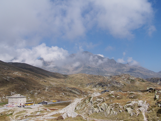
San Bernardino Pass is a high mountain pass in the Swiss Alps connecting the Hinterrhein and the Mesolcina (Misox) valleys between Thusis and Bellinzona. Located in the far eastern side of the Western Alps it is not to be confused with the Great St Bernard Pass and the Little St Bernard Pass. The top of the pass represents both the Italo-German language frontier and the watershed between the Po basin and the Rhine basin. Marscholsee is within the pass at an elevation of 2,053 m (6,736 ft).

The Three Leagues, sometimes referred to as Raetia, was the alliance of 1471 of the League of God's House, the League of the Ten Jurisdictions and the Grey League, leading eventually to the formation of the Swiss canton of Graubünden (Grisons).

The Grey League, sometimes called Oberbund, formed in 1395 in the Vorderrhein and Hinterrhein valleys, Raetia. The name Grey League is derived from the homespun grey clothes worn by the people. The league became part of the canton of Graubünden. The Grey League allied itself to the two other powers of Raetia in 1471, forming the Three Leagues. It was also an associate and ally of the Swiss Confederation and played a role in the buildup to the Thirty Years' War.
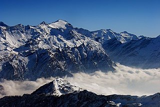
The Rheinwaldhorn is the highest point in the Swiss canton of Ticino at 3,402 metres above sea level. It lies on the border between the cantons of Graubünden and Ticino, in the Adula massif, part of the St. Gotthard massif of the Lepontine Alps in southern Switzerland.

San Bernardino is a mountainous village in the canton of Grisons in Switzerland. It is the southern entry point to the San Bernardino tunnel, which complemented the road over the San Bernardino Pass in 1967, opening a new all-year-round road to crossing the Alps.
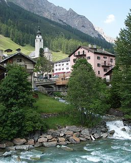
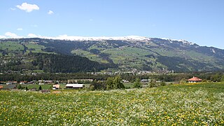
Splügen is a former municipality in the Viamala Region in the Swiss canton of Graubünden. On 1 January 2006 Splügen incorporated its neighbouring municipality of Medels im Rheinwald. On 1 January 2019 the former municipalities of Hinterrhein, Nufenen and Splügen merged to form the new municipality of Rheinwald.
The Valle Mesolcina, also known as the Val Mesolcina or Misox (German), is an alpine valley of the Grisons, Switzerland, stretching from the San Bernardino Pass to Grono where it joins the Calanca Valley. It is the valley formed by the river Moesa.

The Hinterrhein is one of the two initial tributaries of the Rhine in the canton of Graubünden in Switzerland, flowing from the village Hinterrhein near the San Bernardino Pass through the Rheinwald valley into a gorge called Roflaschlucht. In this gorge an equally sized tributary, the Avers Rhine, adds waters from the deep Val Ferrera and the very remote alp Avers and its side valley Valle di Lei on Italian territory. After the Rofla Gorge, the valley widens into a section called Schams. The Hinterrhein then reaches Andeer, before passing through another gorge, Viamala just before Thusis. Now another tributary of slightly bigger volume reaches the Hinterrhein as the Landwasser, draining a system of valleys, which is commonly known as Davos joins via the Albula coming from the Albula Pass, which is also the name of a railway line that has become a UNESCO world heritage. Another big tributary of Albula river is Gelgia from the Julier pass area. After flowing to Rothenbrunnen through a valley called Domleschg the river is again left alone from civilisation in the floodplain Isla Bella near Rhäzüns, before it joins the Anterior Rhine at Reichenau.

The Einshorn is a mountain of the Lepontine Alps, overlooking Hinterrhein in the Swiss canton of Graubünden.

Viamala or Via Mala is a narrow gorge along the river Hinterrhein between Zillis-Reischen and Thusis in the Canton of Graubünden, Switzerland, as well as the ancient and notorious pathway which traverses the gorge. Historically the Viamala was the most serious obstacle on the approach to the Splügen and San Bernardino mountain passes.

The Schams is a section of the Hinterrhein valley in the Swiss canton of Graubünden.
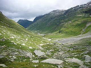
The Val Curciusa is an alpine valley in Graubünden, Switzerland. In the region of the San Bernardino Pass, it provides a connection between the Rheinwald valley and the Misox valley.
Heinzenberg is the western side of Hinterrhein valley in the Swiss canton of Graubünden between the Viamala and the narrow valley in Rothenbrunnen. The eastern side of the valley is called Domleschg. The region is named after the Heinzenberg Castle near the village of Präz.

The Val Vignun is an alpine valley in the Swiss Canton of Graubünden. It also forms a connection between the Misox valley and the Rheinwald valley, parallel to the San Bernardino Pass.

Mesocco Castle is a ruined castle in the municipality of Mesocco of the Canton of Graubünden in Switzerland. It is a Swiss heritage site of national significance.

The ruins of the former Splügen Castle lie east of the village of Splügen in the Rheinwald forest in the Swiss canton of Graubünden. It is the only castle in the valley.


