Domleschg | |
|---|---|
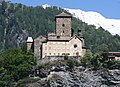
 Paspels village in Domleschg | |
 Flag  Coat of arms | |
Location of Domleschg  | |
 Domleschg  Domleschg | |
| Coordinates: 46°43′N9°26′E / 46.717°N 9.433°E | |
| Country | Switzerland |
| Canton | Grisons |
| District | Viamala |
| Government | |
| • Mayor | Gemeindepräsident Werner Natter |
| Area | |
• Total | 45.94 km2 (17.74 sq mi) |
| Elevation | 687 m (2,254 ft) |
| Population (31 December 2018) [2] | |
• Total | 2,063 |
| • Density | 45/km2 (120/sq mi) |
| Time zone | UTC+01:00 (Central European Time) |
| • Summer (DST) | UTC+02:00 (Central European Summer Time) |
| Postal code(s) | 7415-7418 |
| SFOS number | 3673 |
| ISO 3166 code | CH-GR |
| Surrounded by | Cazis, Fürstenau |
| Website | www SFSO statistics |
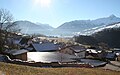
Domleschg is a municipality in the Viamala Region in the Swiss canton of the Grisons. On 1 January 2015 the former municipalities of Almens, Paspels, Pratval, Rodels and Tomils merged to form the new municipality of Domleschg. [3]