Lake Constance refers to three bodies of water on the Rhine at the northern foot of the Alps: Upper Lake Constance (Obersee), Lower Lake Constance (Untersee), and a connecting stretch of the Rhine, called the Seerhein. These waterbodies lie within the Lake Constance Basin in the Alpine Foreland through which the Rhine flows. The nearby Mindelsee is not considered part of Lake Constance. The lake is situated where Germany, Switzerland, and Austria meet. Its shorelines lie in the German states of Baden-Württemberg and Bavaria; the Swiss cantons of St. Gallen, Thurgau, and Schaffhausen; and the Austrian state of Vorarlberg. The actual locations of the country borders within the lake are disputed.

Vorarlberg is the westernmost state of Austria. It has the second-smallest geographical area after Vienna and, although it also has the second-smallest population, it is the state with the second-highest population density. Two thirds of the state are situated above 1,000m. It borders three countries: Germany, Switzerland, and Liechtenstein. The only Austrian state that shares a border with Vorarlberg is Tyrol, to the east.

The Grisons or Graubünden, more formally the Canton of the Grisons or the Canton of Graubünden, is one of the twenty-six cantons of Switzerland. It has eleven districts, and its capital is Chur. The German name of the canton, Graubünden, translates as the "Grey Leagues", referring to the canton's origin in three local alliances, the Three Leagues. The other native names also refer to the Grey League: Grischùn in Sutsilvan, Grischun in the other forms of Romansh, and Grigioni in Italian. Rhaetia is the Latin name for the area. The Alpine ibex is the canton's heraldic symbol.

Rail transport in Switzerland is noteworthy for the density of its network, its coordination between services, its integration with other modes of transport, timeliness and a thriving domestic and trans-Alp freight system. It is made necessary by strong regulations on truck transport, and is enabled by properly coordinated intermodal logistics.

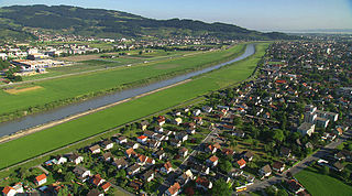
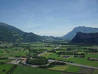
The Alpine Rhine Valley is a glacial alpine valley, formed by the Alpine Rhine, the part of the Rhine between the confluence of the Anterior Rhine and Posterior Rhine at Reichenau and Lake Constance. It covers three countries, with sections of the river demarcating the borders between Austria and Switzerland and between Liechtenstein and Switzerland. The full length of the Alpine Rhine is 93.5 km.

The canton of St. Gallen or St Gall is a canton of Switzerland. Its capital is St. Gallen.
Lustenau is a town in the westernmost Austrian state of Vorarlberg in the district of Dornbirn. It lies on the river Rhine, which forms the border with Switzerland. Lustenau is Vorarlberg's fourth largest town.

The Eastern Alps are usually defined as the area east of a line from Lake Constance and the Alpine Rhine valley, up to the Splügen Pass at the Alpine divide, and down the Liro River to Lake Como in the south. The peaks and mountain passes are lower than the Western Alps, while the range itself is broader and less arched.

Rheineck is a municipality in the Wahlkreis (constituency) of Rheintal in the canton of St. Gallen in Switzerland.

The United Swiss Railways was a former railway company in Switzerland. It was the smallest of the five main railways that were nationalised from 1902 to form the Swiss Federal Railways.

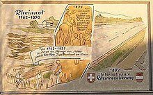
Vogtei Rheintal was a condominium of the Old Swiss Confederacy from the 15th century until 1798. Its territory corresponded to the left banks of the Alpine Rhine between Hoher Kasten and Lake Constance, including the towns of Altstätten and Rheineck.

The Obersee, also known as Upper Lake Constance, is the much larger of the two parts of Lake Constance, the other part being the Untersee. The two parts are separated by the Bodanrück peninsula. The narrow, northwestern branch of Obersee is also called Überlinger See.

The Alter Rhein is the old river bed of the Alpine Rhine in St. Gallen and Vorarlberg in the Alpine Rhine Valley, which was cut off when the Rhine was straightened during the 20th century. These cut-off arms have become valuable recreational areas and a nature reserve.
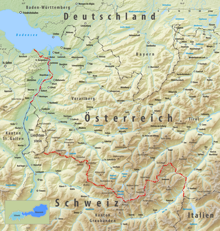
The border between the modern states of Austria and Switzerland is divided into two parts, separated by the Principality of Liechtenstein, with a total length of 180 km (110 mi). The longer, southern stretch runs across the Grison Alps and the shorter one following mostly the Alpine Rhine, except near Diepoldsau and between Lustenau and Lake Constance, where it follows the Old Rhine bed. The border continues northward to the Austrian-Swiss-German tripoint located within Upper Lake Constance.
The Saar is a minor tributary of the Alpine Rhine in the Swiss canton of St. Gallen. It rises in Mittelsäss, Bad Ragaz municipality, at 2,087 m elevation. Flowing generally north, it passes the Saarfall waterfall, dropping from 560 m to 500 m, reaching the plain of the Rhine Valley. From here, it is strongly canalised, flowing through the territories of the Vilters-Wangs, Mels and Sargans municipalities before joining the Rhine downstream of Trübbach at 480 m.

The Chur–Rorschach railway line, also called the Rhine Valley line, is a standard gauge railway line in Switzerland. It belongs to the Swiss Federal Railways (SBB) and is located in the cantons of St. Gallen and the Grisons.

Vorarlberg S-Bahn is a label for regional rail services in the westernmost Austrian state of Vorarlberg. The S-Bahn services also connect to stations in the German town of Lindau, the Swiss towns of St. Margrethen and Buchs, and the Principality of Liechtenstein.

The Rhine delta of Lake Constance is the river delta on the southeastern shore of Lake Constance, which the Rhine has formed in a former sea area. It lies mostly in the Austrian province of Vorarlberg, smaller areas are in the Swiss canton of St. Gallen. The two peninsulas in the lake are called Rheinspitz (west) and Rohrspitz (east).

Buchs SG railway station is a railway station in Buchs, in the Swiss canton of St. Gallen. It is an intermediate stop on the Chur–Rorschach line and western terminus of the Feldkirch–Buchs line to Austria and Liechtenstein. It is served by local and long-distance trains. As the station is located just north of the crossing of the Rhine between Switzerland and Liechtenstein, long-distance trains traveling between Zürich and points east must reverse direction.

The St. Margrethen–Lauterach line is a 9.580-kilometre (5.953 mi) long, part single part double tracked, electrified railway line in the Alpine Rhine Valley, near Lake Constance. The route is owned and operated by Austrian Federal Railways (ÖBB) and is mainly used by the border station in St. Margrethen.