
The Rhine is one of the major European rivers. The river begins in the Swiss canton of Graubünden in the southeastern Swiss Alps. It forms part of the Swiss-Liechtenstein border, then part of the Swiss-Austrian border. From Lake Constance downstream, it forms part of the Swiss-German border. After that the Rhine defines much of the Franco-German border. It then flows in a mostly northerly direction through the German Rhineland. Finally in Germany, the Rhine turns into a predominantly westerly direction and flows into the Netherlands where it eventually empties into the North Sea. It drains an area of 9,973 km2.

Upper Rhine is the section of the Rhine between the Middle Bridge in Basel, Switzerland, and the Rhine knee in Bingen, Germany. It is surrounded by the Upper Rhine Plain. Most of its upper section marks the France–Germany border.

Bingen am Rhein is a town in the Mainz-Bingen district in Rhineland-Palatinate, Germany.

Weil am Rhein is a German town and commune. It is on the east bank of the River Rhine, and extends to the tripoint of Switzerland, France, and Germany. It is the most southwesterly town in Germany and a suburb in the Trinational Eurodistrict of Basel. The town has around 30,000 inhabitants, and the Eurodistrict metropolitan area has about 830,000.

High Rhine is the section of the Rhine between Lake Constance and the city of Basel, flowing in a general east-to-west direction and forming mostly the Germany–Switzerland border. It is the first of four named sections of the Rhine between Lake Constance and the river delta at the North Sea.
The Wiese is a river, 57.8 kilometres long, and a right-hand tributary of the Rhine in southwest Germany and northwest Switzerland.
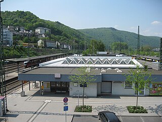
Bingen (Rhein) Hauptbahnhof is a railway station in the German city of Bingen am Rhein on the West Rhine Railway. It is located in the borough of Bingerbrück. The station that serves central Bingen is called Bingen Stadt.
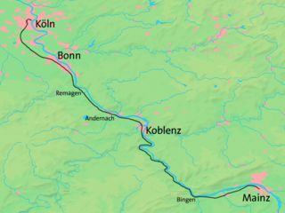
The West Rhine railway is a famously picturesque, double-track electrified railway line running for 185 km from Cologne via Bonn, Koblenz, and Bingen to Mainz. It is situated close to the western (left) bank of the river Rhine and mostly aligned to allow 160 km/h operation between Cologne and Koblenz and between Bingen and Mainz. Line speed between Koblenz and Bingen is restricted by the meandering nature of the Rhine Gorge, a UNESCO World Heritage Site.

The Wutach is a river, 91 kilometres long, in the southeastern part of the Black Forest in the German state of Baden-Württemberg. It is a right-hand tributary of the Rhine. In its lower reaches it flows for about 6 kilometres along the border with the canton of Schaffhausen, Switzerland.
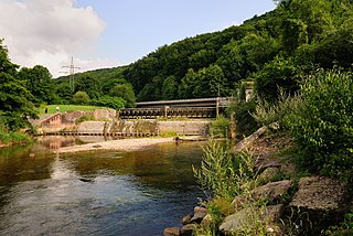
Manubach is an Ortsgemeinde – a municipality belonging to a Verbandsgemeinde, a kind of collective municipality – in the Mainz-Bingen district in Rhineland-Palatinate, Germany.

Köln Süd station is located in the southwestern edge of the Innenstadt of Cologne in the district of Neustadt-Süd in the German state of North Rhine-Westphalia. It is located between the streets of Luxemburger Straße and Zülpicher Straße. The station is a stop for regional services on the West Rhine Railway. The Cologne freight railway bypass branches off from the station over the South Bridge; it is also used as needed by passenger trains. The station has four platform tracks at two island platforms and two tracks without platforms, which are used by the intensive freight traffic. It is classified by Deutsche Bahn as a category 4 station.

The Untersee, also known as Lower Lake Constance, is the smaller of the two lakes that together form Lake Constance. The boundary between Switzerland and Germany runs through it. The lake surrounds several islands, the largest being Reichenau Island.

The Rhine romanticism was the interpretation of the landscape conditions and history of the Rhine Valley in the cultural-historical period of the romanticism, by the end of the 18th century until the late 19th century and was continued in all forms of art expression.

The Bingen Forest is part of the Hunsrück, a low mountain range in the Central Uplands of Germany. It is up to 638.6 m above sea level (NN) and is located in the state of Rhineland-Palatinate.

During the Battle of Kehl, a Republican French force under the direction of Jean Charles Abbatucci mounted an amphibious crossing of the Rhine River against a defending force of soldiers from the Swabian Circle. In this action of the War of the First Coalition, the French drove the Swabians from their positions in Kehl and subsequently controlled the bridgehead on both sides of the Rhine.

The border between the modern states of Germany and Switzerland extends to 362 kilometres (225 mi), mostly following Lake Constance and the High Rhine, with territories to the north mostly belonging to Germany and territories to the south mainly to Switzerland. Exceptions are the Swiss canton of Schaffhausen, the Rafzerfeld and hamlet of Nohl of the canton of Zürich, Bettingen and Riehen municipalities and part of the city of Basel in the canton of Basel-City and the old town of the German city of Konstanz, which is located south of the Seerhein. The canton of Schaffhausen is located almost entirely on the northern side of the High Rhine, with the exception of the southern part of the municipality of Stein am Rhein. The German municipality of Büsingen am Hochrhein is an enclave surrounded by Swiss territory.
A knee, or river knee, is a bend in a river changing its course greatly, suddenly to a different general direction. It is different from most (one-off) riverbends, and from a (particular) meander which connotes one of several bends in a sinuous course, without changing the general direction.

Weil am Rhein station is a small railway junction in Weil am Rhein in the German state of Baden-Württemberg on the German-Swiss border. The Weil am Rhein–Lörrach railway branches off the Mannheim–Karlsruhe–Basel railway at the station. From 1878 to 1937, the station was the starting point of the Weil am Rhein–Saint-Louis line to the French town of Saint-Louis.

