
The Upper Rhine is the section of the Rhine between the Middle Bridge in Basel, Switzerland, and the Rhine knee in Bingen, Germany. It is surrounded by the Upper Rhine Plain. Most of its upper section marks the France–Germany border.
Markgräflerland is a region in the southwest of Germany, in the south of the German federal state of Baden-Württemberg, located between the Breisgau in the north and the Black Forest in the east; adjacent to west with France and in the south with Switzerland.

The Battle of Friedlingen took place on 14 October 1702, during the War of the Spanish Succession. Most of the fighting centred around Friedlingen, now a suburb of Weil am Rhein, on the current border between Baden-Württemberg in Germany, and Switzerland. A French force under Villars defeated an Imperial army commanded by Louis William, Margrave of Baden-Baden.
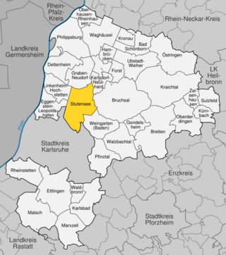
Stutensee is a town in northern Karlsruhe district in Baden-Württemberg, Germany.
Binzen is a municipality in the southwestern German Federal State of Baden-Württemberg, part of the district Lörrach. The town's coat of arms was granted on 29 August 1967. The blazon of the arms is Azure a Garb Or on a Chief Gules a Rising Sun in Splendour Or. The town is the seat of the municipal administrative association Vorderes Kandertal.

High Rhine is the name of the part of the Rhine between Lake Constance and the city of Basel, flowing in a general east-to-west direction and forming mostly the Germany–Switzerland border. It is the first of four named sections of the Rhine between Lake Constance and the river delta at the North Sea.

Neuenburg am Rhein is a town in the district Breisgau-Hochschwarzwald in Baden-Württemberg in southern Germany.

The Kander is a small river flowing from the southern Black Forest westward into the Rhine.

The Grand Duchy of Baden was an independent state in what is now southwestern Germany until the creation of the German Empire in 1871. It had its own state-owned railway company, the Grand Duchy of Baden State Railways, which was founded in 1840. At the time when it was integrated into the Deutsche Reichsbahn in 1920, its network had an overall length of about 2,000 kilometres (1,200 mi).

The Baden main line is a German railway line that was built between 1840 and 1863. It runs through Baden, from Mannheim via Heidelberg, Karlsruhe, Offenburg, Freiburg, Basel, Waldshut, Schaffhausen and Singen to Konstanz. The Baden Mainline is 412.7 kilometres long, making it the longest route in the Deutsche Bahn network and also the oldest in southwest Germany. The section between Mannheim and Basel is the most important northern approach to the Swiss Alpine passes, whilst the section between Basel and Konstanz is only of regional significance. The stretch from Karlsruhe to Basel is also known as the Rhine Valley Railway (Rheintalbahn) and the Basel–Konstanz section as the High Rhine Railway (Hochrheinstrecke).

The Mannheim–Karlsruhe–Basel railway is a double-track electrified mainline railway in the German state of Baden-Württemberg. It runs from Mannheim via Heidelberg, Bruchsal, Karlsruhe, Rastatt, Baden-Baden, Offenburg and Freiburg to Basel, Switzerland. It is also known as the Rhine Valley Railway or the Upper Rhine Railway (Oberrheinbahn).

The Weil am Rhine–Lörrach railway, also known as the Gartenbahn, is a 4.836 km long electrified, single-track main line railway in the German state of Baden-Württemberg, near Basel. It runs from Weil am Rhein on the Rhine Valley Railway through Tüllinger Berg to Lörrach-Stetten on the Wiese Valley Railway. The continuation of the former bypass of Switzerland was the now disused Wehra Valley Railway from a branch near Schopfheim on the Wiese Valley Railway to Bad Säckingen on the High Rhine Railway (Hochrheinbahn).

The border between the modern states of Germany and Switzerland extends to 362 kilometres (225 mi), mostly following Lake Constance and the High Rhine, with territories to the north mostly belonging to Germany and territories to the south mainly to Switzerland. Exceptions are the Swiss canton of Schaffhausen, the Rafzerfeld and hamlet of Nohl of the canton of Zürich, Bettingen and Riehen municipalities and part of the city of Basel in the canton of Basel-City and the old town of the German city of Konstanz, which is located south of the Seerhein. The canton of Schaffhausen is located almost entirely on the northern side of the High Rhine, with the exception of the southern part of the municipality of Stein am Rhein. The German municipality of Büsingen am Hochrhein is an enclave surrounded by Swiss territory.
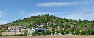
Tüllingen is a part of Lörrach, Baden-Württemberg, Germany. It is located on Tüllinger Mountain, which is also known as Tüllinger Hill or simply the Tüllinger. Upper and Lower Tüllingen were merged into the Tüllingen district in 1935.

Weil am Rhein station is a small railway junction in Weil am Rhein in the German state of Baden-Württemberg on the German-Swiss border. The Weil am Rhein–Lörrach railway branches off the Mannheim–Karlsruhe–Basel railway at the station. From 1878 to 1937, the station was the starting point of the Weil am Rhein–Saint-Louis line to the French town of Saint-Louis.

The Karlsruhe–Basel high-speed railway is a new line being built on the route of the Mannheim–Karlsruhe–Basel railway. As a result of the project, the railway through the Rhine Valley is being upgraded to four continuous tracks and its operational efficiency will be increased as a result of the segregation of the various transport flows. The travel time for passenger services between Karlsruhe and Basel is to be shortened by 31 minutes. The project forms part of the Rotterdam–Genoa corridor and part of it is also part of the Main line for Europe. In September 2010, it was forecast to be completed in 2020.

Haltingen station is a railway station in the town of Weil am Rhein, in Baden-Württemberg, Germany. It is located on the Mannheim–Karlsruhe–Basel railway of Deutsche Bahn. The Kander Valley Railway heritage railway operates from a platform just north of the station.
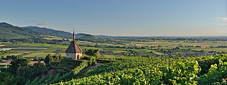
The Tüllinger Berg short form Tüllinger, also known as Tüllinger Hügel in Switzerland, is a partly forested mountain located at an elevation of 460.2 m above sea level. It is situated in the southwest of Baden-Württemberg, at the border triangle of Germany, France, and Switzerland. The mountain extends about two kilometers from east to west and about five kilometers from north to south, forming a natural border between the urban areas of Lörrach and Weil am Rhein. Notably, the Tüllinger Berg is characterized by the break-off edge of the high strand of the Rhine Valley and the meadow floodplain. The slope of the Tüllinger Berg, especially with its western mountain nose, defines the surrounding landscape. The border between Germany and Switzerland runs along the southeastern foothills of the mountain.

Ötlingen is a Stadtteil and Ortschaft of Weil am Rhein, Baden-Württemberg, Germany. It is located on the northwestern foothills of the Tüllinger Berg. Once an independent community, this area was incorporated into Weil am Rhein in 1971.


