
South Georgia and the South Sandwich Islands (SGSSI) is a British Overseas Territory in the southern Atlantic Ocean. It is a remote and inhospitable collection of islands, consisting of South Georgia and a chain of smaller islands known as the South Sandwich Islands. South Georgia is 165 kilometres (103 mi) long and 35 kilometres (22 mi) wide and is by far the largest island in the territory. The South Sandwich Islands lie about 700 kilometres (430 mi) southeast of South Georgia. The territory's total land area is 3,903 km2 (1,507 sq mi). The Falkland Islands are about 1,300 kilometres (810 mi) west from its nearest point.

The British Antarctic Territory (BAT) is a sector of Antarctica claimed by the United Kingdom as one of its 14 British Overseas Territories, of which it is by far the largest by area. It comprises the region south of 60°S latitude and between longitudes 20°W and 80°W, forming a wedge shape that extends to the South Pole, overlapped by the Antarctic claims of Argentina and Chile. The claim to the region has been suspended since the Antarctic Treaty came into force in 1961.
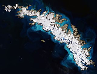
South Georgia is an island in the South Atlantic Ocean that is part of the British Overseas Territory of South Georgia and the South Sandwich Islands. It lies around 1,400 kilometres (870 mi) east of the Falkland Islands. Stretching in the east–west direction, South Georgia is around 170 kilometres (106 mi) long and has a maximum width of 35 kilometres (22 mi). The terrain is mountainous, with the central ridge rising to 2,935 metres (9,629 ft) at Mount Paget. The northern coast is indented with numerous bays and fjords, serving as good harbours.

The South Orkney Islands are a group of islands in the Southern Ocean, about 604 km (375 mi) north-east of the tip of the Antarctic Peninsula and 844 km (524 mi) south-west of South Georgia Island. They have a total area of about 620 km2 (240 sq mi). The islands are claimed both by Britain, and by Argentina as part of Argentine Antarctica. Under the 1959 Antarctic Treaty, sovereignty claims are held in abeyance.
The Support Force Glacier is a major glacier in the Pensacola Mountains, draining northward between the Forrestal Range and Argentina Range to the Filchner-Ronne Ice Shelf.

Palmer Archipelago, also known as Antarctic Archipelago, Archipiélago Palmer, Antarktiske Arkipel or Palmer Inseln, is a group of islands off the northwestern coast of the Antarctic Peninsula. It extends from Tower Island in the north to Anvers Island in the south. It is separated by the Gerlache and Bismarck straits from the Antarctic Peninsula and Wilhelm Archipelago, respectively. The archipelago is in the British, Chilean, and Argentine Claims.
Northeast Glacier is a steep, heavily crevassed glacier, 13 nautical miles long and 5 nautical miles wide at its mouth, which flows from McLeod Hill westward and then south-westwards into Marguerite Bay between the Debenham Islands and Roman Four Promontory, on the west coast of Graham Land, Antarctica.

Trinity Island or Île de la Trinité or Isla Trinidad is an island 24 km (15 mi) long and 10 km (6 mi) wide in the northern part of the Palmer Archipelago, Antarctica. It lies 37 km (23 mi) east of Hoseason Island, 72.6 km (45 mi) south of Deception Island in the South Shetland Islands, and 10.3 km (6 mi) north-northwest of Cape Andreas on the Antarctic Peninsula. The island was named by Otto Nordenskiöld, leader of the 1901-1904 Swedish Antarctic Expedition (SAE) in commemoration of Edward Bransfield's "Trinity Land" of 1820.

Snow Hill Island is an almost completely snowcapped island, 33 km (21 mi) long and 12 km (7.5 mi) wide, lying off the east coast of the Antarctic Peninsula. It is separated from James Ross Island to the north-east by Admiralty Sound and from Seymour Island to the north by Picnic Passage. It is one of several islands around the peninsula known as Graham Land, which is closer to Chile, Argentina and South America than any other part of the Antarctic continent.

Betws yn Rhos is a village and community in Conwy County Borough, Wales.

The Argentine Islands are a group of islands in the Wilhelm Archipelago of Antarctica, situated 9 km (5 nmi) southwest of Petermann Island, and 7 km (4 nmi) northwest of Cape Tuxen on Kyiv Peninsula in Graham Land. They were discovered by the French Antarctic Expedition, 1903–05, under Jean-Baptiste Charcot, and named by him for the Argentine Republic, in appreciation of that government's support of his expedition.
The Melchior Islands are a group of many low, ice-covered islands lying near the center of Dallmann Bay between Brabant Island and Anvers Island in the Palmer Archipelago, Antarctica. They were first seen but left unnamed by a German expedition under Eduard Dallmann, 1873–74. The islands were resighted and roughly charted by the Third French Antarctic Expedition under Jean-Baptiste Charcot, 1903–05.

Lambda Island is an island lying immediately north-west of Delta Island in the Melchior Islands, of the Palmer Archipelago in Antarctica. The island, the largest in the north-western part of the island group, was first roughly charted and named "Île Sourrieu" by the French Antarctic Expedition, 1903–05 under Jean-Baptiste Charcot, but that name has not survived in usage. The current name, derived from lambda, the 11th letter of the Greek alphabet, was given by Discovery Investigations personnel who roughly charted the island in 1927. The island was surveyed by Argentine expeditions in 1942, 1943 and 1948.

Argentina Glacier is a glacier flowing northwest from Hurd Dome and terminating near Argentina Cove, South Bay, on Livingston Island, in the South Shetland Islands. The name Argentina Glacier was given in association with Argentina Cove by the Spanish Antarctic Expedition, about 1995.

Jenner Glacier is a glacier 3 nautical miles (6 km) long flowing southwest from the Solvay Mountains between Paprat Peak and Kondolov Peak into the eastern arm of Duperré Bay, in the southern part of Brabant Island in the Palmer Archipelago, Antarctica.
Koch Glacier is a glacier 3 nautical miles (6 km) long immediately east of Jenner Glacier on the south side of Brabant Island, in the Palmer Archipelago, Antarctica. It drains the south slopes of Solvay Mountains and flows south-southwestwards into Chiriguano Bay southeast of Paprat Peak.
Paré Glacier is a glacier 7 nautical miles (13 km) long and 1 nautical mile (1.9 km) wide, draining the northeast slopes of Stribog Mountains, and flowing east and then northeast into the head of Bouquet Bay on the northeast side of Brabant Island in the Palmer Archipelago, Antarctica.
Hippocrates Glacier is a glacier at least 3 nautical miles (6 km) long and 2 nautical miles (4 km) wide, draining the southeast slopes of Stribog Mountains and flowing southeast between Solvay Mountains and Gutsal Ridge into Buls Bay on the east side of Brabant Island, in the Palmer Archipelago, Antarctica. It was shown on an Argentine government chart in 1953, but not named. The glacier was photographed by Hunting Aerosurveys Ltd in 1956–57, and mapped from these photos in 1959. It was named by the UK Antarctic Place-Names Committee for Hippocrates, a Greek physician and author of numerous works on medicine, who also established a professional code of medical conduct.
Rush Glacier is a glacier in Antarctica. Situated in southern Brabant Island, it is 4 nautical miles (7 km) long, draining the northwest slopes of Solvay Mountains and flowing west between Mount Aciar and Mount Sarnegor into the Buragara Cove of Dallmann Bay in the Palmer Archipelago. It was shown on an Argentine government chart in 1953, but not named. It was photographed by Hunting Aerosurveys Ltd in 1956–57, and mapped from these photos in 1959. The glacier was named by the United Kingdom Antarctic Place-Names Committee (UK-APC) for Benjamin Rush (1745–1813), a noted American physician and philanthropist, and a signatory of the Declaration of Independence.
Lister Glacier is a glacier 5 nautical miles (9 km) long and 1 nautical mile (2 km) wide, draining the northeast slopes of Stribog Mountains and flowing into Bouquet Bay just south of Duclaux Point on the northeast side of Brabant Island, in the Palmer Archipelago, Antarctica.

