
Freguesia, usually translated as "parish" or "civil parish", is the third-level administrative subdivision of Portugal, as defined by the 1976 Constitution. It is also a local administrative unit in the former Portuguese overseas territories of Cape Verde and Macau. In the past, was also an administrative division of the other Portuguese overseas territories. The parroquia in the Spanish autonomous communities of Galicia and Asturias is similar to a freguesia.

Alcoutim is a town and a municipality in southeastern Portugal near the border with Spain. The population in 2011 was 2,917, in an area of 575.36 km². It is the least densely populated municipality in Portugal. The municipality is limited on the north by Mértola Municipality, on the east by Huelva Province in Spain, on the southeast by Castro Marim Municipality, on the southwest by Tavira Municipality and on the west by Loulé Municipality and Almodôvar Municipality. The administrative center is the town of Alcoutim, located at the extreme eastern part of the municipality on the Spanish frontier, just across the Guadiana River from the Spanish town of Sanlúcar de Guadiana in Huelva Province.

Anadia is a municipality in Portugal. The population in 2011 was 29,150, in an area of 216.63 km². It had 26,915 eligible voters. The city of Anadia is part of Arcos e Mogofores parish. The city itself had a population of 3,034 in 2001, while Arcos e Mogofores parish has about 5,000.

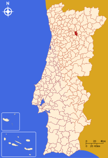
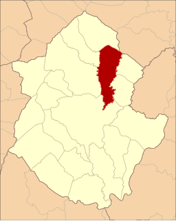
Carrazeda de Ansiães is a municipality in the district of Bragança in northern Portugal. The population in 2011 was 6,373, in an area of 279.24 km2.

Alenquer is a municipality in the Oeste Subregion in Portugal. The population in 2011 was 43,267, in an area of 304.22 km². The present Mayor is Jorge Riso, elected by the Socialist Party.

São João da Pesqueira is a municipality and municipal seat in the Portuguese district of Viseu. The population of the municipality in 2011 was approximately 7,874 inhabitants, in an area that extends 266.11 square kilometres (102.75 sq mi). The present mayor is Manuel Cordeiro, elected by a citizens' movevent. The municipal holiday is June 24.
Tabuaço is a municipality in the district Viseu in Portugal. The population in 2011 was 6,350, in an area of 133.86 km².

Areias de Vilar e Encourados is a civil parish in the municipality of Barcelos, Portugal. It was formed in 2013 by the merger of the former parishes Areias de Vilar and Encourados. The population in 2011 was 1,879, in an area of 10.17 km².

Milhazes, Vilar de Figos e Faria is a civil parish in the municipality of Barcelos, Portugal. It was formed in 2013 by the merger of the former parishes Milhazes, Vilar de Figos and Faria. The population in 2011 was 2,066, in an area of 12.14 km².
Alcoutim is a former civil parish, located in the municipality of Alcoutim, Algarve, Portugal. In 2013, the parish merged into the new parish Alcoutim e Pereiro.
Alcoutim e Pereiro is a civil parish in the municipality of Alcoutim, Algarve, Portugal. It was formed in 2013 by the merger of the former parishes Alcoutim and Pereiro. The population in 2011 was 1,134, in an area of 231.17 km².
Agrobom is a former civil parish, located in the municipality of Alfândega da Fé, in northern Portugal. In 2013, the parish merged into the new parish Agrobom, Saldonha e Vale Pereiro. It has less than 150 inhabitants in an area of 14.97 km² against the flank of the Serra de Bornes.

Luis Ángel Sánchez Pereiro alias Lois Pereiro was a Galician poet and writer.
Agrobom, Saldonha e Vale Pereiro is a civil parish in the municipality of Alfândega da Fé, Portugal. It was formed in 2013 by the merger of the former parishes Agrobom, Saldonha and Vale Pereiro. The population in 2011 was 265, in an area of 32.60 km².
The Menhirs of Lavajo are a group of menhirs, located in the civil parish of Alcoutim e Pereiro in the municipality of Alcoutim, Portuguese Algarve.

The Quinta da Ribafria is situated close to Sintra in Lisbon District, Portugal. It was built from 1536 to 1541 by Gaspar Gonçalves, a ceremonial official of the Portuguese Royal Household, on land donated to him by King Manuel I in 1515. The property is now owned by the Sintra Municipality.
