The Lisbon Metropolitan Area is a metropolitan area in Portugal centered on Lisbon, the capital and largest city of the country. The metropolitan area, covering 17 cities in 18 municipalities, is the largest urban area in the country and the 10th largest in the European Union, with a population in 2015 of 2,812,678 in an area of 3,015.24 km².
The Santarém Football Association is the district governing body for the all football competitions in the Portuguese district of Santarém. It is also the regulator of the clubs registered in the district.

Almeirim is a city and a municipality in Santarém District, Portugal. The population in 2011 was 23,376, in an area of 222.12 km2. The city proper had a population of 10,520 in 2001.

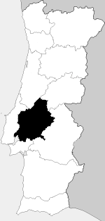
The District of Santarém is a district of Portugal, located in Portugal's Centro Region. The district capital is the city of Santarém.

Abrantes is a municipality in the central Médio Tejo subregion of Portugal. The population as of 2011 was 39,325, in an area of 714.69 square kilometres (275.94 sq mi). The municipality includes several parishes divided by the Tagus River, which runs through the middle of the municipality. The urbanized part, the parish of Abrantes e Alferrarede, located on the north bank of the Tagus, has about 17,000 residents.
Alpiarça is a municipality in Santarém District in Portugal. The population in 2011 was 7,702, in an area of 95.36 km2.

Entroncamento is a Portuguese municipality in district of Santarém in the Médio Tejo Subregion of the Centro Region. The population in 2011 was 20,206, in an area of 13.73 km2. Situated in the Ribatejo, it benefits from its geo-strategic position along the Tagus Valley, with important accessibility to the motorways and railway lines that historically promoted its growth and expansion.

Azambuja is a municipality in the Portuguese district of Lisbon, in the historical region of Ribatejo. The population in 2011 was 21,814, in an area of 262.66 km2. Since 2002, it was integrated into the NUTS III statistical subregion of Lezíria do Tejo.

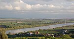
The Comunidade Intermunicipal da Lezíria do Tejo is an administrative division in Portugal. It was established as an Associação de Municípios in 1987, converted into a Comunidade Urbana in 2003, and converted into a Comunidade Intermunicipal in November 2008. It is also a NUTS3 subregion of the Oeste e Vale do Tejo. The seat of the intermunicipal community is the city of Santarém. Lezíria do Tejo comprises municipalities of the former districts of Santarém and Lisbon. The population in 2011 was 247,453, in an area of 4,275 square kilometres (1,651 sq mi). In the past, the territory of this administrative division was roughly entirely set in the historic province of Ribatejo and had nothing to do with the historic province of Alentejo. Lezíria is the Portuguese word for floodplain or freshwater marsh. Tejo is the name of the main river in the region. The Lezíria is a well-renowned center of intensive farming, horse breeding and animal husbandry.

Rodoviária do Tejo, S.A. is a regional bus company in Portugal.
Tejo, until 2009 named Ribatejo, is a Portuguese wine region covering the same areas as the Ribatejo Province. It takes its name from the river Tejo (Tagus). The entire region is entitled to use the Vinho Regional designation Tejo VR, while some areas are also classified at the higher Denominação de Origem Controlada (DOC) level under the designation DoTejo DOC. VR is similar to the French vin de pays and DOC to the French AOC.

The term "provinces" has been used throughout history to identify regions of continental Portugal. Current legal subdivisions of Portugal do not coincide with the provinces, but several provinces, in their 19th- and 20th-century versions, still correspond to culturally relevant, strongly self-identifying categories. They include:

The Oeste e Vale do Tejo is a NUTS II statistical region of Portugal. Bordered to the north by the Centro region, to the south by Alentejo, and to the west by the Atlantic Ocean. The Oeste and Vale do Tejo subregion has 34 municipalities. It was created in 2024 from parts of the Centro and Alentejo regions.