Ribera, Agrigento

Last updated
Ribera
Comune di Ribera
Panorama Ribera.jpg
Panorama of Ribera
Ribera-Stemma.png
Location of Ribera
Ribera, Agrigento
Italy provincial location map 2016.svg
Red pog.svg
Ribera
Location of Ribera in Italy
Italy Sicily location map.svg
Red pog.svg
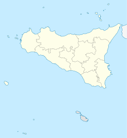
Ribera
Ribera (Sicily)
Coordinates: 37°29′58″N13°15′54″E / 37.49944°N 13.26500°E / 37.49944; 13.26500
Country Italy
Region Sicily
Province Agrigento (AG)
Frazioni Borgo Bonsignore, Seccagrande
Government
  MayorMatteo Ruvolo
Area
[1]
  Total
118.52 km2 (45.76 sq mi)
Elevation
223 m (732 ft)
Population
 (31 August 2022) [2]
  Total
17,757
  Density150/km2 (390/sq mi)
Demonym Riberesi
Time zone UTC+1 (CET)
  Summer (DST) UTC+2 (CEST)
Postal code
92016
Dialing code 0925
Patron saintSt. Nicholas
Saint dayDecember 6
Website Official website

Ribera (Sicilian: Rivela) is a comune in the province of Agrigento, Region of Sicily, southern Italy, between the Verdura and Magazzolo valleys in the so-called Plain of San Nicola.

Contents

The town is connected by the SS115 state road, leading from Trapani to Syracuse. The Platani River, the third Sicilian river, flows nearby. It has enormously contributed to developing both farming and tourism in the area. Its mouth has been designated as a natural reserve.

A Tower of Castello di Poggio Diana. Ribera torre poggiodiana.jpg
A Tower of Castello di Poggio Diana.

History

The comune probably rose on the site of the ancient Allava, to which the Byzantine necropolis near the modern town may possibly be attributed. In 1627, Luigi Guglielmo Moncada, Prince of Paternò, founded a new centre named after his wife, Maria Alfan di Ribera; the new centre developed rapidly, thanks to the fertility of the soil and the accessibility of the area.

It is the birthplace of Prime Minister Francesco Crispi.

Main sights

Sights include:

Just outside the town, on a gorge overlooking the Verdura river is the Castello di Poggio Diana, built by Guglielmo Peralta in the 14th century. A Bronze Age necropolis (13th century BC), the Anguilla necropolis, was discovered near the town. It includes some 30 tombs in two types, "chamber"- or "grotto"-like; some are preceded by a corridor up to 4 metres (13 ft) long.

Also outside the town is the Borgo Bonsignore, a village founded under Fascism as part of the "colonization" policy that encouraged the creation of new villages; it has now grown as a summer resort.

Economy

Agriculture is the commune's main industry, notably involved in the cultivation and marketing of the Washington navel orange – here introduced by emigrants returned from the United States – and strawberries. Such businesses are enhanced both by excellent climatic and environmental conditions and a supporting policy by the local authorities.

Twin towns

See also


  1. "Superficie di Comuni Province e Regioni italiane al 9 ottobre 2011". Italian National Institute of Statistics. Retrieved 16 March 2019.
  2. "Popolazione Residente al 1° Gennaio 2018". Italian National Institute of Statistics. Retrieved 16 March 2019.