Prince Edward County is located in the Commonwealth of Virginia. As of the 2020 census, the population was 21,849. Its county seat is Farmville.

Petersburg is an independent city in the Commonwealth of Virginia in the United States. As of the 2020 census, the population was 33,458 with a majority black American population. The Bureau of Economic Analysis combines Petersburg with Dinwiddie County for statistical purposes. The city is 21 miles (34 km) south of the commonwealth (state) capital city of Richmond.

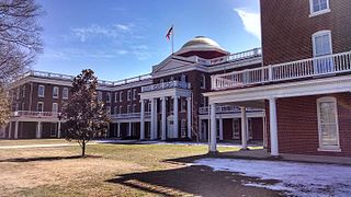
Farmville is a town in Prince Edward and Cumberland counties in the Commonwealth of Virginia. It is the county seat of Prince Edward County. The population was 7,473 at the 2020 census. It was in a major tobacco growing area. Coal mining and brick making also occurred in the area.

The Appomattox Court House National Historical Park is the preserved 19th-century village named Appomattox Court House in Appomattox County, Virginia. The village was named for the presence nearby of what is now preserved as the Old Appomattox Court House. The village is the site of the Battle of Appomattox Court House, and contains the McLean House, where the surrender of the Army of Northern Virginia under Robert E. Lee to Union commander Ulysses S. Grant took place on April 9, 1865, an event widely symbolic of the end of the American Civil War. The village itself began as the community of Clover Hill, which was made the county seat of Appomattox County in the 1840s. The village of Appomattox Court House entered a stage of decline after it was bypassed by a railroad in 1854. In 1930, the United States War Department was authorized to erect a monument at the site, and in 1933 the War Department's holdings there was transferred to the National Park Service. The site was greatly enlarged in 1935, and a restoration of the McLean House was planned but was delayed by World War II. In 1949, the restored McLean House was reopened to the public. Several restored buildings, as well as a number of original 19th-century structures are situated at the site.
The Southside Railroad was formed in Virginia in 1846. Construction was begun in 1849 and completed in 1854. The 5 ft gauge railroad connected City Point, a port on the James River with the farm country south and west of Petersburg, Virginia, to Lynchburg, Virginia, a distance of about 132 miles (212 km).

The Battle of Sailor's Creek was fought on April 6, 1865, near Farmville, Virginia, as part of the Appomattox Campaign, near the end of the American Civil War. It was the last major engagement between the Confederate Army of Northern Virginia, commanded by General Robert E. Lee, and the Army of the Potomac, under the overall direction of Union General-in-Chief Lieutenant General Ulysses S. Grant.
The Battle of Namozine Church was an engagement in Amelia County, Virginia, between Union Army and Confederate States Army forces that occurred on April 3, 1865, during the Appomattox Campaign of the American Civil War. The battle was the first engagement between units of General Robert E. Lee's Confederate Army of Northern Virginia after that army's evacuation of Petersburg and Richmond, Virginia, on April 2, 1865, and units of the Union Army under the immediate command of Maj. Gen. Philip Sheridan, who was still acting independently as commander of the Army of the Shenandoah, and under the overall direction of Union General-in-Chief Lt. Gen. Ulysses S. Grant. The forces immediately engaged in the battle were brigades of the cavalry division of Union Brig. Gen. and Brevet Maj. Gen. George Armstrong Custer, especially the brigade of Colonel and Brevet Brig. Gen. William Wells, and the Confederate rear guard cavalry brigades of Brig. Gen. William P. Roberts and Brig. Gen. Rufus Barringer and later in the engagement, Confederate infantry from the division of Maj. Gen. Bushrod Johnson.

The Tri-Cities of Virginia is an area in the Greater Richmond Region which includes the three independent cities of Petersburg, Colonial Heights, and Hopewell and portions of the adjoining counties of Chesterfield, Dinwiddie, and Prince George in south-central Virginia. Other unincorporated communities located in the Tri-Cities area include Ettrick, Fort Gregg-Adams, and City Point, the latter formerly a historic incorporated town which was annexed to become part of the City of Hopewell.

The Battle of Cumberland Church was fought on April 7, 1865, between the Union Army's II Corps of the Army of the Potomac and the Confederate Army of Northern Virginia during the Appomattox Campaign of the American Civil War.
The Battle of Appomattox Station was fought between a Union Army cavalry division under the command of Brigadier General George Armstrong Custer and Confederate Army of Northern Virginia artillery units commanded by Brigadier General Lindsay Walker with support from some dismounted cavalrymen, artillerymen armed with muskets and some stragglers on April 8, 1865, at Appomattox Station, Virginia during the Appomattox Campaign of the American Civil War.

The Battle of High Bridge refers to two engagements fought on April 6, 1865, and April 7, 1865, near the end of the Appomattox Campaign of the American Civil War about 4 miles (6.4 km) northeast of Farmville, Virginia. The first battle is often the one identified as the Battle of High Bridge.
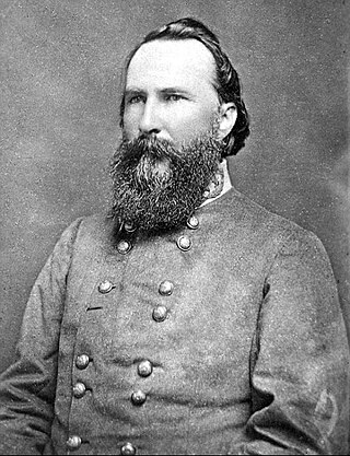
The Battle of Rice's Station was a minor engagement in Appomattox Campaign of the American Civil War that was fought at the same time as the Battle of Sailor's Creek on April 6, 1865. In the early morning of April 6, Confederate Lieutenant General James Longstreet's command reached Rice's Station, Virginia on the South Side Railroad. As Longstreet's corps was the first to reach Rice's Station after Lee moved his army west from Amelia Springs, Virginia, they awaited the remainder of the army, most of which ended up being delayed at the Battle of Sailor's Creek.
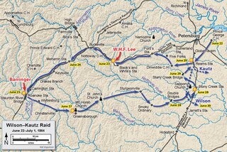
The Battle of Sappony Church, also known as the Battle of Stony Creek Depot, was an engagement of the American Civil War, between the Confederate States of America and the Union, which took place on June 28, 1864, during the Wilson-Kautz Raid of the Richmond–Petersburg Campaign.

High Bridge is a historic former railroad bridge across the Appomattox River valley about 6 miles (9.7 km) east, or downstream, of the town of Farmville in Prince Edward County, Virginia. The remains of the bridge and its adjacent rail line are now a rail trail park, High Bridge Trail State Park.
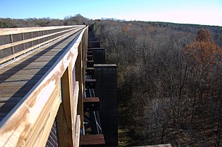
High Bridge Trail State Park is a rail trail in Southside Virginia converted from a rail line last belonging to Norfolk Southern.

Sayler's Creek Battlefield, near Farmville, Virginia, was the site of the Battle of Sayler's Creek of the American Civil War. Confederate general Robert E. Lee's army was retreating from the Richmond to the Petersburg line. Here, on April 6, 1865, Union general Philip Sheridan cut off and beat back about a quarter of Lee's depleted army. Eight Confederate generals surrendered, and 7,700 men were lost. Confederate Major General George Washington Custis Lee, eldest son of Robert E. Lee, was forcibly captured on the battlefield by Private David Dunnels White of the 37th Massachusetts Regiment. The battle was the last major engagement of the war in Virginia; Lee's surrender at Appomattox occurred three days later. A portion of the landmarked battlefield area is included in Sailor's Creek Battlefield Historical State Park. The Civil War Trust and its partners have acquired and preserved 885 acres (3.58 km2) of the battlefield in five transactions since 1996.

Sailor's Creek Battlefield Historical State Park is a 379-acre (153 ha) state park near Rice, Virginia, located mostly in Amelia County with a small portion in Prince Edward County. It includes a portion of the landmarked Sayler's Creek Battlefield, an area of 1,022 acres (414 ha) that was the site of the April 6, 1865 Battle of Sayler's Creek, one of the last major engagements in the Eastern Theater of the war involving Confederate General-in-Chief Robert E. Lee (1807–1870). The battle occurred during his week-long retreat to the southwest in the final Appomattox campaign from the fallen Confederate capital at Richmond and nearby Petersburg, three days before his surrender at Appomattox Court House to Union Army General-in-Chief Ulysses S. Grant (1822–1885), which effectively ended the American Civil War (1861–1865).
The 18th Virginia Infantry Regiment was an infantry regiment raised in Virginia for service in the Confederate States Army during the American Civil War. It fought mostly with the Army of Northern Virginia.

Gills is a rural unincorporated community in Amelia County in the U.S. state of Virginia. It is located in Leigh District around the intersections of SR 616 with SR 657, 1 mile (1.6 km) north of the Nottoway county line. Gills is situated at the highest point in Amelia County, 527 feet (161 m) above sea level, and is also the westernmost extant hamlet in the county. A portion of the segment of U.S. Bicycle Route 1 that runs southwest from Richmond follows SR 616 through Gills.

Mannboro is a rural unincorporated community in eastern Amelia County in the U.S. state of Virginia. It is located along SR 612 at its split and curve junctions with SR 708.


