
Gernrode is a historic town and former municipality in the Harz District, in Saxony-Anhalt, Germany. Since 1 January 2014, it has been part of Quedlinburg. It was the seat of the former Verwaltungsgemeinschaft of Gernrode/Harz.

Ilsenburg is a town in the district of Harz, in Saxony-Anhalt in Germany. It is situated under the north foot of the Harz Mountains, at the entrance to the Ilse valley with its little river, the Ilse, a tributary of the Oker, about six 6 miles (9.7 km) north-west of the town of Wernigerode. It received town privileges in 1959. Owing to its surrounding of forests and mountains as well as its position on the edge of the Harz National Park, Ilsenburg is a popular tourist resort. Since 2002, it is officially an air spa.

Alexisbad is a small spa town, part of Harzgerode in the district of Harz, Saxony-Anhalt, Germany.

Blankenburg (Harz) is a town and health resort in the district of Harz in Saxony-Anhalt, Germany, at the north foot of the Harz Mountains, 12 miles (19 km) southwest of Halberstadt.

Benneckenstein is a town in the district of Harz, in Saxony-Anhalt, Germany. Since 1 January 2010, it has been part of the town of Oberharz am Brocken. Benneckenstein is in the eastern Harz, 14 km southeast of Braunlage, and 24 km south of Wernigerode. Its population is 1,698 (2021).

Hasselfelde is a town in the district of Harz, in Saxony-Anhalt, Germany. It is in the eastern Harz, approximately 17 km south of Wernigerode. Since 1 January 2010 it has been part of the town of Oberharz am Brocken. Its population is 1,941 (2021).
Stecklenberg is a village and a former municipality in the district of Harz, in Saxony-Anhalt, Germany. Since 23 November 2009, it is part of the town Thale.
Gernrode/Harz was a Verwaltungsgemeinschaft in the district of Harz, in Saxony-Anhalt, Germany. The seat of the Verwaltungsgemeinschaft was Gernrode. Between 1 January 2011 and 19 February 2013 it was disbanded as its members temporarily became part of the town Quedlinburg. It was finally disbanded in January 2014.

The Harzer Wandernadel is a system of hiking awards in the Harz mountains in central Germany. Hikers can earn awards at different levels of challenge by walking to the various checkpoints in the network and stamping their passbooks to record the visit. With 222 checkpoints in three federal states and across five districts in the Harz and with membership in five figures, the system has gained a following Germany-wide.
Trautenstein is a village in the borough of Oberharz am Brocken in the district of Harz in the German state of Saxony-Anhalt. Formerly an independent municipality, it was merged into the town Hasselfelde in 2002, which was merged into Oberharz am Brocken in 2010. Its population is 390 (2021).
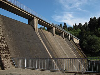
The Hassel Auxiliary Dam or Hassel Dam is an auxiliary dam or pre-dam on the Rappbode Reservoir in the Harz mountains of central Germany. It is located near Hasselfelde in the state of Saxony-Anhalt and impounds the waters of the Hassel, the eastern of the two headwaters of the Rappbode Reservoir. Together with its auxiliary dams, the reservoir supplies drinking water and is owned by the Saxony-Anhalt Dam Company. The purpose of the auxiliary dam is to pre-clean water mechanically and biologically before it flows into the main reservoir. Water can be collected from various heights and diverted to the reservoir.

The Galgenberg is a 506.1-metre-high hill east of Elbingerode (Harz) in the Harz Mountains of central Germany. It marks the highest point on the row of limestone crags found there. The old Trock Way (Trockweg), which ran from Quedlinburg to the imperial stronghold of Bodfeld, probably ran past the Galgenberg immediately to the north. East of the hill lies the abandoned village of Erdfelde that was closely linked to Bodfeld.

Volkmarskeller is the name of a cave that used to have a church next to it in the vicinity of Blankenburg (Harz) in the German state of Saxony-Anhalt.

The Moltke Watchtower is an observation tower in the Harz Mountains of central Germany, near the village of Lengefeld, in the county of Mansfeld-Südharz in the state of Saxony-Anhalt.

The Bremen Hut in the Harz Mountains is a refuge hut and shelter in that part of the Harz National Park lying within the borough of Ilsenburg (Harz) in Harz district in the German state of Saxony-Anhalt.
The Elversstein in the Harz Mountains of Germany is a granite rock formation with a maximum elevation of 499 m above sea level (NN) on the Steinberg near Hasserode in the county of Harz in Saxony-Anhalt.
The Drei-Länder-Stein is a boundary stone at the tripoint of the German federal states of Lower Saxony, Saxony-Anhalt and Thuringia near the Großer Ehrenberg mountain in the Harz.
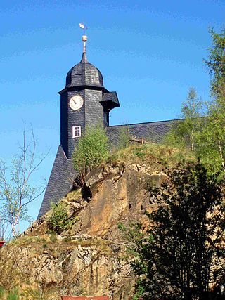
The Ölbergshöhe in the Harz Mountains of central Germany is a mountain spur, 320.6 metres (1,052 ft) above sea level, of the Ramberg ridge near Bad Suderode in the Saxony-Anhalt county of Harz.

The Bergrat Müller Pond, named after a former mining director, Müller, in the Harz mountains of central Germany is a storage pond laid out from 1737 to 1738. It has an area of about 1.3 ha and lies in the forested southern part of the borough of Quedlinburg in the county of Harz in Saxony-Anhalt.
The Scharfenstein is a hill spur, 462.4 m above sea level (NN), of the Eichberg-Süd (486.4 m) in the Harz Mountains of Germany, near the town of Wernigerode in the county of Harz in Saxony-Anhalt.


