Sirarakhong also called as Kampha is a village located west of Ukhrul in Ukhrul district, Manipur state, India. As per 2011 census, the village has a total of 202 households with 1243 persons of which 620 are male while 623 are female. Of the total population, 10.86% are in the age group of 0–6 years. The average sex ratio of the village is 1015 female per 1000 male which is higher than the state's average of 930. The literacy rate of the village is 95.22%.
Shirui, initially called Shiroy/Shiroi, is a village located north of Ukhrul in Ukhrul district, Manipur state, India. The village is 15 kilometers from Ukhrul. National Highway 150 Imphal-Kohima via Jessami passes through the village. The village is divided into two parts, Shirui ato and Shirui aze; however, both the parts are under one chief. Shirui is famous for the rich and flora found on Shirui Kashong or Shirui peak and especially for blooming of the rare Lilium mackliniae during the start of Monsoon. The village is flanked by Ukhrul in the west, Langdang in the south, Mapum in the east, Sihai in the North east and Lunghar in the north. Locally inhabitants speak Shirui dialect which belongs to the Tibeto-Burman language family.
Shingkap is a village located south of Ukhrul in Ukhrul district, Manipur state, India. The village is about 35 kilometers from Ukhrul via National Highway 150 that connects Imphal and Kohima via Ukhrul and Jessami. Shingkap is flanked by Lungpha in the north, Riha in the west, Tangkhul Hundung in the south and Alang in the east. Locally, the inhabitants speak Shingkap tui which belongs to the Tibeto-Burman language family.
Tangkhul Hundung is a village south of Ukhrul in Ukhrul district, Manipur, India. The village is about 65 kilometres (40 mi) from Ukhrul and about 45 kilometres (28 mi) from Imphal and is partially connected by National Highway 150 that connects Imphal and Kohima via Ukhrul and Jessami. Tangkhul Hundung is divided into two major parts, Tangkhul Hundung Khullen and Tangkhul Hundung Khunou. The village is flanked by Thoyee in the west, Shingkap in the north, Itham in the south and Alang in the east. Locally, the inhabitants speak Tangkhul Hundung tui, which belongs to the Tibeto-Burman language family.
Shingcha is a village located southeast of Ukhrul in Ukhrul district, Manipur state, India. The village is about 45 kilometers from Ukhrul and is partially connected by Ukhrul-Kamjong State highway. The village is flanked by Pushing in the north, Maku in the south, the Langkhe in the east and Shangshak in the west.
Kamjong/Chassad is the headquarter of Kamjong district, Manipur state, India. The village is about 120 kilometers from Imphal and is connected by Ukhrul-Kamjong State highway. This District headquarter is flanked by Langli in the north, Bungpa in the south, the Phange in the east and Dangthi in the west.
Hungpung also called as Hundung is a village located south in Ukhrul district, Manipur state, India. The village falls under Ukhrul sub division. HAO (Animism) religion was strictly practiced in the kingdom of "KHAYAIWUNG" i,e Kingdom of Hungpung Haokok.
Pharung also called as Shimtang is a village located west of Ukhrul in Ukhrul district, Manipur state, India. The village falls under Ukhrul sub division. Pharung borders with Hunphun (Ukhrul) village and Hungpung. The village is connected by the old National highway road route. Pharung is flanked by Ukhrul in the east, Seikhor in the west, Tashar in the south and Ngainga in the north. Locally the inhabitants speak Pharung tou which belongs to the Tibeto-Burman language family.
Seikhor is a village located west of Ukhrul in Ukhrul district, Manipur state, India. The village falls under Ukhrul sub division. Seikhor is partially connected by the old Imphal-Ukhrul road and is about 18 kilometers from Ukhrul. Seikhor is flanked by Pharung in the east, Teinem in the west, Tashar in the south and Ngainga in the north. Locally, the inhabitants speak Seikhor dialect that belongs to the Tibeto-Burman language family.
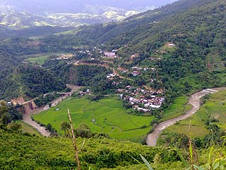
Lamlang also popularly referred as Lamlang Gate is a village located west of Ukhrul in Ukhrul district, Manipur state, India. The village falls under Ukhrul sub division. The old Imphal-Ukhrul road passes through the village and is about 19 kilometers from Ukhrul. Lamlang is flanked by Seikhor in the north, Pharung in the east, Tashar in the south and Sirarakhong in the west. Locally, the inhabitants speak Lamlang dialect that belongs to the Tibeto-Burman language family.
Bungpa is a generic reference to two villages, Bungpa Khullen and Bungpa Khunou located south of Ukhrul in Ukhrul district, Manipur state, India. The village falls under Kamjong sub division. The villages are connected by Ukhrul-Kamjong state highway. Bungpa is flanked by Phungyar in the west, Grihang in the south, Lakhan in the east and Kamjong in the north. Locally, the inhabitants speak Bungpa dialect that belongs to the Tibeto-Burman language family.
Grihang is a village located south of Ukhrul in Ukhrul district, Manipur state, India. The village falls under Kamjong sub division. The village is connected by Ukhrul-Kamjong state highway. Grihang is flanked by Tusom in the west, Ningchou in the south, Molvailup in the east and Bungpa in the north. Locally, the inhabitants speak Grihang dialect that belongs to the Tibeto-Burman language family.
Awang Kasom is a village located north of Ukhrul in Ukhrul district, Manipur state, India. The village falls under Chingai sub division. National Highway 150 that connect Imphal-Kohima via Ukhrul and Jessami passes through the village. Awang Kasom is about 50 kilometers from Ukhrul; and is flanked by kuirei in the south, Peh in the west, Chingai in the north and poi in the east. Locally, the inhabitants speak Awang Kasom dialect that belongs to the Tibeto-Burman language family.
Punge is a small village located west of Kamjong in Kamjong District, Manipur state, India. The village falls under Phungyar sub division. The village is partially connected by Ukhrul-Phungyar state highway and Shangshak-Yairipok district road. Punge is flanked by Mawai in the west, Sorbung in the south, Kangpat in the east and Sorde in the north. Locally, the inhabitants speak Punge dialect that belongs to the Tibeto-Burman language family.
Sorde is a village located south-west of Kamjong in Kamjong District, Manipur state, India. The village falls under Phungyar sub division. The village is partially connected by Ukhrul-Phungyar state highway and Shangshak-Yairipok district road. Sorde is flanked by Khamlang in the west, Punge in the south, Kangpat in the east and Phungyar in the north. Locally, the inhabitants speak Sorde dialect that belongs to the Tibeto-Burman language family.

Khambi is a village located west of Kamjong in Kamjong District, Manipur state, India. The village falls under Phungyar sub division. The village is partially connected by Ukhrul-Phungyar state highway and Shangshak-Yairipok district road. Khambi is flanked by Khamlang in the west, Sorde in the south, Kangpat in the east and Phungyar in the north. Locally, the inhabitants speak Khambi dialect that belongs to the Tibeto-Burman language family.
Ashang Khullen is a Tangkhul village in Ukhrul district, Manipur state, India. The village falls under the Ukhrul-South sub division. The village is connected by National Highway 102 that connects Shangshak and Yairipok. Ashang Khullen is flanked by Chongdan Village in the west, Nambashi in the south, Punge and Sorde in the east and Kangoi in the north. Locally, the inhabitants speak Ashang Khullen dialect that belongs to the Tibeto-Burman language family.
Itham is a Tangkhul village in Kamjong District, Manipur state, India. The village falls under Kasom sub division. The village is connected by National Highway 102A that connects Shangshak-Yairipok. Itham is flanked by Heirok in the west, Leihaoram in the south, Nongdam in the east and Moirangpurel in the north. Locally, the inhabitants speak Itham dialect that belongs to the Tibeto-Burman language family.
Nongdam is a village in Imphal East district, Manipur state, India. The village falls under Sowombung sub division. The village is partially connected by National Highway 202 that connects Jessami and Imphal. Nongdam is flanked by Leishiphung in the west, Itham in the south, Chadong in the east and Riha in the north. (Provide info in detailed manner) (Stop biased proclaims)
Chadong refers to a Tangkhul village in Kamjong district, Manipur state, India. The village falls under Phungyar sub division. The village is partially connected by National Highway 150 that connects Jessami and Imphal. Chadong is flanked by Riha in the North, Nongdam in the South, Yaingangpokpi in the west and Shingkap in the east. Locally, the inhabitants speak Chadong dialect that belongs to the Tibeto-Burman language family.

