Rio Alamo

Last updated
Río Álamo
Country Mexico
State Tamaulipas
Mouth Rio Grande
 - location Ciudad Mier
 - coordinates 26°25′N99°6′W / 26.417°N 99.100°W / 26.417; -99.100 Coordinates: 26°25′N99°6′W / 26.417°N 99.100°W / 26.417; -99.100   [1]
Basin 4,339 km2 (1,675 sq mi) [2]
Discharge for IBWC station 08-4642 at Ciudad Mier
 - average 3.67 m3/s (130 cu ft/s) [2]
 - max 2,470 m3/s (87,227 cu ft/s)
 - min 0 m3/s (0 cu ft/s)

The Río Álamo, is a stream in the state of Tamaulipas, Mexico, and is a tributary of the Rio Grande. It is impounded by Las Blancas Dam, which was completed in 2001 and diverts water to the Marte Gómez Reservoir on the Rio San Juan, another tributary of the Rio Grande. [2]

Tamaulipas State of Mexico

Tamaulipas, officially the Free and Sovereign State of Tamaulipas, is one of the 31 states which, with Mexico City, comprise the 32 Federal Entities of Mexico. It is divided into 43 municipalities and its capital city is Ciudad Victoria.

Mexico country in the southern portion of North America

Mexico, officially the United Mexican States, is a country in the southern portion of North America. It is bordered to the north by the United States; to the south and west by the Pacific Ocean; to the southeast by Guatemala, Belize, and the Caribbean Sea; and to the east by the Gulf of Mexico. Covering almost 2,000,000 square kilometres (770,000 sq mi), the nation is the fifth largest country in the Americas by total area and the 13th largest independent state in the world. With an estimated population of over 120 million people, the country is the eleventh most populous state and the most populous Spanish-speaking state in the world, while being the second most populous nation in Latin America after Brazil. Mexico is a federation comprising 31 states and Mexico City, a special federal entity that is also the capital city and its most populous city. Other metropolises in the state include Guadalajara, Monterrey, Puebla, Toluca, Tijuana and León.

Rio Grande river forming part of the US-Mexico border

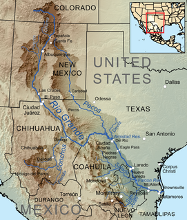
The Rio Grande is one of the principal rivers in the southwest United States and northern Mexico. The Rio Grande begins in south-central Colorado in the United States and flows to the Gulf of Mexico. Along the way, it forms part of the Mexico–United States border. According to the International Boundary and Water Commission, its total length was 1,896 miles (3,051 km) in the late 1980s, though course shifts occasionally result in length changes. Depending on how it is measured, the Rio Grande is either the fourth- or fifth-longest river system in North America.

The Rio Alamo enters the Rio Grande (Rio Bravo del Norte in Mexico) at Rio Grande river kilometer 422 kilometres (262 mi), about 20 kilometres (12 mi) downriver from Falcon Dam. [2]

Falcon Dam

Falcon Dam is an earthen embankment dam on the Rio Grande between Starr County in the U.S. state of Texas and the city of Nueva Ciudad Guerrero in the Mexican state of Tamaulipas. The dam was built for water conservation, irrigation, hydroelectric power generation, flood control, and recreational purposes and as an international border crossing between Zapata and Starr Counties and Tamaulipas. Construction on the dam began in December 1950 and ended in April 1954 but it was dedicated by presidents Adolfo Ruiz Cortines and Dwight D. Eisenhower in October 1953.

See also

Urban water management in Monterrey, Mexico City in Nuevo León, Mexico

Beginning early in the 20th century, Monterrey, Mexico began a successful economic metamorphosis and growth pattern that remains an exception in Mexico. This all began with increased investments in irrigation that fueled a boom in agriculture and ranching for this northern Mexican city. The economic growth has fueled income disparity for the 3.86 million residents who live in the Monterrey Metro area (MMA). In addition, the rapid urbanization has taken a large toll on the water resources. In addressing many of this challenges, the city of Monterrey has become a model for sound and effective Integrated urban water management.

Related Research Articles

Colorado River (Argentina) river in Argentina

The Colorado River is a river in the south of Argentina.

Pecos River river in the United States of America

The Pecos River originates in north-central New Mexico and flows into Texas, emptying into the Rio Grande. Its headwaters are on the eastern slope of the Sangre de Cristo mountain range in Mora County north of Pecos, NM, at an elevation of over 12,000 feet (3,700 m) feet. The river flows for 926 miles (1,490 km) before reaching the Rio Grande near Del Rio. Its drainage basin encompasses about 44,300 square miles (115,000 km2).

Gila River river in the United States of America

The Gila River is a 649-mile (1,044 km) tributary of the Colorado River flowing through New Mexico and Arizona in the United States. The river drains an arid watershed of nearly 60,000 square miles (160,000 km2) that lies mainly within the U.S. but also extends into northern Sonora, Mexico. Indigenous peoples have lived along the river for at least 2,000 years, establishing complex agricultural societies before European exploration of the region began in the 16th century. However, European Americans did not permanently settle the Gila River watershed until the mid-19th century.

Rio Conchos river in Mexico

The Río Conchos is a large river in the Mexican state of Chihuahua. It joins the Río Bravo del Norte at the town of Ojinaga, Chihuahua.

Grande de Santiago River river in Mexico

The Grande de Santiago River is one of the longest rivers in Mexico, measuring up 433 km (269 mi) long. The river begins at Lake Chapala and continues roughly north-west through the Sierra Madre Occidental, receiving the Verde, Juchipila, Bolaños, and other tributaries. At La Yesca, the La Yesca Dam was completed in 2012 and the El Cajón Dam was completed downstream in 2007. Below El Cajón, the Aguamilpa Dam was completed in 1993, creating a reservoir covering a large part of the territory of the municipality of El Nayar in Nayarit. From Aguamilpa, the river descends to the coastal lowlands, passing by Santiago Ixcuintla and empties into the Pacific Ocean, 16 km (10 mi) northwest of San Blas, in Nayarit. The river is viewed by some sources as a continuation of the Lerma River, which flows into Lake Chapala.

Rio Chama

The Rio Chama, a major tributary river of the Rio Grande, is located in the U.S. states of Colorado and New Mexico. The river is about 130 miles (210 km) long altogether. From its source to El Vado Dam its length is about 50 miles (80 km), from El Vado Dam to Abiquiu Dam is about 51 miles (82 km), and from Abiquiu Dam to its confluence with the Rio Grande is about 34 miles (55 km).

San Juan River (Tamaulipas)

The San Juan River is the largest and most important river in the Mexican state of Nuevo León. The river feeds the El Cuchillo Dam, which provides the city of Monterrey with water. The San Juan River basin has a total surface area of 33,538 square kilometres (12,949 sq mi). The San Juan River is a tributary to the Rio Grande — which is the fourth largest river basin in North America. It begins in Coahuila, flows through Nuevo León and into Tamaulipas, where it finally joins the Rio Grande near Camargo, Tamaulipas.

Santa Fe River (New Mexico)

The Santa Fe River is a tributary of the Rio Grande in northern New Mexico. It starts in the Sangre de Cristo mountain range and passes through the state capital, Santa Fe providing approximately 40% of the city's water supply. It is an intermittent stream with two perennial reaches.

Rio Salado (Mexico) river in northern Mexico

The Río Salado, also Río Salado de los Nadadores, or Salado River, is a river in northern Mexico, a tributary of the Rio Grande (Río Bravo). Its basin extends across the northern portion of Coahuila, Nuevo Leon, and Tamaulipas states.

Terlingua Creek is a stream in the U.S. state of Texas. It is a tributary of the Rio Grande.

The Escondido River is a stream in the state of Coahuila, Mexico, and is a tributary of the Rio Grande.

The Río San Rodrigo is a stream in the state of Coahuila, Mexico, and is a tributary of the Rio Grande.

Jemez River river in the United States of America

The Jemez River is a tributary of the Rio Grande in the U.S. state of New Mexico. The river is formed by the confluence of the East Fork Jemez River and San Antonio Creek, which drain a number of tributaries in the area of the Jemez Mountains and Santa Fe National Forest. The Jemez River is about 50 miles (80 km) long, or about 80 miles (130 km) long if its longest headwater tributary, San Antonio Creek, is included. The East Fork Jemez River is about 22 miles (35 km) long. Both San Antonio Creek and the East Fork Jemez River flow through intricate meanders along their courses. The East Fork Jemez is a National Wild and Scenic River.

Rio Pueblo de Taos River in New Mexico, USA

The Rio Pueblo de Taos, also known as Rio Pueblo, is a tributary of the Rio Grande in the U.S. state of New Mexico. From its source in the Sangre de Cristo Mountains it flows about 33 miles (53 km), generally south and west, to join the Rio Grande in the Rio Grande Gorge. On the way the river passes by Taos and through Taos Pueblo.

El Vado Dam

El Vado Dam lies on the Rio Chama in the U.S. state of New Mexico, about 105 miles (169 km) north-northwest of New Mexico's largest city, Albuquerque and about 80 miles (130 km) northwest of the capital city of Santa Fe. The earth-filled structure forms El Vado Lake, a storage reservoir for the Middle Rio Grande Project.

San Juan-Chama Project

The San Juan-Chama Project is a U.S. Bureau of Reclamation interbasin water transfer project located in the states of New Mexico and Colorado in the United States. The project consists of a series of tunnels and diversions that take water from the drainage basin of the San Juan River – a tributary of the Colorado River – to supplement water resources in the Rio Grande watershed. The project furnishes water for irrigation and municipal water supply to cities along the Rio Grande including Albuquerque and Santa Fe.

Albuquerque Basin

The Albuquerque Basin is one of the largest and deepest of the structural basins in the Rio Grande rift. It contains the city of Albuquerque, New Mexico.

References