Ripapa Island

Last updated

Ripapa Island
Native name:
Rīpapa (Māori)
Fort Jervois Ripapa Island.jpg
Fort Jervois
NZ Banks Peninsula relief location map.svg
Red pog.svg
Ripapa Island
Location of Ripapa Island
Geography
Coordinates 43°37′12″S172°45′16″E / 43.6201°S 172.7544°E / -43.6201; 172.7544
Administration
New Zealand
Demographics
Population0
Official nameFort Jervois
Designated22 August 1991
Reference no.5306
1872 map of Ripapa Island Ripapa Island 1872 map.png
1872 map of Ripapa Island

Ripapa Island (Māori : Rīpapa), also known earlier as Ripa Island, [1] located just off the shore of Lyttelton Harbour, has played many roles in the history of New Zealand. A Māori fortified there played a key role in an internal struggle for the South Island Ngāi Tahu tribe in the early 19th century. Between 1873 and 1885, the island hosted a quarantine station, which was also used as a temporary prison for members of the Parihaka Māori settlement in Taranaki. Fort Jervois was built in 1886 as part of system of defences against a feared Russian invasion. The fort was in military use until the end of World War I, and again during World War II. It is the most complete Russian-scare fort still existing in New Zealand.

Contents

19th century Māori history

Ripapa Island was a perfect location for a (a fortification built by the Māori) and chief Taununu of the Ngāi Tahu tribe built one there in the early 19th century. In the 1820s, Taununu faced a fierce fight with another Ngāi Tahu group, in what was to be known as the Kai huanga feud. Kai huanga, meaning "eat relatives", refers to the cannibalistic nature of the feud and that those they fought and ate were close relatives, even getting to a point where cousin would eat cousin. The Ngāi Tahu tribe continued to occupy the island until around 1832. Prior to this, chief Te Whakarukeruke, who had been occupying Ripapa Island, left to help defend Kaiapoi from Te Rauparaha. After Kaiapoi fell, Te Rauparaha overran a number of pā on and around Banks Peninsula, including the pā on Ripapa Island. The island was never again occupied by Māori. [2]

Quarantine station and prison

Between 1873 and 1885, the island was used as a quarantine station for ships arriving from Britain to the nearby port in Lyttelton. [3] In 1880 the quarantine buildings were used as a prison, notably for members of the Parihaka Māori settlement in Taranaki during its passive resistance campaign against the surveying and selling of its land by the government. [4] The quarantine buildings were dismantled and moved to Quail Island in 1885, [5] to be replaced by a coastal defence fort on Ripapa. [6]

Fort Jervois

Derelict Armstrong guns and emplacements Derelict Armstrong guns Ripapa Island.JPG
Derelict Armstrong guns and emplacements
8-inch Armstrong gun mechanism 8lb Armstrong gun, Ripapa Island.JPG
8-inch Armstrong gun mechanism

A walled fort, initially named Fort Ripa, was built on Ripapa in 1886 as part of a nationwide coastal defence system constructed due to the Russian scare, a fear that Russia would invade New Zealand. One of four fortifications set up to protect Lyttelton Harbour, it was renamed Fort Jervois after Lieutenant General Sir William Jervois in 1888. Four disappearing guns were installed by 1889. The fort was occupied by the New Zealand army until the end of World War I, during which it housed some prisoners of war, including Felix von Luckner. [5] [7] It was again garrisoned during World War II. [6]

The fort is currently the home of two extremely rare guns. One is a BL 8-inch gun (one of only 12 left in the world), which is still in working order, though there are no shells left for such a weapon. It also holds a smaller BL 6-inch gun. However, at the first test shot the recoil system failed, with the result that the barrel cracked and most of the rest of the gun was damaged and was returned to England for repairs. A test fire in 1939 cracked the mounting. Though these are the only two guns currently in place at Fort Jervois, there are emplacements for another two guns. These two guns are on the island but have been partially destroyed.[ citation needed ]

The island has been under the control of the Department of Conservation since 1990. Fort Jervois is classed as a Category I historic place by Heritage New Zealand, [5] and has been considered "actively managed" by the Department of Conservation. [6] It is the most complete Russian-scare fort still existing in New Zealand.[ citation needed ]

The June 2011 Christchurch earthquake damaged Fort Jervois and it was closed for some time. Remedial repairs were made, and the island reopened in November 2019, [8] with public ferry services from Lyttelton wharf resuming in 2020. [9]

See also

Related Research Articles

Iwi are the largest social units in New Zealand Māori society. In Māori, iwi roughly means 'people' or 'nation', and is often translated as "tribe," or "a confederation of tribes." The word is both singular and plural in the Māori language, and is typically pluralised as such in English.

<span class="mw-page-title-main">Parihaka</span> Place in Taranaki, New Zealand

Parihaka is a community in the Taranaki region of New Zealand, located between Mount Taranaki and the Tasman Sea. In the 1870s and 1880s the settlement, then reputed to be the largest Māori village in New Zealand, became the centre of a major campaign of non-violent resistance to European occupation of confiscated land in the area. Armed soldiers were sent in and arrested the peaceful resistance leaders and many of the Maori residents, often holding them in jail for months without trials.

<span class="mw-page-title-main">Te Rauparaha</span> Māori chief and war leader of Ngāti Toa (1760s–1849)

Te Rauparaha was a Māori rangatira, warlord, and paramount chief of the Ngāti Toa iwi. One of the most powerful military leaders of the Musket Wars, Te Rauparaha fought a war of conquest that greatly expanded Ngāti Toa southwards, receiving the epithet "the Napoleon of the South". He remains one of the most prominent and celebrated New Zealand historical figures.

<span class="mw-page-title-main">Musket Wars</span> Armed conflicts between Māori tribes in New Zealand before 1845

The Musket Wars were a series of as many as 3,000 battles and raids fought throughout New Zealand among Māori between 1806 and 1845, after Māori first obtained muskets and then engaged in an intertribal arms race in order to gain territory or seek revenge for past defeats. The battles resulted in the deaths of between 20,000 and 40,000 people and the enslavement of tens of thousands of Māori and significantly altered the rohe, or tribal territorial boundaries, before the signing of the Treaty of Waitangi in 1840. The Musket Wars reached their peak in the 1830s, with smaller conflicts between iwi continuing until the mid 1840s; some historians argue the New Zealand Wars were a continuation of the Musket Wars. The increased use of muskets in intertribal warfare led to changes in the design of pā fortifications, which later benefited Māori when engaged in battles with colonial forces during the New Zealand Wars.

<span class="mw-page-title-main">Ngāi Tahu</span> Māori iwi in New Zealand

Ngāi Tahu, or Kāi Tahu, is the principal Māori iwi (tribe) of the South Island. Its takiwā is the largest in New Zealand, and extends from the White Bluffs / Te Parinui o Whiti, Mount Mahanga and Kahurangi Point in the north to Stewart Island / Rakiura in the south. The takiwā comprises 18 rūnanga corresponding to traditional settlements. According to the 2018 census an estimated 74,082 people affiliated with the Kāi Tahu iwi.

<span class="mw-page-title-main">Kaiapoi</span> Town in Canterbury, New Zealand

Kaiapoi is a town in the Waimakariri District of the Canterbury region, in the South Island of New Zealand. The town is located approximately 17 kilometres north of central Christchurch, close to the mouth of the Waimakariri River. It is considered a satellite town of Christchurch and is part of the Christchurch functional urban area.

<span class="mw-page-title-main">Otakou</span> Place in Otago, New Zealand

Otakou is a settlement within the boundaries of the city of Dunedin, New Zealand. It is located 25 kilometres from the city centre at the eastern end of Otago Peninsula, close to the entrance of Otago Harbour. Though a small fishing village, Otakou is important in the history of Otago for several reasons. The settlement is the modern centre and traditional home of the Ōtākou rūnanga (assembly) of Ngāi Tahu. In 1946 Otakou Fisheries was founded in the township; this was later to become a major part of the Otago fishing industry.

<span class="mw-page-title-main">Lake Grassmere</span> Lagoon in Marlborough Region, South Island

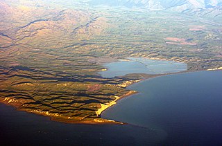
Lake Grassmere / Kapara Te Hau is a New Zealand waituna-type lagoon in the northeastern South Island, close to Cook Strait. The lake is used for the production of salt.

<span class="mw-page-title-main">Lyttelton Harbour</span> Inlet on Banks Peninsula, New Zealand

Lyttelton Harbour / Whakaraupō is a major inlet on the northwest side of Banks Peninsula, on the coast of Canterbury, New Zealand; the other major inlet is Akaroa Harbour, which enters from the southern side of the peninsula. Whakaraupō enters from the northern coast of the peninsula, heading in a predominantly westerly direction for approximately 15 km (9.3 mi) from its mouth to the aptly-named Head of the Bay near Teddington. The harbour sits in an eroded caldera of the ancient Banks Peninsula Volcano, the steep sides of which form the Port Hills on its northern shore.

Tohu Kākahi was a Māori leader, a warrior leader in the anti government Hau Hau Movement 1864-66 and later a prophet at Parihaka, who along with Te Whiti o Rongomai organised passive resistance against the occupation of Taranaki in the 1870s in New Zealand.

<span class="mw-page-title-main">Ōnawe Peninsula</span> New Zealand volcanic plug

The Ōnawe Peninsula is a volcanic plug inside Akaroa Harbour, on Banks Peninsula in Canterbury, New Zealand. It is the site of a former pā. It is part of the Banks Peninsula Volcano.

The history of the Canterbury Region of New Zealand dates back to settlement by the Māori people in about the 10th century.

The Otago region of New Zealand is one of the more isolated places of the inhabited earth. Its high latitude, elevation and distance from larger foreign and domestic population centres have defined Otago at each stage of its history.

The following lists events that happened during 1832 in New Zealand.

The following lists events that happened during 1831 in New Zealand.

<span class="mw-page-title-main">Te Pēhi Kupe</span>

Te Pēhi Kupe was a Māori rangatira and war leader of Ngāti Toa and the uncle of Te Rauparaha. He took a leading part in what became known as the Musket Wars.

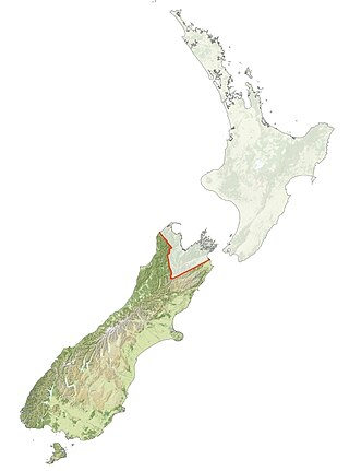
The history of the Nelson Region of New Zealand dates back to settlement by the Māori people in about the 12th century. The Nelson and Marlborough Region were known to the Māori as Te Tau Ihu o Te Waka a Maui which means "The Prow of the Canoe of Maui".

<span class="mw-page-title-main">Tuahiwi</span> Village in Canterbury, New Zealand

Tuahiwi is a small New Zealand settlement located between Woodend and Rangiora. It is 6 kilometres (3.7 mi) north of Kaiapoi.

<span class="mw-page-title-main">Takapūneke</span> Place in Christchurch City, New Zealand

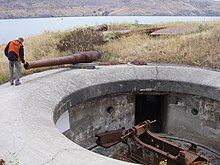
Takapūneke, with the location also known as Red House Bay, is a former kāinga—an unfortified Māori village—adjacent to present-day Akaroa, New Zealand. Takapūneke was a major trading post for the local iwi (tribe), Ngāi Tahu, as there was safe anchorage for European vessels. The site is of significance to Ngāi Tahu as their tribal chief, Tama-i-hara-nui, was captured here by North Island Ngāti Toa chief Te Rauparaha, and then tortured and killed. The village itself was raided and subject of a massacre, with the events subsequently called the Elizabeth affair. There is a direct link from the massacre in 1830 to the signing of the Treaty of Waitangi in 1840, giving the site a status of national significance.

Ross Calman is a New Zealand Māori writer, editor, historian, and translator of the Māori language.
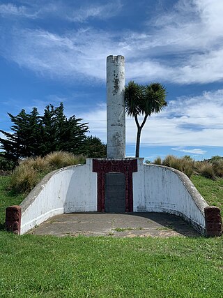
References

  1. "Ripapa Island". New Zealand Gazetteer. Land Information New Zealand. Retrieved 14 December 2021.
  2. "Ripapa – an ideal pa site". Department of Conservation. Retrieved 21 July 2022.
  3. Weekes, John (9 February 2020). "Quarantined: A sordid, sickly, sad underside of New Zealand history". Stuff. Retrieved 16 February 2020.
  4. The Taranaki Report: Kaupapa Tuatahi by the Waitangi Tribunal, chapter 7.
  5. 1 2 3 "Fort Jervois". New Zealand Heritage List/Rārangi Kōrero. Heritage New Zealand . Retrieved 25 April 2011.
  6. 1 2 3 "Ripapa Island Historic Reserve: History and culture". Department of Conservation. Retrieved 21 July 2022.
  7. Munro, Robin (14 April 2012). "War hero or a braggart?". The Press . pp. C10–C11. Retrieved 19 October 2014.
  8. "Historic Ripapa Island open for summer visitors". The Beehive. Retrieved 4 January 2020.
  9. "Ripapa Island". Black Cat Cruises. 17 December 2019. Retrieved 4 January 2020.