
The Northland Region is the northernmost of New Zealand's 16 local government regions. New Zealanders sometimes refer to it as the Winterless North because of its mild climate all throughout the year. The major population centre is the city of Whangārei, and the largest town is Kerikeri. At the 2018 New Zealand census, Northland recorded a population growth spurt of 18.1% since the previous 2013 census, placing it as the fastest growing region in New Zealand, ahead of other strong growth regions such as the Bay of Plenty Region and Waikato.

Kaipara District is a territorial authority district in the Northland Region of New Zealand.

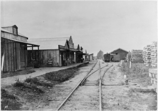
Dargaville is a town located in the North Island of New Zealand. It is situated on the bank of the Northern Wairoa River in the Kaipara District of the Northland region. Dargaville is located 55 kilometres (34 mi) southwest of Whangārei, and 174 kilometres (108 mi) north of Auckland.

Ngāti Whātua is a Māori iwi (tribe) of the lower Northland Peninsula of New Zealand's North Island. It comprises a confederation of four hapū (subtribes) interconnected both by ancestry and by association over time: Te Uri-o-Hau, Te Roroa, Te Taoū, and Ngāti Whātua-o-Ōrākei. The four hapū can act together or separately as independent tribes.

Kaipara Harbour is a large enclosed harbour estuary complex on the north western side of the North Island of New Zealand. The northern part of the harbour is administered by the Kaipara District and the southern part is administered by the Auckland Council. The local Māori tribe is Ngāti Whātua.

Orewa is a settlement in the northern Auckland Region of New Zealand. It is a suburb of the Hibiscus Coast, just north of the base of the Whangaparāoa Peninsula and 40 kilometres (25 mi) north of central Auckland. The Northern Motorway, part of State Highway 1, passes just inland of Orewa and extends through the twin Johnston Hill tunnels to near Puhoi.

Helensville is a town in the North Island of New Zealand. It is sited 40 kilometres (25 mi) northwest of Auckland, close to the southern extremity of the Kaipara Harbour. State Highway 16 passes through the town, connecting it to Waimauku 16 kilometres (10 mi) to the south, and Kaukapakapa about 12 kilometres (7.5 mi) to the north-east. Parakai is two kilometres (1.2 mi) to the north-west. The Kaipara River runs through the town and into the Kaipara Harbour to the north.
The battle of Moremonui was fought between Ngāti Whātua and Ngāpuhi, two Māori iwi (tribes), in northern New Zealand in either 1807 or 1808. The Ngāpuhi force had a few muskets, making this the first occasion Māori used muskets in warfare. The Ngāti Whātua force ambushed the Ngāpuhi, and won the battle, which occurred at Moremonui Gully where it enters Ripiro Beach, 19 kilometres south of Maunganui Bluff on the west coast of Northland. It could reasonably be called the first battle of the Musket Wars among Māori, which took place over the next few decades.

Ahipara is a town and locality in Northland, New Zealand at the southern end of Ninety Mile Beach, with the Tauroa Peninsula to the west and Herekino Forest to the east. Ahipara Bay is to the north west. Kaitaia is 14 km to the north east, and Pukepoto is between the two.
Aranga is a locality in Northland, New Zealand. State Highway 12 passes through it. Ōmāpere is 47 km northwest, and Dargaville is 42 km southeast. The Waipoua Forest is to the north. Maunganui Bluff and the Tasman Sea are to the west, with the small settlement of Aranga Beach lying at the northern end of Ripiro Beach.
Kaihu is a locality and settlement in Northland, New Zealand. The Kaihu River runs through the Kaihu Valley into the Wairoa River near Dargaville, approximately 32 km south east. State Highway 12 runs along the valley and passes through Kaihu settlement. Aranga is about 10 km north west. The Kaihu Forest is to the east and the Marlborough Forest is to the north.

The Pouto Peninsula is a landform on the northern Kaipara Harbour in Northland, New Zealand. The Peninsula runs in the north west to south east direction and is approximately 55 km long. The width varies from about 5.4 km to about 14 km, with the widest part of the peninsula near its southern end. The Tasman Sea is to the west, and the Kaipara Harbour is to the south. The Wairoa River and Kaipara Harbour are to the east. Dargaville and State Highway 12 lie directly to the north east of the peninsula. The mouth of the Kaipara Harbour separates the peninsula from the smaller Te Korowai-o-Te-Tonga Peninsula to the south.
Te Kōpuru is the largest community on the Pouto Peninsula in Northland, New Zealand. The Wairoa River separates the peninsula at this point from the main North Auckland Peninsula to the east. Dargaville is 14 km (8.7 mi) to the north.

Te Kawerau ā Maki, Te Kawerau a Maki, or Te Kawerau-a-Maki is a Māori iwi (tribe) of the Auckland Region of New Zealand. Predominantly based in West Auckland, it had 251 registered adult members as of June 2017. The iwi holds land for a new marae and papakāinga at Te Henga that was returned in 2018; and land for a secondary marae at Te Onekiritea that was returned in 2015. it has no wharenui yet.

Te Roroa is a Māori iwi from the region between the Kaipara Harbour and the Hokianga Harbour in Northland, New Zealand. They are part of the Ngāti Whātua confederation of tribes.

Te Uri-o-Hau is a Māori iwi (tribe) based around New Zealand's Kaipara Harbour. It is both an independent iwi and a hapū (sub-tribe) of the larger Ngāti Whātua iwi, alongside Ngāti Whātua-o-Ōrākei, Te Roroa and Te Taoū. Its rohe includes Dargaville, Maungaturoto, Mangawhai, Kaiwaka and Wellsford.

Schnapper Rock is a western suburb on the North Shore of Auckland, New Zealand. The suburb is currently under local governance of Auckland Council. The area was known for a gum digging hut used by early European settlers in the mid-19th century. North Shore Memorial Park was opened area in 1974, and the area developed into suburban housing in the early 2000s.

Baylys Beach is a beach and settlement on the west coast of Northland, New Zealand. The beach is on the northern side of the settlement, with Ripiro Beach on the southern side. Dargaville is 13 km (8.1 mi) to the east.
The Kaihu Forest is a forested area located in the Northland region of New Zealand, near the Kaihu River and the settlement of Kaihu. The forest is part of the broader ecological landscape of the region, which historically included vast stands of native Kauri trees, one of New Zealand’s most iconic tree species.

Glinks Gully is a small settlement located on the west coast of Northland, New Zealand, approximately 16 kilometres (9.9 mi) south of Dargaville. The settlement consists of around 70 houses.

