
New Swabia is a cartographic name sometimes given to an area of Antarctica between 20°E and 10°W in Queen Maud Land, which is claimed as a Norwegian dependent territory under the Antarctic Treaty System. New Swabia was explored by Germany in early 1939 and named after that expedition's ship, Schwabenland, itself named after the German region of Swabia.
The Kraul Mountains are a chain of mountains and nunataks that trend northeastward from Veststraumen Glacier for approximately 70 nautical miles (130 km) in western Queen Maud Land, Antarctica. They were discovered by the Third German Antarctic Expedition (1938–1939), led by Captain Alfred Ritscher, and named for Captain Otto Kraul, ice pilot of the expedition.
The Payer Mountains is a group of scattered mountains extending north-south for about 37 km (23 mi), standing 15 km (9 mi) east of the Weyprecht Mountains and forming the eastern half of the Hoel Mountains in central Queen Maud Land. They were discovered by the Third German Antarctic Expedition (1938–1939), led by Capt. Alfred Ritscher, and named for Julius Payer, Austrian polar explorer, who in company with Karl Weyprecht discovered Franz Josef Land in 1873.
Penck Trough is a broad ice-filled valley trending southwest to northeast, for about 100 km (62 mi) between Borg Massif and the northeast part of Kirwan Escarpment, in Queen Maud Land. It was discovered by the Third German Antarctic Expedition (1938–1939), led by Capt. Alfred Ritscher, and named for German geographer Albrecht Penck. Maps of the German Antarctic Expedition incorrectly represent this feature with a north-south axis, but it was accurately mapped by the Norwegian-British-Swedish Antarctic Expedition (NBSAE) (1949–1952), led by John Schjelderup Giæver.
Wright Lower Glacier is a stagnant glacier occupying the mouth of Wright Valley and coalescing at its east side with Wilson Piedmont Glacier, in Victoria Land. Formerly called Wright Glacier, but that name was amended by the Victoria University of Wellington Antarctic Expedition (VUWAE) (1958–59) to distinguish this glacier from Wright Upper Glacier at the head of Wright Valley. Originally named by the British Antarctic Expedition (1910–13) for Charles Wright, physicist with the expedition.
The Mühlig-Hofmann Mountains is a major group of associated mountain features extending east to west for 100 km (62 mi) between the Gjelsvik Mountains and the Orvin Mountains in Queen Maud Land, East Antarctica. With its summit at 3,148 metres (10,328 ft), the massive Jøkulkyrkja Mountain forms the highest point in the Mühlig-Hofmann Mountains.
Alfred Ritscher was a German polar explorer. A Kapitän zur See in the Kriegsmarine, he led the third German Antarctic Expedition in 1938-39, which mapped the New Swabia area of Queen Maud Land. Ritscher Peak and Ritscher Upland there are named for him.

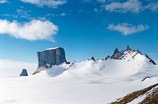
Ritscher Peak is a 2,790-metre (9,150 ft) peak located 11 kilometres (7 mi) west-southwest of Mount Mentzel in the Gruber Mountains of Queen Maud Land, Antarctica. This peak was discovered and mapped by the Third German Antarctic Expedition of 1938–39 and was named for Capt. Alfred Ritscher, leader of the expedition.
Raudberg in the Norwegian language means Red Mountain. Three terrain features in East Antarctica bear the name Raudberg:
- Raudberg Pass
- Raudberg Valley
- Raudberget
Storkvarvet Mountain is a mountain that is round in plan and has several radial spurs, standing N of Habermehl Peak at the NE end of the Muhlig-Hofmann Mountains, Queen Maud Land.
Mount Neustruyev is a peak in East Antarctica, 2,900 m, standing 5 mi NNE of Gneiskopf Peak in Südliche Petermann Range, Wohlthat Mountains, Queen Maud Land.

Bartók Glacier is a glacier, 7 nautical miles (13 km) long and 3 nautical miles (6 km) wide, flowing southwest from the southern end of the Elgar Uplands in the northern part of Alexander Island. It was first photographed from the air and roughly mapped by the British Graham Land Expedition in 1937, and more accurately mapped from air photos taken by the Ronne Antarctic Research Expedition, 1947–48, by D. Searle of the Falkland Islands Dependencies Survey in 1960. It was named by the UK Antarctic Place-Names Committee after the Hungarian composer Béla Bartók.
The Gruber Mountains are a small group of mountains consisting of a main massif and several rocky outliers, forming the northeast portion of the Wohlthat Mountains in Queen Maud Land, Antarctica. They were discovered and plotted from air photos by the Third German Antarctic Expedition (GerAE), 1938–39, under Alfred Ritscher. The mountains were remapped by the Sixth Norwegian Antarctic Expedition, 1956–60, who named them for Otto von Gruber, the German cartographer who compiled maps of this area from air photos taken by the GerAE. This feature is not to be confused with "Gruber-Berge," an unidentified toponym applied by the GerAE in northern the Mühlig-Hofmann Mountains.
Chavez Glacier is a glacier about 10 nmi long flowing south from Canisteo Peninsula into Cranton Bay. It was named by the Advisory Committee on Antarctic Names after Pat Chavez of the United States Geological Survey (USGS), Flagstaff, Arizona, co-leader of the USGS team that compiled the 1:5,000,000-scale Advanced Very High Resolution Radiometer maps of Antarctica in the 1990s.
Neumayer Cliffs is a series of abrupt rock cliffs forming the northeast end of Kirwan Escarpment in Queen Maud Land. Discovered by the German Antarctic Expedition under Alfred Ritscher, 1938–39, and named for German geophysicist Georg von Neumayer. Surveyed by the Norwegian-British-Swedish Antarctic Expedition (NBSAE), 1949-52.
The Gburek Peaks are a group of rocky elevations including Straumsvola Mountain and Jutulrora Mountain, forming the western end of the Sverdrup Mountains in Queen Maud Land, Antarctica. They were discovered by the Third German Antarctic Expedition under Alfred Ritscher, 1938–39, and named for Leo Gburek, geophysicist on the expedition. The name Gburek is here restricted to the westernmost peaks of those so named on maps of the German Expedition, these being clearly recognizable on detailed maps by the Norwegian–British–Swedish Antarctic Expedition, 1949–52, and subsequent Norwegian expeditions.
Hariot Glacier is a glacier flowing northwest along the south side of Morgan Upland before turning west into the northern portion of the Wordie Ice Shelf, along the west coast of the Antarctic Peninsula. It was roughly surveyed by the British Graham Land Expedition, 1936–37, and the upper reaches were photographed from the air by the Ronne Antarctic Research Expedition, 1947. The glacier was surveyed from the ground by members of the Falkland Islands Dependencies Survey who travelled along it in December 1958, and it was named by the UK Antarctic Place-Names Committee after Thomas Hariot, an English mathematician who pioneered new methods of navigation under the patronage of Sir Walter Raleigh.
The Herrmann Mountains are a group of rocky elevations including the Hamrane Heights and the Roots Heights, rising between Reece Valley and Kvitsvodene Valley in the Sverdrup Mountains of Queen Maud Land, Antarctica. They were discovered by the Third German Antarctic Expedition under Alfred Ritscher, 1938–39, and named for Ernst Herrmann, the geographer of the expedition. They were surveyed by the Norwegian–British–Swedish Antarctic Expedition, 1949–52.
Mount Schicht is a prominent mountain with several summits, rising 4 nautical miles (7 km) west-southwest of Ritscher Peak in the Gruber Mountains of Queen Maud Land. The feature was discovered by the German Antarctic Expedition under Ritscher, 1938–39, and named Schichtberge because of its appearance.


