
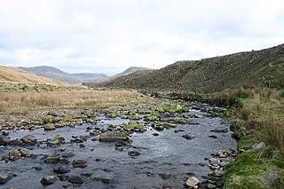
The Duddon Valley is a valley in the southern Lake District National Park in Cumbria, England. The River Duddon flows through the valley, rising in the mountains between Eskdale and Langdale, before flowing into the Irish Sea near Broughton in Furness. In its lower reaches it is bounded by the Furness Fells and Harter Fell.

The Brathay is a river of north-west England. Its name comes from Old Norse and means broad river. It rises at a point 1289 feet above sea level near the Three Shire Stone at the highest point of Wrynose Pass in the Lake District. Its catchment area includes the northern flanks of Wetherlam, Great Carrs and others of the Furness Fells, as well as a substantial area of the Langdale Fells.

The Rothay is a spate river of the Lake District in north-west England. Its name comes from Old Norse and translates literally as the red one. This has come to mean trout river. It rises close to Rough Crag above Dunmail Raise at a point about 1542 feet above sea level. Its catchment area covers Grasmere Common including Easedale Tarn, the southern flanks of Fairfield, and several of the fells to the east of Dunmail Raise, including Great Rigg, Rydal Fell, Scandale Fell and Heron Pike.
The Vale of Eden is formed by the course of the River Eden, one of the major rivers of Northwest England. It is however of much greater extent than the actual valley of the river, lying between the Cumbrian Mountains, and the northern part of the Pennine Range. It lies entirely within the county of Cumbria. The river has its source in the peat bogs below Hugh Seat, in the dale of Mallerstang. At first it determinedly sets off South before turning back North for the rest of its course – except just before its outlet into the sea which it enters from the East.

Cunsey Beck is one of several rivers and streams that replenish the lake of Windermere in the English Lake District. Being just over two miles (3.2 km) in length and generally slow flowing, the stream descends some 87 feet from the southern end of Esthwaite Water, which it drains, to the western banks of Windermere near an island called Ling Holm.

England comprises most of the central and southern two-thirds of the island of Great Britain, in addition to a number of small islands of which the largest is the Isle of Wight. England is bordered to the north by Scotland and to the west by Wales. It is closer to continental Europe than any other part of mainland Britain, divided from France only by a 33 km (21 mi) sea gap, the English Channel. The 50 km (31 mi) Channel Tunnel, near Folkestone, directly links England to mainland Europe. The English/French border is halfway along the tunnel.

The River Irt is a river in the county of Cumbria in northern England. It flows for 14 miles (22 km) from the south-western end of Wast Water, the deepest lake in England, leaving the lake at the foot of Whin Rigg, the southern peak of the famous Wastwater Screes. The name of the river is believed to derive either from the Old English gyr which means "mud", or from the Brittonic words *ar, "flowing", or *īr, "fresh, clean, pure", suffixed with -ed, a nominal suffix meaning "having the quality of...".
The River Bleng is a tributary of the River Irt in the county of Cumbria in northern England.

The River Mite is a river in the county of Cumbria in northern England.
St. John's Beck is a river in the Lake District of Cumbria, England.

The River Eea is a small river in the Lake District, Cumbria, England running through the Furness region, which until 1974 was part of Lancashire. It is a relatively short system that arises from numerous small becks and streams throughout the Cartmel Valley. Its course is approximately 10 km long and its mouth is on Sand Gate marshes near Flookburgh, between Barrow and Kendal. It principally flows in a south-westerly direction.

Pow Beck is a stream in Cumbria, rising near Mirehouse and flowing in a southwesterly direction to the village of St Bees where it flows into the Irish Sea. Despite rising only 0.62 miles (1 km) south of Whitehaven Harbour, the stream flows south for 2.8 miles (4.5 km) to the coast at St Bees. The present course was much altered by the Furness Railway in 1849 to improve the drainage of the valley. This included movement of a weir feeding Seamill, an undershot water mill.

The River Ehen is a river in Cumbria, England.

Newlands Beck is a minor river of Cumbria in England.
Chapel Beck is a minor river in the county of Cumbria in England.

The Wasdale Horseshoe is a group of hills on the eastern fringe of the English Lake District, to the west of the A6, south of Shap, Cumbria. They surround the valley of Wasdale Beck, a tributary of Birk Beck and ultimately of the River Lune. The horseshoe is the subject of a chapter of Wainwright's book The Outlying Fells of Lakeland. This Wasdale should not be confused with the better known Wasdale, containing Wast Water, on the west of the Lake District.

The Naddle Horseshoe is a group of summits in the English Lake District, south of Mardale valley, Cumbria. It is the subject of a chapter of Wainwright's book The Outlying Fells of Lakeland.
The Crookdale Horseshoe is a group of hills on the eastern edge of the English Lake District, in Cumbria, west of the A6 road. They are the subject of a chapter of Wainwright's book The Outlying Fells of Lakeland. Wainwright describes an anticlockwise walk starting along the valley of Crookdale Beck to reach Lord's Seat at 1,719 feet (524 m), and returning over Robin Hood at 1,613 feet (492 m) and High House Bank at 1,627 feet (496 m). As he points out, the ridge forming the northern part of the "horseshoe" is described in his Wasdale Horseshoe chapter.
Rigg Beck is a minor river of Cumbria in England.

Trout Beck is a 7.6 miles (12.3 km) long stream or beck in the English Lake District, Cumbria. It rises on the northwestern slopes of Great Dodd, with tributaries including Groove Beck and Thornsgill Beck, and flows east then north to the hamlet of Troutbeck. It then flows west, parallel to and south of the A66 road, going just south of Hutton Moor End then under the old Hutton Moor Road at Wolt Bridge where it joins the River Glenderamackin.
