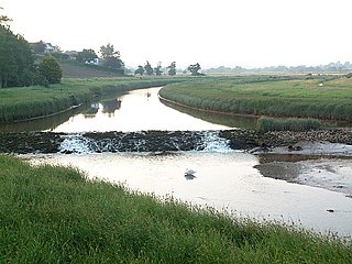
The Tamar is a river in south west England, that forms most of the border between Devon and Cornwall. A part of the Tamar valley is a World Heritage Site due to its historic mining activities.

The Tavy is a river on Dartmoor, Devon, England. The name derives from the Brythonic root "Tam", once thought to mean 'dark' but now generally understood to mean 'to flow'. It has given its name to the town of Tavistock and the villages of Mary Tavy and Peter Tavy. It is a tributary of the River Tamar and has as its own tributaries:

The Walkham is a river whose source is on Dartmoor, Devon, England. It rises in the wide gap between Roos Tor and Great Mis Tor and flows almost due south for approximately 3 miles (4.8 km) leaving the tors and thus National Park behind then south-west for 1 mile (1.6 km) past Woodtown. The river then reaches a village, Horrabridge, with a small compact network of streets mainly on the south or left bank. It receives most of its tributaries which are unnamed headwaters along its south-flowing inception, draining the near side of two series of six tors (peaks) to the west ending in Pew Tor at 320 metres and likewise to the east ending in Leeden Tor at 389 metres. In absolute distance, 2 miles (3.2 km) west of the village and the same south of the small well-preserved town of Tavistock by a footbridge on the West Devon Way the Walkham joins the Tavy which discharges into the Tamar Estuary north of the Plymouth conurbation after a fast descent around wide hillsides, a few miles south.

The River Lynher flows through east Cornwall, England, and enters the River Tamar at the Hamoaze, which in turn flows into Plymouth Sound.

Cookbury is a village and civil parish in the local government district of Torridge, Devon, England. The parish, which lies about five miles east of the town of Holsworthy, is surrounded clockwise from the north by the parishes of Thornbury, Bradford, Ashwater, Hollacombe, and Holsworthy Hamlets. In 2001 its population was 158, little changed from the 146 residents it had in 1901.

The Lyd is a river rising at Lyd Head in the Dartmoor national park in Devon in South West England and flowing into the River Tamar beyond Lifton. It runs through Lydford Gorge, the deepest gorge in South West England.

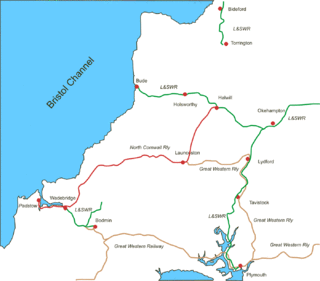
The North Cornwall Railway was a railway line running from Halwill in Devon to Padstow in Cornwall via Launceston, Camelford and Wadebridge, a distance of 49 miles 67 chains. Opened in the last decade of the nineteenth century, it was part of a drive by the London and South Western Railway (LSWR) to develop holiday traffic to Cornwall. The LSWR had opened a line connecting Exeter with Holsworthy in 1879, and by encouraging the North Cornwall Railway it planned to create railway access to previously inaccessible parts of the northern coastal area.

The River Clyst is a river of Devon, England. The name derives from Old English, and translates as Clean-stream. The river lends its name to several settlements on its route, Clyst Honiton, Clyst St Lawrence, Clyst St George, and Broadclyst. The William part of Clyst William derives from the Old English of aewelm, which means river source.
The Okehampton–Bude line was a railway line built to serve Holsworthy in Devon, and Bude on the Cornish coast near the Devon border in England. The line branched from the main line at Meldon Junction to the west of Okehampton on the northern edge of Dartmoor. The line opened in 1879 to Holsworthy and in 1898 to Bude. It is now closed.

Halwill Junction Railway Station was a railway station in Halwill Junction, near the villages of Halwill and Beaworthy in Devon, England. It opened in 1879 and formed an important junction between the now-closed Bude Branch and North Cornwall line. It closed in 1966 along with the lines which it served, a casualty of the Beeching Report.

Ashwater railway station was a railway station that served the hamlets of Ashwater and Ashmill in Devon, England. It was located on the North Cornwall Railway 5 miles (8.0 km) southwest of Halwill, close to the River Carey and approximately 0.5 miles (0.80 km) away from Ashwater.

North Tamerton is a village and civil parish in east Cornwall, England, UK. The village is situated approximately eight miles (13 km) southeast of Bude and eight miles (13 km) north of Launceston.

The A374 is a main road in the United Kingdom, one of six A-roads making the border crossing between Devon and Cornwall. It is the most southerly of the A37x group of roads, starting and ending its journey with the A38 trunk road, from the outskirts of Plymouth in Devon to the Trerulefoot roundabout in Cornwall.

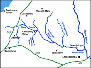
The River Ottery is a small river in northeast Cornwall, United Kingdom. The river is about twenty miles (32 km) long from its source southeast of Otterham to its confluence with the River Tamar at Nether Bridge, two miles (3.2 km) northeast of Launceston.
Tower Hill railway station was a railway station that served a rural district being named after a local farm, near the River Carey, Devon, England. It was located on the North Cornwall Railway 5 miles (8.0 km) southwest of Halwill

Upper Tamar lake is a reservoir on the border of Cornwall and Devon in south-west England. It is owned by South West Water and managed by the South West Lakes Trust. The reservoir serves the water supply in the Bude area of Cornwall and surrounding districts, including Clovelly, Bradworthy and Warbstow.

Clawton is a village and civil parish in the far west of Devon, England. It forms part of the local government district of Torridge. The village lies about three miles south of the town of Holsworthy on the A388 road. The parish is surrounded clockwise from the north-west by the parishes of Pyworthy, Holsworthy Hamlets, Ashwater, and Tetcott. Its western border follows the River Tamar which forms the county boundary with Cornwall. In 2001 its population was 326, slightly down from 389 in 1901.

Luffincott is a civil parish in the far west of Devon, England. It forms part of the local government district of Torridge and lies about six miles south of the town of Holsworthy. The parish is surrounded clockwise from the north by the parishes of Tetcott, Ashwater, St Giles on the Heath and Northcott. Its western border follows the River Tamar which forms the county boundary with Cornwall.

Pancrasweek is a civil parish and hamlet in the far west of Devon, England forming part of the local government district of Torridge and lying about three miles north west of the town of Holsworthy.

The River Kensey is a river in east Cornwall, England, UK which is a tributary of the River Tamar.


