
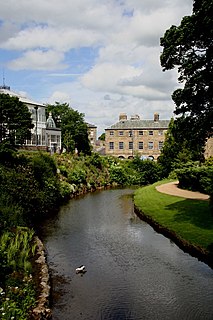
Monmouth is a town and community in Wales. It is situated where the River Monnow joins the River Wye, 2 miles (3.2 km) from the Wales–England border. Monmouth is 30 miles (48 km) northeast of Cardiff, and 113 miles (182 km) west of London. It is within the Monmouthshire local authority, and the parliamentary constituency of Monmouth. The population in the 2011 census was 10,508, rising from 8,877 in 2001. Monmouth is the historic county town of Monmouthshire although Abergavenny is now the county town.
The River Stour is a river in East Anglia, England. It is 47 miles (76 km) long and forms most of the county boundary between Suffolk to the north, and Essex to the south. It rises in eastern Cambridgeshire, passes to the east of Haverhill, through Cavendish, Bures, Sudbury, Nayland, Stratford St Mary, Dedham and flows through the Dedham Vale Area of Outstanding Natural Beauty. It becomes tidal just before Manningtree in Essex and joins the North Sea at Harwich.

The River Wye is the fourth-longest river in the UK, stretching some 250 kilometres from its source on Plynlimon in mid Wales to the Severn estuary. For much of its length the river forms part of the border between England and Wales. The Wye Valley is designated an Area of Outstanding Natural Beauty. The Wye is important for nature conservation and recreation, but is severely affected by pollution.

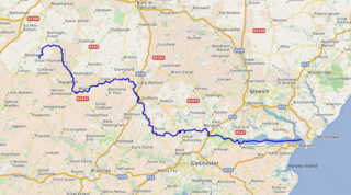
The River Monnow marks the England–Wales border for much of its 42 miles (68 km) length. After flowing through southwest Herefordshire, England, and eastern Monmouthshire, Wales, its confluence with the River Wye is approximately 1⁄3 mile (0.54 km) south of Monmouth.
The River Wye is a limestone river in the Peak District of Derbyshire, England. It is 22 miles in length, and is one of the major tributaries of the River Derwent, which flows into the River Trent, and ultimately into the Humber and the North Sea.

Monmouthshire is a county in the south-east of Wales. The name derives from the historic county of the same name; the modern county covers the eastern three-fifths of the historic county. The largest town is Abergavenny, with other towns and large villages being: Caldicot, Chepstow, Monmouth, Magor and Usk. It borders Torfaen, Newport and Blaenau Gwent to the west; Herefordshire and Gloucestershire to the east; and Powys to the north.

The Kern River, previously Rio de San Felipe, later La Porciuncula, is a Wild and Scenic river in the U.S. state of California, approximately 165 miles (270 km) long. It drains an area of the southern Sierra Nevada mountains northeast of Bakersfield. Fed by snowmelt near Mount Whitney, the river passes through scenic canyons in the mountains and is a popular destination for whitewater rafting and kayaking. It is the southernmost major river system in the Sierra Nevada, and is the only major river in the Sierra that drains in a southerly direction.

The Salinas River is the longest river of the Central Coast region of California, running 175 miles (282 km) and draining 4,160 square miles (10,800 km2). It flows north-northwest and drains the Salinas Valley that slices through the central California Coast Ranges south of Monterey Bay. The river begins in southern San Luis Obispo County, originating in the Los Machos Hills of the Los Padres National Forest. From there, the river flows north into Monterey County, eventually making its way to connect with the Monterey Bay, part of the Pacific Ocean, approximately 5 miles (8.0 km) south of Moss Landing. The river is a wildlife corridor, and provides the principal source of water from its reservoirs and tributaries for the farms and vineyards of the valley.

The River Fal flows through Cornwall, England, rising at Pentevale on Goss Moor and reaching the English Channel at Falmouth. On or near the banks of the Fal are the castles of Pendennis and St Mawes as well as Trelissick Garden. The River Fal separates the Roseland peninsula from the rest of Cornwall. Like most of its kind on the south coast of Cornwall and Devon, the Fal estuary is a classic ria, or drowned river valley. The Fal estuary from Tregony to the Truro River was originally called Hafaraell.

The River Pang is a small chalk stream river in the west of the English county of Berkshire, and a tributary of the River Thames. It runs for approximately 23 kilometres (14 mi) from its source near the village of Compton to its confluence with the Thames in the village of Pangbourne.

The Warrego River is an intermittent river that is part of the Darling catchment within the Murray–Darling basin, which is located in South West Queensland and in the Orana region of New South Wales, Australia. The Warrego River is the northernmost tributary of the Darling River.

The River Chess is a chalk stream that rises near Chesham in the Chiltern Hills, and flows for 11 miles (18 km) through Buckinghamshire and Hertfordshire to its confluence with the River Colne in Rickmansworth. The Chess, along with the Colne and Gade, gives rise to the name of the district of Three Rivers.

The River Llynfi, Welsh: Afon Llynfi, is one of three main tributaries of the River Ogmore.
Abbey Dore is a village and civil parish in Herefordshire, England, known for Dore Abbey, a 12th-century Cistercian abbey, which was expanded in the 13th century.

The River Rom, also known as the River Beam below its confluence with the Ravensbourne, is a tributary of the River Thames in England that flows through east London suburbs surrounding the metropolitan centre of Romford, forming the boundary between the London boroughs of Barking and Dagenham and Havering. The Rom is culverted for a brief midsection as it passes through the centre of Romford.
The Golden Valley is the name given to the valley of the River Dore in western Herefordshire, England. The valley is a picturesque area of gently rolling countryside. It lies in the lee of the Black Mountains, Wales.

Manas National Park is a national park, Project Tiger reserve, biosphere reserve and an elephant reserve in Assam, India. Located in the Himalayan foothills, it is contiguous with Royal Manas National Park in Bhutan. The park is known for its rare and endangered endemic wildlife such as the Assam roofed turtle, hispid hare, golden langur and pygmy hog. Manas is famous for its population of the wild water buffalo.

The River Honddu is a river in the Black Mountains within the Brecon Beacons National Park, southeast Wales. Early recorded versions of the name are of the form Hothenei and hodni which are believed to contain the adjective 'hawdd' meaning for example, pleasant or easy. Later forms such as Honddye have undergone metathesis whereby -ddn- became -ndd-.
The River Tale is a small river that drains the southern slopes of the Blackdown Hills, in Devon, England. It is a tributary of the River Otter and 8.8 miles (14.2 km) in length. Its name is derived from getæl meaning "quick, active or swift"; however, the river is noted as being "sluggish". One theory is that its name was transferred from Tala Water, a tributary of the nearby River Tamar. The river is the site of ongoing efforts to reintroduce the water vole, which is thought to be extinct in Devon.

Llancillo is a civil parish in south-west Herefordshire, England, and is approximately 13 miles (20 km) south-west from the city and county town of Hereford. The parish borders Wales at the south in which is the nearest town, Abergavenny, 7 miles (11 km) to the south-southwest. In the parish is the isolated Grade II* listed 11th-century Church of St Peter.
