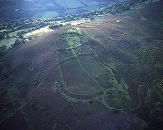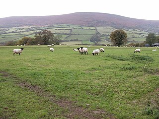
Skirrid Fawr, often referred to as just the Skirrid, is an easterly outlier of the Black Mountains in Wales. It forms the easternmost part of the Brecon Beacons National Park. The smaller hill of Ysgyryd Fach or "Little Skirrid" lies about 2+1⁄2 miles south.

The River Monnow marks the England–Wales border for much of its 42 miles (68 km) length. After flowing through southwest Herefordshire, England, and eastern Monmouthshire, Wales, its confluence with the River Wye is approximately 1⁄3 mile (0.54 km) south of Monmouth.

The Black Mountains are a group of hills spread across parts of Powys and Monmouthshire in southeast Wales, and extending across the England–Wales border into Herefordshire. They are the easternmost of the four ranges of hills that comprise the Brecon Beacons national park, and are frequently confused with the westernmost, which is known as the Black Mountain. The Black Mountains may be roughly defined as those hills contained within a triangle defined by the towns of Abergavenny in the southeast, Hay-on-Wye in the north and the village of Llangors in the west. Other gateway towns to the Black Mountains include Talgarth and Crickhowell. The range of hills is well known to walkers and ramblers for the ease of access and views from the many ridge trails, such as that on the Black Hill in Herefordshire, at the eastern edge of the massif. The range includes the highest public road in Wales at Gospel Pass, and the highest point in southern England at Black Mountain.

Llanthony Priory is a partly ruined former Augustinian priory in the secluded Vale of Ewyas, a steep-sided once-glaciated valley within the Black Mountains area of the Brecon Beacons National Park in Monmouthshire, south east Wales. It lies seven miles north of Abergavenny on an old road to Hay-on-Wye at Llanthony. The priory ruins lie to the west of the prominent Hatterrall Ridge, a limb of the Black mountains. The main ruins are under the care of Cadw and entrance is free.

The geology of Wales is complex and varied; its study has been of considerable historical significance in the development of geology as a science. All geological periods from the Cryogenian to the Jurassic are represented at outcrop, whilst younger sedimentary rocks occur beneath the seas immediately off the Welsh coast. The effects of two mountain-building episodes have left their mark in the faulting and folding of much of the Palaeozoic rock sequence. Superficial deposits and landforms created during the present Quaternary period by water and ice are also plentiful and contribute to a remarkably diverse landscape of mountains, hills and coastal plains.

The Vale of Ewyas is the steep-sided and secluded valley of the River Honddu, in the Black Mountains of Wales and within the Brecon Beacons National Park. As well as its outstanding beauty, it is known for the ruins of Llanthony Priory, and for several noteworthy churches such as those at Capel-y-ffin and Cwmyoy. It is sometimes referred to as the "Llanthony Valley" as Llanthony is the village situated at the valley centre.

Llanvihangel Crucorney is a small village in the community (parish) of Crucorney, Monmouthshire, Wales. It is located 5 miles (8.0 km) north of Abergavenny and 18 miles (29 km) southwest of Hereford, England on the A465 road.

Llanthony is a village in the community of Crucorney on the northern edge of Monmouthshire, South East Wales, United Kingdom.

The Beacons Way is a waymarked long distance footpath in the Brecon Beacons National Park, Wales. It is a linear route which runs for 99 miles (159 km) east to west through the National Park, and passes many of the most important landmarks and mountain peaks in the mountain range. It also includes a few of the towns in the park as well as popular attractions such as Carreg Cennen Castle near Llandeilo at the western end of the path.

The River Gavenny or sometimes the Gavenny River is a short river in Monmouthshire in south Wales. It rises 1 mile (1.6 km) southwest of the village of Llanvihangel Crucorney from springs near Penyclawdd Court, supplemented by springs in Blaen-Gavenny Wood and tributary streams there and within the Woodland Trust-owned Great Triley Wood. It flows south for about 4 miles (6.4 km) to its confluence with the River Usk towards the eastern end of Castle Meadows at Abergavenny. The town derives its English-language name from the Gavenny's confluence with the River Usk. Of the buildings on the banks of the river, the Gothic Decorated style church of St Teilo at Llantilio Pertholey is especially notable. Parts of the church date from the thirteenth century with multiple additions since. Blaengavenny Farm, the name of which signifies the 'head of the Gavenny', is a sixteenth-century farmhouse near the river's source.

The Grwyne Fawr is a river in the Brecon Beacons National Park in south Wales. A section of it forms the administrative border between Powys and Monmouthshire and also of the historic counties of Brecon and Monmouth. The river and its major tributary the Grwyne Fechan flow into the River Usk at Glangrwyney.

Bryn Arw is a hill in the Black Mountains of the Brecon Beacons National Park in Monmouthshire, south Wales. It lies 4 km north of the town of Abergavenny and 1.5 miles west of the village of Llanvihangel Crucorney. Its summit at 384m above sea level is the more northerly of two tops which lie on the crest of a slightly arcuate north-south ridge which drops away to the south at first gently and then sharply. The hill is isolated from the main mass of the range by the valleys of Cwm Coed-y-cerig to the north and by Cwm Brynarw to the west. It is a Marilyn.

Gaer is the name of a hill in the Black Mountains of the Brecon Beacons National Park in Monmouthshire, south Wales. It lies at the southern end of the long ridge between the valley of the Grwyne Fawr and the Vale of Ewyas, one mile north of Bryn Arw and three miles northeast of Sugarloaf. Its summit, at 427m above sea level, sits within an Iron Age hillfort known as Twyn y Gaer.

The River Honddu is a river in the county of Powys, mid Wales. Early recorded versions of the name are of the form Hothenei and hodni which are believed to contain the Welsh adjective 'hawdd', meaning 'pleasant' or 'easy', together with a suffix -ni. Later forms such as Honddey and Honthy have undergone metathesis whereby -ddn- became -ndd-.

Hatterrall Hill is a rounded peak in the Black Mountains which sits on the Wales-England border, partly in Monmouthshire, Wales and partly in Herefordshire, England. Its summit at 531m is the high point of a peaty plateau which falls away steeply on all sides. Broad ridges run to the north, the southeast and southwest. To the north the ridge dips to a col at around 485m elevation before rising gradually over several kilometres towards Crib y Garth / Black Hill and Hay Bluff. The ridge to the southwest ends abruptly at the sheer cliff known as the Darren below which is a considerable landslip area extending south to the hamlet of Cwmyoy with its mis-shapen church. The Welsh part of the hill falls within the Brecon Beacons National Park.

The Hatterrall Ridge is a ridge in the Black Mountains forming the border between Powys and Monmouthshire in Wales and Herefordshire in England. The ridge is about 10 miles (16 km) long, and is followed by the Offa's Dyke Path. On the west side of the ridge is the Vale of Ewyas, and on the east side is the Olchon Valley and Black Hill. The western side of the ridge falls within the Brecon Beacons National Park. Much of the northern part of the ridge is a broad whaleback, but it narrows down considerably further south, and especially near to Llanthony Priory in the Vale of Ewyas to the west of the mountain. There is a large and prominent landslip on the eastern side of the mountain here, known as Black Darren, where a large slice of the rocks has fallen away from the main mass of the hill.
The geology of Monmouthshire in southeast Wales largely consists of a thick series of sedimentary rocks of different types originating in the Silurian, Devonian, Carboniferous, Triassic and Jurassic periods.

The Gospel Pass is the highest road pass in Wales. It is at the head of the Vale of Ewyas in the Black Mountains of southeast Wales. Starting from Abergavenny the narrow mountain road climbs steeply to a height of 549 metres (1,801 ft) above sea level, squeezing between the mountains of Twmpa to the west and Hay Bluff to the east, before dropping down into the valley to the south on its way to Llanthony Priory, Llanfihangel Crucorney and Abergavenny. At one time a small lead-mining operation was established at the pass. The Gospel Pass is one of the most celebrated locations within the Brecon Beacons National Park, being a popular destination for sightseers and is popular too with walkers and cyclists. Indeed, the Gospel Pass road forms a part of route 42 of the National Cycle Network. It also featured in the opening scenes of the film "An American Werewolf In London".

Crucorney Welsh: Crucornau is a community in the county of Monmouthshire, Wales. It is the northernmost community in the county and covers the villages of Llanvihangel Crucorney, Pandy, Cwmyoy and Llanthony amongst others. The Vale of Ewyas comprises much of the northern part of the community, with the River Honddu running through Llanthony and Llanvihangel Crucorney, before turning northeast passing Pandy towards the River Monnow. The 2011 population was 1,201.
This article describes the geology of the Brecon Beacons National Park in mid/south Wales. The area gained national park status in 1957 with the designated area of 1,344 km2 (519 sq mi) including mountain massifs to both the east and west of the Brecon Beacons proper. The geology of the national park consists of a thick succession of sedimentary rocks laid down from the late Ordovician through the Silurian and Devonian to the late Carboniferous period. The rock sequence most closely associated with the park is the Old Red Sandstone from which most of its mountains are formed. The older parts of the succession, in the northwest, were folded and faulted during the Caledonian orogeny. Further faulting and folding, particularly in the south of the park is associated with the Variscan orogeny.


