Cwmyoy

Last updated

Cwmyoy
Cwmyoy.jpg
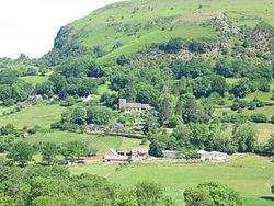
Cwmyoy, on the slope of Hatterrall Hill
Monmouthshire UK location map.svg
Red pog.svg
Cwmyoy
Location within Monmouthshire
OS grid reference SO299232
Principal area
Preserved county
Country Wales
Sovereign state United Kingdom
Post town ABERGAVENNY
Postcode district NP7
Dialling code 01600
Police Gwent
Fire South Wales
Ambulance Welsh
UK Parliament
Senedd Cymru – Welsh Parliament
List of places
UK
Wales
Monmouthshire
51°54′10″N3°01′13″W / 51.90291°N 3.02030°W / 51.90291; -3.02030

Cwmyoy is an extensive rural parish in Monmouthshire, Wales (Welsh : Cwm Iou, for the valley and parish; Welsh : Cwm-iou, for the village). The standard Welsh name is Cwm Iau or Cwm-iau. In the Gwentian dialect of Welsh that was spoken here until the late 1800s, the name was pronounced as Cwm Iou ('ou', also spelt informally 'oi', for standard 'au' is a common feature of south Wales Welsh). The 'English' name is in fact this local dialect form in a more English spelling. The name of the valley probably originates from the Welsh word iau meaning yoke, in reference to the shape of the hill surrounding it. [1]

Contents

The village of Cwmyoy is 7 miles (11 km) north of Abergavenny and 4 miles (6.4 km) south of Llanthony in the Vale of Ewyas in the Black Mountains. It is within the Brecon Beacons National Park, in an upland location just below the broad ridge of Hatterrall Hill, which carries the Wales–England border and Offa's Dyke Path.

The parish

The parish is nearly 8 miles (13 km) long and 1 mile (1.6 km) broad, and includes Llanthony as well as Cwmyoy itself. In 1893, an area in the neighbouring valley of the Grwyne Fawr, known in Welsh as Ffwddog and in English as the Fothock, which had been an exclave of Herefordshire, was transferred into the parish. [2]

Local amenities

The Cwmyoy area is popular for hillwalking and pony trekking. Llanthony Priory, Capel-y-ffin and Gospel Pass are all accessed by passing below Cwmyoy village.

Cwmyoy also has a small village hall which is run as a registered charity. [3]

St Martin's Church

St Martin's Church St Martin's Church In Cwmyoy.jpg
St Martin's Church

Cwmyoy is best known for St Martin's Church, a stone parish church standing on a steep hillside on the east side of the valley and which has been subject to slippage. It has been called the "most crooked church in Great Britain." [4] [5] Local historian Fred Hando (1958) calls it "the Church below the Landslide" and describes the chancel as "a remarkable example of a weeping chancel... the nave represents our Lord's body, and the deflected chancel His head fallen sideways in death." He notes that the whole chancel, not just its axis, is out of line, suggesting it was intentionally built this way and is not the result of the slippage. [6]

Related Research Articles

<span class="mw-page-title-main">Trellech</span> Human settlement in Wales

Trellech is a village and parish in Monmouthshire, south-east Wales. Located 5 miles (8 km) south of Monmouth and 4 miles (6.4 km) north-north-west of Tintern, Trellech lies on a plateau above the Wye Valley on the southern fringes of 320 acres (130 ha) of woodland in an Area of Outstanding Natural Beauty. Three Bronze Age standing stones are situated in the village, known as Harold's Stones, which overlook the historic church of St Nicholas, a Grade I listed building.

<span class="mw-page-title-main">Christchurch, Newport</span> Human settlement in Wales

Christchurch is a village located at the top of Christchurch Hill in the Caerleon ward and community of the city of Newport, South Wales. The top of the hill affords panoramic views both towards the Bristol Channel in the south and through the Vale of Usk and into the Monmouthshire countryside to the north. The road, which runs along the crest of the hill, runs westwards to Newport and eastwards towards Caerleon and Catsash.

<span class="mw-page-title-main">Vale of Ewyas</span> Valley in Monmouthshire, Wales, UK

The Vale of Ewyas is the steep-sided and secluded valley of the River Honddu, in the Black Mountains of Wales and within the Brecon Beacons National Park. As well as its outstanding beauty, it is known for the ruins of Llanthony Priory, and for several noteworthy churches such as those at Capel-y-ffin and Cwmyoy. It is sometimes referred to as the "Llanthony Valley" as Llanthony is the village situated at the valley centre.

<span class="mw-page-title-main">Mathern</span> Human settlement in Wales

Mathern is a historic community (parish) and village in Monmouthshire, south east Wales, about 3 miles (4.8 km) south west of the town of Chepstow, close to the Severn estuary, the Bristol Channel and the M48 motorway. The village is designated as a Conservation Area. It is now bisected by the motorway, which passes over the road through the village, with the original village located to the south and the more recent development, known as Newton Green, to the north.

<span class="mw-page-title-main">Llanvihangel Crucorney</span> Human settlement in Wales

Llanvihangel Crucorney is a small village in the community (parish) of Crucorney, Monmouthshire, Wales. It is located 5 miles (8.0 km) north of Abergavenny and 18 miles (29 km) south-west of Hereford, England on the A465 road.

<span class="mw-page-title-main">Llangattock-Vibon-Avel</span> Human settlement in Wales

Llangattock-Vibon-Avel is a rural parish and former community, now in the community of Whitecastle in Monmouthshire, south-east Wales, in the United Kingdom. It is located 5 miles (8.0 km) west of Monmouth and some 13 miles (21 km) east of Abergavenny, just off the B4233 old road between the two. Villages within the former community include Llangattock itself, Skenfrith, Rockfield, and Newcastle.

<span class="mw-page-title-main">Tredunnock</span> Human settlement in Wales

Tredunnock is a small village in Monmouthshire, south east Wales, in the United Kingdom. Tredunnock is located four miles (6.4 km) northeast of Caerleon and four miles south of Usk.

<span class="mw-page-title-main">Llangwm, Monmouthshire</span> Human settlement in Wales

Llangwm is a small rural village and former community, now in the community of Llantrisant Fawr, in Monmouthshire, south east Wales. It is located 3 miles (4.8 km) east of Usk, on the B4235 Chepstow to Usk road. The main village is at Llangwm Uchaf, with a smaller and more dispersed settlement about 1 mile (1.6 km) to the north-east at Llangwm Isaf .The other settlement in the community is Llansoy. In 2022 the community was abolished and merged with Llantrisant Fawr.

<span class="mw-page-title-main">Llantrisant, Monmouthshire</span>

Llantrisant is a village in Monmouthshire, south east Wales, United Kingdom. The community population at the 2011 census was 475.

Ewyas was a possible early Welsh kingdom which may have been formed around the time of the Roman withdrawal from Britain in the 5th century. The name was later used for a much smaller commote or administrative sub-division, which covered the area of the modern Vale of Ewyas and a larger area to the east including the villages of Ewyas Harold and Ewyas Lacy.

<span class="mw-page-title-main">St Pierre, Monmouthshire</span> Human settlement in Wales

St Pierre is a former parish and hamlet in Monmouthshire, south east Wales, 3 miles (4.8 km) south west of Chepstow and adjacent to the Severn Estuary. It is now the site of a large golf and country club, the Marriott St Pierre Hotel & Country Club, which was previously a large manor house and deer park belonging to the Lewis family.

Llanfihangel Tor-y-Mynydd is a small rural village in the community of Devauden, Monmouthshire, Wales. It is located within the Vale of Usk, about 9 miles south west of Monmouth and 6 miles east of the town of Usk, between the villages of Devauden and Llansoy.

<span class="mw-page-title-main">St David's Church, Llangeview</span> Church in Monmouthshire, Wales

St David's Church, Llangeview, is a redundant church sited in a round churchyard adjacent to the junction of the A449 and A472 roads 1 mile (1.6 km) to the east of the town of Usk in Monmouthshire, Wales. It has been designated by Cadw as a Grade I listed building, and is under the care of the Friends of Friendless Churches. It is Grade I listed because of its "exceptional interior" including a 15th-century rood-loft and "rare pre-Victorian box pews and fittings". The church stands in a churchyard that is almost circular, and is surrounded by a bank and the traces of a ditch.

<span class="mw-page-title-main">Fred Hando</span> Welsh writer, artist, teacher, and historian

Frederick James Hando MBE was a Welsh writer, artist and schoolteacher from Newport. He chronicled the history, character and folklore of Monmouthshire, which he also called Gwent, in a series of nearly 800 newspaper articles and several books published between the 1920s and 1960s.

<span class="mw-page-title-main">St Martin's Church, Cwmyoy</span> Church in Monmouthshire, Wales

The Church of St Martin, Cwmyoy, Monmouthshire, Wales, was begun in the 12th century, although most of the current structure dates from the 13th century. The church is most notable for its extreme tilt, the result of a landslide. This has led to many attempts to strengthen the church and prevent its collapse, through the use of massive tie beams and buttresses. The church is in the Gothic style, and has a chancel, nave, south porch, and western tower. A round-headed north window dates to the 12th century, and the nave roof has been dated to the late 13th or early 14th century. St Martin's is a Grade I listed building and an active parish church. It is dedicated to St Martin of Tours.

<span class="mw-page-title-main">Grade I listed buildings in Monmouthshire</span>

Monmouthshire is a county and principal area of Wales. It borders Torfaen and Newport to the west; Herefordshire and Gloucestershire to the east; and Powys to the north. The largest town is Abergavenny, with the other major towns being Chepstow, Monmouth, and Usk. The county is 850 km2 in extent, with a population of 95,200 as of 2020. The present county was formed under the Local Government (Wales) Act 1994, which came into effect in 1996, and comprises some sixty percent of the historic county. Between 1974 and 1996, the county was known by the ancient title of Gwent, recalling the medieval Welsh kingdom. In his essay on local government in the fifth and final volume of the Gwent County History, Robert McCloy suggests that the governance of "no county in the United Kingdom in the twentieth century was so transformed as that of Monmouthshire".

<span class="mw-page-title-main">St Cenedlon's Church, Rockfield</span> Church located in Monmouthshire, Wales

St Cenedlon's is a parish church in the village of Rockfield, Monmouthshire, Wales. The dedication to St Cenedlon is unusual and the history of the saint is obscure. Some sources suggest that she was a daughter of Brychan king of Brycheiniog while others identify her as the wife of King Arthfael ab Ithel, king of Glywysing. The existing church dates from the Middle Ages but only the tower remains from that period. After the English Reformation, the surrounding area of north Monmouthshire became a refuge for Catholics and Matthew Pritchard (1669-1750), Roman Catholic bishop and Vicar Apostolic of the Western District is buried at the church. By the mid-19th century the church was in ruins and a complete reconstruction was undertaken by the ecclesiastical architects John Pollard Seddon and John Prichard in around 1860. St Cenedlon's is an active parish church in the Diocese of Monmouth. It is designated by Cadw as a Grade II listed building.

<span class="mw-page-title-main">St Tewdric's Church</span> Church

St Tewdric's Church is a Church in Wales parish church in Mathern, Monmouthshire, Wales. It is purportedly built over the resting place of Saint Tewdrig for whom it is named. A church has been located on the site since the 6th century. It was reconstructed by the Normans in the Early English style, and later was renovated by the Victorians. It is a Grade I listed building.

<span class="mw-page-title-main">St David's Church, Llanthony</span> Church in Monmouthshire, Wales

St David's Church is a medieval structure at Llanthony Priory. Established as a church in the sixteenth century, and restored in the late nineteenth century, the church became a Grade I-listed building on 1 September 1956.

<span class="mw-page-title-main">St Mary's Church, Nash</span> Church in Nash, Wales

The Church of St Mary the Virgin, Nash is the parish church of the village of Nash, situated about 3 kilometres (1.9 mi) south of the city of Newport, Wales. Described as "the cathedral of the moors" by Monmouthshire historian Fred Hando, the large church is medieval in origin, with additions and restorations dating from the 18th and 19th centuries. Newman describes the 15th-century steeple as "unique in South East Wales". Since 3 January 1963 it has been designated a Grade I listed building primarily due to its "medieval tower with fine spire."

References

  1. Owen, H. W.; Morgan, R. (2007). Dictionary of the Place-names of Wales. Llandyssul: Gomer Press.
  2. Kelly's Directory of Monmouthshire. 1901.
  3. "Cwmyoy Memorial Hall". OpenCharities. 13 June 2015. Retrieved 20 October 2015.
  4. Slawych, Diane (19 October 2011). "Weird, wonderful Wales". Toronto Sun . Archived from the original on 19 September 2016. Retrieved 12 February 2012.
  5. "St Martin's Cwmyoy". The Vicarage, St Teilo's church with Bettws Chapel. Retrieved 3 September 2022.
  6. Hando, Fred (1958). Out and About in Monmouthshire. Newport: R. H. Johns Ltd. OCLC   30235598.