River Keekle

Last updated

The River Keekle meets the River Ehen The Keekle meets the Ehen - geograph.org.uk - 78632.jpg
The River Keekle meets the River Ehen

The River Keekle is a river running through the English county of Cumbria.

The source of the Keekle is to be found at Keekle Head Farm on High Park between Gilgarran and Asby. From there, the river moves gradually southwards via former open cast mine between Frizington and Whitehaven, past the hamlet of Keekle, to Cleator, where it becomes subsumed by the River Ehen. The river is noted for its occasional abundance of salmon.

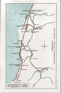
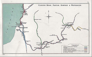
Oatlands Pit was sunk at Keekle Head in 1880 by The Moresby Coal Company which also built the pit terraces of Pica Village. The pit was sunk approx 500 yards south east of Pica. It was served by the Rowrah Branch of the Cleator to Workington railway. Production at Oatlands was suspended in 1930 with closure in 1932 and final abandonment in 1934.

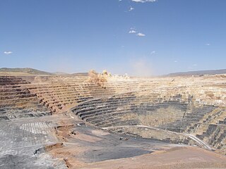
In the 1980s, Oatlands became part of the extensive open cast coal mining operation working from Keekle Head. The River Keekle valley was an open cast coal mining site and the site was later used to bury mine spoil and other waste.

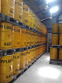
In 2010, there was lobbying against plans for dumping of low-level nuclear waste at the former open cast site at Keekle Head. [1] In 2012, Cumbria County Council rejected proposals by Endecom (owned by recycling and waste management company Sita) to build a repository for low level and very low level radioactive waste on the site of the former coal mine at Keekle Head. The council said the plan would have an "unacceptable impact" on the surrounding landscape. Endecom appealed against the rejection, triggering a two-week-long public inquiry, held in Kendal. There was strong opposition to the proposal to put radioactive waste in the site of the former open cast mine from Radiation Free Lakeland [2] and others. In 2013, a fresh inquiry was held. [3]

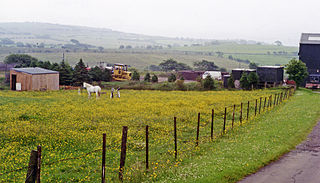
In the 1990s, a 2.5 km stretch of the river was lined with plastic to protect it from potential mine water contamination and because of fears that possible future erosion could expose deeply buried mine waste underneath. Over the years, this plastic liner began to degrade and break up, with pieces being washed downstream, creating blockages, localised flooding and plastic pollution in the River Keekle, as well as posing a threat to the downstream River Ehen – a Site of Special Scientific Interest and a Special Area of Conservation. During 2019 and 2020, the West Cumbria Rivers Trust carried out a £1.5 million project to remove the plastic liner and restore the riverbed with funding from the European Agricultural Fund for Rural Development's Water Environment Grant and the Environment Agency's River Restoration Programme. Around 150 tonnes of plastic was removed, with the sheets shredded, cleaned and recycled. Some of the plastic has been made into a bench and picnic table at Walkmill Community Woodland car park to mark the project's success. The river is re-naturalising itself and evidence of natural gravel, cobbles and sediment deposition can now be seen. The stretch of river has the potential to become a great habitat for people and wildlife. [4] [5]

Related Research Articles

Radioactive waste Unwanted or unusable radioactive materials

Radioactive waste is a type of hazardous waste that contains radioactive material. Radioactive waste is a result of many activities, including nuclear medicine, nuclear research, nuclear power generation, rare-earth mining, and nuclear weapons reprocessing. The storage and disposal of radioactive waste is regulated by government agencies in order to protect human health and the environment.

Open-pit mining Surface mining technique

Open-pit mining, also known as open-cast or open-cut mining and in larger contexts mega-mining, is a surface mining technique of extracting rock or minerals from the earth from an open-air pit, sometimes known as a borrow.

Deep geological repository Long term storage for radioactive and hazardous waste

A deep geological repository is a way of storing hazardous or radioactive waste within a stable geologic environment. It entails a combination of waste form, waste package, engineered seals and geology that is suited to provide a high level of long-term isolation and containment without future maintenance. This will prevent any radioactive dangers. A number of mercury, cyanide and arsenic waste repositories are operating worldwide including Canada and Germany and a number of radioactive waste storages are under construction with the Onkalo in Finland being the most advanced.

Drigg Village in Cumbria, England

Drigg is a village situated in the civil parish of Drigg and Carleton on the West Cumbria coast of the Irish Sea and on the boundary of the Lake District National Park in the Borough of Copeland in the county of Cumbria, England.

Cleator Human settlement in England

Cleator is a village in the English county of Cumbria and within the boundaries of the historic county of Cumberland.

Workington Central railway station Disused railway station in Cumbria, England

Workington Central railway station was opened by the Cleator and Workington Junction Railway (C&WJR) in 1879 to serve the town of Workington in Cumberland, England. It was situated almost half a mile nearer the town centre than its rival Workington station.

Rowrah Human settlement in England

Rowrah is a village in Cumbria, England, and spans the civil parishes of Arlecdon and Frizington and Lamplugh. The majority of Rowrah is within Arlecdon and Frizington. The parish boundaries are formed from the Windergill Beck and Colliergate Beck: as such nine properties, Rowrah Hall Farm, Rowrah Hall, Ainsdale House, Rowrah Head, four properties on Pheasants Rise and Rowrah Station technically fall within Lamplugh.

Cleator Moor West railway station Disused railway station in Cumbria, England

Cleator Moor West railway station was opened as "Cleator Moor" by the Cleator and Workington Junction Railway (C&WJR) in 1879. It served the growing industrial town of Cleator Moor, Cumbria, England.

High Harrington railway station Disused railway station in Cumbria, England

High Harrington railway station was opened by the Cleator and Workington Junction Railway (C&WJR) in 1879. It was situated half a mile south of Harrington Junction on the company's main line. and served what was then the eastern extremity of Harrington in Cumbria, England. The station is not to be confused with the current Harrington station a kilometre away on the coastal line.

Arlecdon railway station Disused railway station in Cumbria, England

Arlecdon railway station served the village of Arlecdon in the former English county of Cumberland, now part of Cumbria.

Coal mining in the United Kingdom Fossil fuel from underground

Coal mining in the United Kingdom dates back to Roman times and occurred in many different parts of the country. Britain's coalfields are associated with Northumberland and Durham, North and South Wales, Yorkshire, the Scottish Central Belt, Lancashire, Cumbria, the East and West Midlands and Kent. After 1972, coal mining quickly collapsed and had practically disappeared by the 21st century. The consumption of coal – mostly for electricity – fell from 157 million tonnes in 1970 to 18 million tonnes in 2016, of which 77% was imported from Colombia, Russia, and the United States. Employment in coal mines fell from a peak of 1,191,000 in 1920 to 695,000 in 1956, 247,000 in 1976, 44,000 in 1993, and to 2,000 in 2015.

Moresby Junction Halt railway station was opened by the Cleator and Workington Junction Railway (C&WJR) in 1910. Very few people lived near the halt, which served nearby Walkmill Colliery and coke ovens in Cumbria, England.

Keekle Colliers' Platform railway station was opened by the Cleator and Workington Junction Railway (C&WJR) in July 1910, closed the following January, reopened in June 1913 then closed for good on 1 October 1923. The halt was provided to enable residents of the isolated Keekle Terrace, less than 100 yds from the track, to get to and from work at the equally isolated Walkmill Colliery and coke ovens in Cumbria, England. The Platform is not shown by Jowett.

Moresby Parks railway station Disused railway station in Cumbria, England

Moresby Parks railway station was opened by the Cleator and Workington Junction Railway (C&WJR) in 1879. It was situated just north of the summit of the company's main line and served the scattered community of Moresby Parks in Cumbria, England.

Distington railway station Disused railway station in Cumbria, England

Distington railway station was opened jointly by the Cleator and Workington Junction Railway (C&WJR) and the LNWR and Furness Joint Railway on 1 October 1879. It was situated on the northern edge of the village of Distington, Cumbria, England, where the C&WJR's north–south main line crossed the Joint Line's east–west Gilgarran Branch.

Buckhill Colliery Halt railway station Disused railway station in Cumbria, England

Buckhill Colliery Halt railway station was an unadvertised halt for workers at Buckhill Colliery north east of Camerton, near Cockermouth in Cumberland, England.

Oatlands railway station Disused railway station in Cumbria, England

Oatlands railway station served the village of Pica and Oatlands Colliery in the former English county of Cumberland, now part of Cumbria.

Parton Halt railway station Disused railway station in Cumbria, England

Parton Halt railway station was opened by the LNWR and FR Joint Railway in January 1915 and closed by the LMSR fourteen years later in 1929.

Bigrigg Human settlement in England

Bigrigg is a village in the English county of Cumbria and within the boundaries of the historic county of Cumberland.

References

  1. Protesters argue against the burial of low-level N-waste 11 August 2010 www.whitehavennews.co.uk, accessed 15 November 2021
  2. "Radiation Free Lakeland". Archived from the original on 11 October 2010.[ dead link ]
  3. Inquiry over Keekle Head nuclear waste plan 25 June 2013 www.bbc.co.uk, accessed 15 November 2021
  4. River Keekle restoration westcumbriariverstrust.org, accessed 15 November 2021
  5. Saving Cumbria's plastic-lined river www.bbc.co.uk, accessed 15 November 2021

Commons-logo.svg Media related to River Keekle at Wikimedia Commons

Coordinates: 54°30′06″N3°31′39″W / 54.5017°N 3.5276°W / 54.5017; -3.5276