Startforth Rural District was a rural district in the North Riding of the historic county of Yorkshire in the Pennines of northern England.
The River Wyre is a river in Lancashire, England, United Kingdom, which flows into the Irish Sea at Fleetwood. It is approximately 28 miles (45 km) in length. The river is a County Biological Heritage Site and has a sheltered estuary which, from its northwest corner, penetrates deep into the almost square peninsula of the Fylde.

The River Swale in Yorkshire, England, is a major tributary of the River Ure, which becomes the River Ouse, that empties into the North Sea via the Humber Estuary. The river gives its name to Swaledale, the valley through which it flows.
Laithkirk is a small hamlet of three houses and a small church in County Durham, in England. All of the houses in Laithkirk are accessed by an unnamed road which connects the B6277 and the B6276. The hamlet is the final settlement that lies in Lunedale, before the Lune river joins with the Tees. It is situated in Teesdale between Mickleton and Bowbank, near to Middleton-in-Teesdale.
The River Wenning is a tributary of the River Lune, flowing through North Yorkshire and Lancashire.
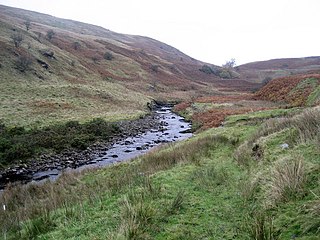
Lunedale is the dale, or valley, of the River Lune, on the east side of the Pennines in England, west of Middleton-in-Teesdale. Its principal settlements are Grassholme, Thringarth and Bowbank.

Liddel Water is a river running through southern Scotland and northern England, for much of its course forming the border between the two countries, and was formerly one of the boundaries of the Debatable Lands.

The River Belah is a river in the county of Cumbria in England. Its name derives from the Old English word Belge and means the "Roaring River".
Leck Beck is a watercourse in Lancashire with its source on Crag Hill in Cumbria between Leck Fell and Casterton Fell.
Artle Beck is a minor river of Lancashire.

Barbon Beck is a small river in Cumbria. It is a tributary of the River Lune.
Birk Beck is a minor river in Cumbria.
The River Browney is a river in County Durham, England, and the largest tributary of the River Wear.
The River Greta is a river in County Durham, England. It is a tributary of the River Tees and flows through the northern part of the old North Riding of Yorkshire. The name "Greta" derives from the Old Norse "Griótá", meaning "stony stream".

Murton is a small village and civil parish in the Eden District of Cumbria, England. The parish had a population of 330 in 2001, rising to 360 at the 2011 Census. Settlements within the parish include the villages of Hilton, Langton, Brackenber and various small farms, houses and cottages. The town of Appleby-in-Westmorland is to the south-west.

Grains o' th' Beck Meadows is a Site of Special Scientific Interest in the Teesdale district of south-west County Durham, England. It consists of three traditionally-managed hay meadows in Upper Lunedale, on the north bank of the River Lune, a little under 6 km upstream of the Selset Reservoir dam. The site is enclosed by the Lune Forest SSSI.
Lune Forest is a Site of Special Scientific Interest covering an extensive area of moorland in the Teesdale district of west Durham, England. In the north, where it adjoins the Upper Teesdale and Appleby Fells SSSIs, it extends from Mickle Fell eastward almost as far as Harter Fell, above the hamlet of Thringarth. Its southern limit is marked by the River Balder, upstream from Balderhead Reservoir, where it shares a boundary with Cotherstone Moor SSSI to the south. Grains o' th' Beck Meadows and Close House Mine SSSIs are entirely surrounded by Lune Forest, but do not form part of it.

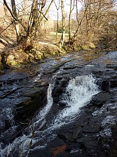
Harden Beck is a stream that flows from Hewenden Reservoir, over Goit Stock Waterfall to the River Aire in Bingley, West Yorkshire. The route starts out further up the valley as Denholme Beck, Hewenden Beck and Hallas Beck. Its waters are fed by Thornton Moor Reservoir, Stubden Reservoir, Doe Park Reservoir and Hewenden Reservoir.

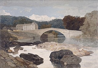
The Crook o' Lune or Crook of Lune, about three miles north-east of Lancaster, Lancashire, is a horseshoe bend of the River Lune, which here meanders through meadows and low hills into a wooded gorge. It has long been noted for its views eastward up the Lune valley to Hornby Castle and, in the far distance, Ingleborough and other Pennine fells. It was painted by J. M. W. Turner and its scenic attractions were celebrated by such writers as Thomas Gray and William Wordsworth. In recent years the Sunday Times has claimed that it "rivals the beauty of the Lake District". It lies within the Forest of Bowland Area of Outstanding Natural Beauty and the Lune Millennium Park. The river is crossed here by two former railway viaducts and one road bridge, all being Grade II listed buildings.
