River Rwizi

Last updated
River Rwizi
River Rwizi.png
Waste in River Rwizi
Rivers of South West Uganda.png
Rivers in South West Uganda with the Ruizi (lower left center).
Location
Country Uganda
Physical characteristics
SourceBuhweju hills
Mouth  
  location
To Lake Victoria via the drainage systems of Lake Mburo, Lake Kachera and Kijanebalola.
  coordinates
0°41′33″S30°54′20″E / 0.69250°S 30.90556°E / -0.69250; 30.90556
  elevation
1,258 m (4,127 ft)
Basin size2,282 km2 (881 sq mi) [1]
Discharge 
  location Mbarara [2]
  average25.4 m3/s (900 cu ft/s)
  minimum16.5 m3/s (580 cu ft/s)
  maximum35.7 m3/s (1,260 cu ft/s)
Basin features
Progression Lake VictoriaWhite NileNileMediterranean Sea
River system Nile basin

River Rwizi is a river located in South Western Uganda in district called Mbarara. River Rwizi is a river located in southwestern Uganda. It is the second-longest river in Uganda, after the Nile River. The river originates in the hills of Buhweju District and flows through the districts of Sheema, Bushenyi, Ntungamo, Rwampara, Mbarara, Isingiro, Kiruhura, Lyantonde, Rakai, and Kyotera. It eventually empties into Lake Victoria. [3] Many swamps feed river Rwizi, including Nyakafumura, part of the Mushasha water basin, and Kanyabukanja wetland. These marshes function as water reservoirs or catchments, gently releasing water into the river to support the surrounding population. [4] [5] [6] [7] [8] [9]

Contents

History

The river has been an important part of the history of Uganda for centuries. It was used by the Buganda Kingdom as a transportation route and a source of water. The river was also important for the development of agriculture in the region.

In the 19th century, the river was used by the British Empire as a way to control the Buganda Kingdom. The British built a number of forts along the river, and used them to control trade and travel.

The river has also been important in the development of tourism in Uganda. Lake Mburo National Park, which is located on the banks of the river, is a popular tourist destination. The dense vegetation of papyrus and other marsh grasses near River Rwizi worked as water filters, catchment, and managed flooding in the area in the early 1950s. [5]

Overview

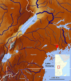
It originates from Buhweju hills with various tributaries from various Nkore hills including Ntungamo and Sheema hills which join it. It pours its water in Lake Victoria via the drainage systems of Lake Mburo, Lake Kachera and Kijanebalola. [6]

The River Rwizi plays a crucial role in supplying water for both domestic and industrial purposes to various towns in the area, including Mbarara, Bwizibwera, Sanga, and Biharwe. Additionally, it serves as an important transportation route and offers opportunities for fishing and recreation. [7]

However, the river is currently facing significant challenges. Climate change has led to drying out of the river, impacting its water levels and availability. Furthermore, the proliferation of water hyacinth, a plant known for inducing water pollution through the release of excess nutrients, has further exacerbated the river's deterioration.

The destruction of the river is also attributed to the widespread issue of land grabbing along its banks. Unregulated encroachment on the river's territory has contributed to its degradation and loss of natural habitat.

Moreover, untreated waste disposal poses a significant threat to the river's health. Various sources, including industries like the iron and steel sector in Kakoba and Mbarara, as well as hospitals, contribute to water pollution through the dumping of untreated waste products. This pollution further deteriorates the quality of the river water.

Addressing these challenges and implementing measures to conserve and restore the River Rwizi's health is essential to ensure sustainable water supply, preserve its ecosystem, and maintain its importance as a transportation route, fishing ground, and recreational area.

Points of interest

The people living around the river Rwizi engage in a variety of economic activities that take place along and within its vicinity. One significant activity is farming, where the fertile land near the river has led the local community to encroach upon the wetlands for crop cultivation. This has resulted in increased yields and opportunities for livestock rearing.

Sand deposits and vegetation around river Rwizi in Mbarara in western Ugand Sand deposits and vegetation around river Rwizi in Mbarara in western Uganda 01.jpg
Sand deposits and vegetation around river Rwizi in Mbarara in western Ugand

Another economic endeavor is the production of bricks. Utilizing the river sand, people in the area are involved in the creation of bricks, which are sold or used for constructing dwellings.

Papyrus harvest is yet another livelihood pursued by the community. They gather papyrus from the river to craft mats, baskets, chairs, and ropes, providing them with a means of sustenance.

Fishing is a long-standing practice in the region, with individuals utilizing the river to catch fish for both personal consumption and for sale in local markets.

River Rwizi in Mbarara Vegetation and human activity around River Rwizi in Mbarara 23.jpg
River Rwizi in Mbarara
Papyrus plants in River Rwizi River Rwizi Vegetation 05.jpg
Papyrus plants in River Rwizi

It's worth noting that the river Rwizi holds several notable landmarks. The Rwizi Water Falls can be found in Katete, Mbarara, offering a picturesque sight for visitors. In addition, there is Katete Bay, which is located nearby. The Ngaro Mwenda Bridge, situated three kilometers off Kabale Road in Mbarara, serves as a significant crossing point over the river. Lastly, the area known as Rwizi Meanders is situated in close proximity to Mbarara University. [3] [7] [6]

Degradation

River Rwizi is grappling with a lot of issues, including pollution and climate change. These concerns endanger the river's ecosystem and its ability to deliver water and other resources to Ugandans. The river is challenged by the following;

Sewage ponds located near River Rwizi in Katete in Mbarara in western Uganda Sewage ponds of Katete in Mbarara in western Uganda 09.jpg
Sewage ponds located near River Rwizi in Katete in Mbarara in western Uganda

Pollution: Agricultural runoff, industrial trash, and sewage pollute the river. This pollution is wreaking havoc on the river's environment and rendering the water hazardous to drink.

Deforestation: The watershed basin of the river is being deforested at an alarming rate. This deforestation causes soil erosion and siltation, which clogs the river and makes breeding difficult for fish.

Sand deposits and vegetation around river Rwizi in Mbarara in western Uganda Sand deposits and vegetation around river Rwizi in Mbarara in western Uganda 03.jpg
Sand deposits and vegetation around river Rwizi in Mbarara in western Uganda

Climate change is causing the river's water levels to fluctuate more irregularly. This makes crop planning tough for farmers and water access problematic for residents.

Conservation

Several conservation efforts are underway to protect the river and its ecology. Among these attempts are:

Reforestation: To minimize soil erosion and siltation, trees are being planted in the river's catchment region.

Pollution control: Wastewater treatment plants are being constructed to reduce pollution entering the river. People living near the river are being educated on the importance of conservation and how they may help safeguard the river.

The Rwizi River has lost up to 80% of its water, and inhabitants are now using it as a road. This is due to illicit land acquisition in the river's catchment region of 8,700 square kilometers. Over 200 persons have illegally purchased over 500 hectares of land along the River Rwizi, destroying the river's level, which has dropped to two and a half meters below where it used to be.

Up to five million people rely on the river, including residents in Mbarara who have no other source of piped water but the Rwizi. The invasive water hyacinth has added to the river's congestion from Ndeija in Mbarara District to Sango Bay in Rakai. Poor agricultural practices are to blame. [8]

A committee for the rehabilitation of the Rwizi catchment has been formed, with representatives from the districts that share the river. There are continuing initiatives to restore the river's catchment and water level through stakeholder engagement.

Several entities have created gabion walls at its factory in Ruharo, Mbarara, as part of this collaboration, to stabilize the river banks and prevent loose soils from collapsing into the river and silting it. The gabions stabilize the banks to prevent silting and also stabilize the water levels to allow volume monitoring to determine how much water is in the river. According to the Ministry of Water and Environment, the government has taken statutory steps to combat further environmental degradation and restore degraded regions around the country. [9] There is a cabinet order to invalidate all wetlands land titles, and the process is ongoing. People's land titles in gazetted forest reserves are being revoked. We are attempting to demarcate all wetlands in Uganda, and the ministry is educating people about the hazards of environmental degradation. [4]

The future of the River Rwizi is unpredictable. The river has major challenges, and it is unknown whether the river will be able to overcome them. However, the conservation efforts ongoing are encouraging, and there is optimism that the river can be preserved for future generations. [10] [11]

Save River Rwizi Marathon

Preparations for the Save River Rwizi Marathon 2023 are beginning, and the ABAHUMUZA Development Group, which organizes this important event, is urging everyone to work together to save the only water supply that is critical to the livelihoods of over 6 million people.

The inaugural marathon was held in 2022, and the revenues were used to clean and restore the River Rwizi by planting trees along its banks.

The 2023 marathon will take place on Sunday, July 30 at the Mbarara Golf Course Grounds, beginning at 7 a.m. Among those participating in this event are the Ministry of Water and Environment, NBS Television, Taasa Obutonde, Lato Milk, National Water and Sewerage Corporation, and Mbarara City Council. [12] [13] [14] [15] [16] [17] [18] [19] [20]

Related Research Articles

<span class="mw-page-title-main">Ankole</span> Former country

Ankole was a traditional Bantu kingdom in Uganda and lasted from the 15th century until 1967. The kingdom was located in south-western Uganda, east of Lake Edward.

<span class="mw-page-title-main">Kissimmee River</span> River in Florida, United States

The Kissimmee River is a river in south-central Florida, United States that forms the north part of the Everglades wetlands area. The river begins at East Lake Tohopekaliga south of Orlando, flowing south through Lake Kissimmee into the large, shallow Lake Okeechobee. Hurricane-related floods in 1947 prompted channelization of the meandering lower stretch, completed by 1970. The straightened course reduced wetland habitat and worsened pollution. In response, efforts since the 1990s have partially restored the river's original state and revitalized the ecosystem, as part of the broader restoration of the Everglades.

<span class="mw-page-title-main">Ntungamo District</span> District in Western Uganda, Uganda

Ntungamo District is a district in Western Uganda. Like most Ugandan districts, it named after its 'chief town', Ntungamo, the location of the district headquarters. Ntungamo was elevated to a district on 5th May 1993.

<span class="mw-page-title-main">Mbarara district</span> District in Western Uganda, Uganda

Mbarara District is a district in South Western Uganda. In 2019, the Ugandan Cabinet approved part of Mbarara District, the then-Mbarara municipality, to be upgraded to city status effective July 2020.

<span class="mw-page-title-main">Bushenyi District</span> District in Western Uganda, Uganda

Bushenyi District is a district in Western Uganda. Like many other Ugandan districts, it is named after its chief town, Bushenyi, where the district headquarters are located.

<span class="mw-page-title-main">Mbarara</span> Place in Western Region, Uganda

Mbarara City is a city in the Western Region of Uganda and the second largest city in Uganda after Kampala. The city is divided into 6 boroughs of Kakoba Division, Kamukuzi Division, Nyamitanga Division, Biharwe Division, Kakiika Division, Nyakayojo Division. It is the main commercial centre of most of south western districts of Uganda and the site of the district headquarters. In May 2019, the Uganda's cabinet granted Mbarara a city status, which started on 1 July 2020.

<span class="mw-page-title-main">Lake Mburo National Park</span> National park in Uganda

Lake Mburo National Park is a national park located in Nyabushozi County, Kiruhura District in Uganda.

Mbarara High School (MHS), also known as Chaapa is a boys-only boarding middle and high school located in Ruharo Mbarara City in Mbarara District in Western Uganda.

<span class="mw-page-title-main">Papyrus gonolek</span> Species of bird

The papyrus gonolek is a species of bird in the family Malaconotidae. It is found in Burundi, Democratic Republic of the Congo, Kenya, Rwanda, Tanzania, and Uganda. It has specialised habitat requirements, being restricted to papyrus swamps. Not yet a threatened species, it has become rare due to habitat loss and pollution.

<span class="mw-page-title-main">Lake Connewarre</span> Estuarine lake in Victoria, Australia

Lake Connewarre, a shallow estuarine 880-hectare (2,200-acre) lake on the Barwon River, is located on the Bellarine Peninsula southeast of Geelong in the Australian state of Victoria.

Ibanda is a town in the Western Region of Uganda. It is the main political, administrative, and commercial centre of Ibanda District and the site of the district headquarters. It started wayback in 1990s and was elevated from a trading centre to a town board, town council and in 2016 it was granted a Municipality status. The Municipal Council has three Divisions of Kagongo, Bisheshe and Bufunda with 21 wards of Kyaruhanga, Bufunda, Nyamirima, Nsasi, Kayenje, Kashangura, Rwenshuri, Kigarama, Rugazi, Rwobuzizi, Kakatsi, Bugarama, Karangara, Kabaare, Kanyansheko, Nyakatookye, Kyeikucu, Kikoni, Kagongo, Ruyonza and Katongore ward. Ibanda Municipal Council has over 230 villages. Ibanda Municipal council commenced its operations on 1 July 2016 after being elevated from a Town Council and other sub counties that were annexed to..

<span class="mw-page-title-main">Rudrasagar Lake</span> Lake in Tripura, India

Rudrasagar Lake, also known as Twijilikma, is a lake located in Melaghar, Tripura, India.

<span class="mw-page-title-main">Rubirizi District</span> District in Western Uganda, Uganda

Rubirizi District is a district in Western Uganda. Like most Ugandan districts, the district is named after its 'chief town', Rubirizi, where the district headquarters are located.

<span class="mw-page-title-main">Buhweju District</span> District in Western Uganda, Uganda

Buhweju District is a district in Western Uganda. It is one of the districts that constitute the Ankole sub-region. Its 'chief town', is Nsiika.

Nsiika is a town in Buhweju District, in Western Uganda. It is the main municipal, administrative and commercial center in Buhweju District, and is the location of the district headquarters.

Makenke is a neighborhood within Mbarara City, in the Western Region of Uganda.

Sanga, is an urban center in the Kiruhura District, Ankole sub-region, in the Western Region of Uganda.

Kazo is a district in Uganda's Western Region. It is located approximately 200 square kilometres (77 sq mi) west of Uganda's capital Kampala. It covers an area of 1,556 square kilometres (601 sq mi) and recorded a population of 177,054 in the 2014 Ugandan census. The capital of the district is the town of Kazo.

Lake Mburo-Nakivali Wetland System is a wetland located in Mbarara district, 60 km from Mbarara town in western Uganda, East Africa, bordering Tanzania and Rwanda. The system encompasses five lakes lying in the National park including Mburo being the largest, Kigambira, Mutukula, Kazuma and Bwara in the west-east location.

Lake Mburo is a freshwater lake located in western Uganda, situated within the Lake Mburo National Park. It is a prominent feature of the region, known for its scenic beauty and rich biodiversity.

References

  1. Basooma, Anthony; Teunen, Lies; Semwanga, Nathan; Bervoets, Lieven (2021). "Trace metal concentrations in the abiotic and biotic components of River Rwizi ecosystem in western Uganda, and the risks to human health". Heliyon. 7 (11): e08327. Bibcode:2021Heliy...708327B. doi: 10.1016/j.heliyon.2021.e08327 . PMC   8593446 . PMID   34816035.
  2. Vörösmarty, Charles J.; Fekete, B. M.; Tucker, B. A. (2004). "Monthly mean river discharge at gauging station Mbarara Water Supply". Pangaea. doi:10.1594/PANGAEA.218872.{{cite journal}}: Cite journal requires |journal= (help)
  3. 1 2 Mugira, Fredrick (2019-08-29). "Road River: The story of a river dried by illegal land acquisitions | Earth Journalism Network". earthjournalism.net. Retrieved 2023-06-19.
  4. 1 2 "River Rwizi on the verge of drying up". landportal.org. 2021-09-28. Retrieved 2023-06-19.
  5. 1 2 "How River Rwizi destruction has left Mbarara in a mess". Monitor. 2021-01-05. Retrieved 2023-06-19.
  6. 1 2 3 "Overview of River Rwizi". Archived from the original on 3 August 2014. Retrieved 19 January 2015.
  7. 1 2 3 "Road River: A Photo Story of a River Dried by Illegal Land Acquisitions". Pulitzer Center. Retrieved 2023-06-19.
  8. 1 2 Africa, Water Journalists (2019-08-20). "Road River: A photo story of a river dried by illegal land acquisitions". Water Journalists Africa. Retrieved 2023-06-19.
  9. 1 2 MATSIKO, PATRICK (2021-09-08). "Why Rwizi, Ankole's biggest river is drying up". The Observer - Uganda. Retrieved 2023-06-19.
  10. "Saving the endangered River Rwizi". New Vision. Retrieved 2023-06-19.
  11. "A river in intensive care". Green Economy Coalition. Retrieved 2023-06-19.
  12. Agaba, Nicholas. "Save River Rwizi Marathon 2023 Organisers Rally Ugandans to Join Efforts to Conserve Water Body". The Kampala Post. Retrieved 2023-06-19.
  13. "Save River Rwizi marathon preparations in high gear – Kampala Sun". 2023-06-17. Retrieved 2023-06-19.
  14. sqoopadmin (2023-06-16). "Second edition of 'Save River Rwizi' marathon returns – Sqoop – Get Uganda entertainment news, celebrity gossip, videos and photos" . Retrieved 2023-06-19.
  15. Marathon, Save River Rwizi. "Save River Rwizi Marathon". Hangspots. Retrieved 2023-06-19.
  16. mod_lato (2022-08-05). "Lato Milk successfully organised River Rwizi Marathon 2022". Lato Milk. Retrieved 2023-06-19.
  17. BigEyeUg1 (2023-06-17). "Save River Rwizi Marathon launched". BigEye.UG. Retrieved 2023-06-19.{{cite web}}: CS1 maint: numeric names: authors list (link)
  18. Admin (2023-05-26). "MBARARA: Save River Rwizi Marathon in high gear". Kigezi Post. Retrieved 2023-06-19.
  19. Times, The Ankole (2023-05-18). "Participate in the Save River Rwizi Marathon on July 30th". The Ankole Times. Retrieved 2023-06-19.
  20. iWitness (2023-04-24). "The Save Rwizi Marathon on in Mbarara City". Galaxy FM 100.2. Retrieved 2023-06-19.

Sources