Related Research Articles

The Ganges is a trans-boundary river of Asia which flows through India and Bangladesh. The 2,525 km (1,569 mi) river rises in the western Himalayas in the Indian state of Uttarakhand. It flows south and east through the Gangetic plain of North India, receiving the right-bank tributary, the Yamuna, which also rises in the western Indian Himalayas, and several left-bank tributaries from Nepal that account for the bulk of its flow. In West Bengal state, India, a feeder canal taking off from its right bank diverts 50% of its flow southwards, artificially connecting it to the Hooghly River. The Ganges continues into Bangladesh, its name changing to the Padma. It is then joined by the Jamuna, the lower stream of the Brahmaputra, and eventually the Meghna, forming the major estuary of the Ganges Delta, and emptying into the Bay of Bengal. The Ganges–Brahmaputra–Meghna system is the second-largest river on earth by discharge.

The Brahmaputra is a trans-boundary river which flows through Tibet (China), Northeastern India, and Bangladesh. It is known as Brahmaputra or Luit in Assamese, Yarlung Tsangpo in Tibetan, the Siang/Dihang River in Arunachali, and Jamuna River in Bengali. It is the 9th largest river in the world by discharge, and the 15th longest.
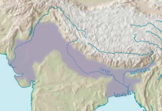
The Indo-Gangetic Plain, also known as the North Indian River Plain, is a 700-thousand km2 (172-million-acre) fertile plain encompassing northern regions of the Indian subcontinent, including most of modern-day northern and eastern India, most of eastern-Pakistan, virtually all of Bangladesh and southern plains of Nepal. Also known as the Indus–Ganga Plain, the region is named after the Indus and the Ganges rivers and encompasses a number of large urban areas. The plain is bounded on the north by the Himalayas, which feed its numerous rivers and are the source of the fertile alluvium deposited across the region by the two river systems. The southern edge of the plain is marked by the Deccan Plateau. On the west rises the Iranian Plateau. Many developed cities like Delhi, Dhaka, Kolkata, Lahore, Islamabad and Karachi are located in the Indo-Gangetic Plain.

Nagarjuna Sagar Dam is a masonry dam across the Krishna River at Nagarjuna Sagar which straddles the border between Palnadu district in Andhra Pradesh and Nalgonda district in Telangana. The dam provides irrigation water to the districts of Palnadu, Guntur, Nalgonda, Prakasam, Khammam, Krishna, and parts of West Godavari. It is also a source of electricity generation for the national grid.

The Indian rivers interlinking project is a proposed large-scale civil engineering project that aims to effectively manage water resources in India by linking rivers using a network of reservoirs and canals to enhance irrigation and groundwater recharge and reduce persistent floods in some parts and water shortages in other parts of the country. India accounts for 18% of global population and about 4% of the world's water resources. One of the solutions to solve the country's water woes is to link its rivers and lakes.

A johad, also known as a pokhar or a percolation pond, is a community-owned traditional harvested rainwater storage wetland principally used for effectively harnessing water resources in the states of Haryana, Rajasthan, Punjab, and western Uttar Pradesh of North India, that collects and stores water throughout the year, to be used for the purpose of recharging the groundwater in the nearby water wells, washing, bathing and drinking by humans and cattle. Some johads also have bricked or stones masonry and cemented ghat.
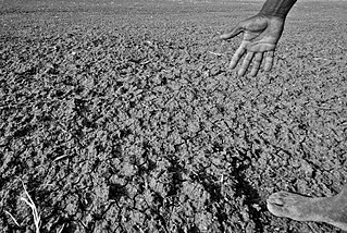
Drought has resulted in millions of deaths in India over the years. Indian agriculture is heavily dependent on the country's climate: a favorable monsoon is critical to securing water for irrigating India's crops. In parts of India, failure of the monsoons causes water shortages, resulting in poor yields. This is particularly true of major drought-prone regions southeastern Maharashtra, northern Karnataka, Andhra Pradesh, Odisha, Gujarat, Telangana, and Rajasthan.

Water resources in India includes information on precipitation, surface and groundwater storage and hydropower potential. India experiences an average precipitation of 1,170 millimetres (46 in) per year, or about 4,000 cubic kilometres (960 cu mi) of rains annually or about 1,720 cubic metres (61,000 cu ft) of fresh water per person every year. India accounts for 18% of the world's population and about 4% of the world's water resources. One of the proposed solutions to solve the country's water woes is the Indian rivers interlinking project. Some 80 percent of its area experiences rains of 750 millimetres (30 in) or more a year. However, this rain is not uniform in time or geography. Most of the rains occur during its monsoon seasons, with the northeast and north receiving far more rain than India's west and south. Other than rains, the melting of snow over the Himalayas after the winter season feeds the northern rivers to varying degrees. The southern rivers, however, experience more flow variability over the year. For the Himalayan basin, this leads to flooding in some months and water scarcity in others. Despite an extensive river system, safe clean drinking water as well as irrigation water supplies for sustainable agriculture are in shortage across India, in part because it has, as yet, harnessed a small fraction of its available and recoverable surface water resource. India harnessed 761 cubic kilometres (183 cu mi) (20 percent) of its water resources in 2010, part of which came from unsustainable use of groundwater. Of the water it withdrew from its rivers and groundwater wells, India dedicated about 688 cubic kilometres (165 cu mi) to irrigation, 56 cubic kilometres (13 cu mi) to municipal and drinking water applications and 17 cubic kilometres (4.1 cu mi) to industry.

Located in the Sahelian and Saharan zones, Mauritania has one of the poorest agricultural bases in West Africa. Most important to the rural economy has been the livestock subsector. Between 1975 and 1980, herding engaged up to 70 percent of the population, and sedentary farmers constituted about 20 percent of the population. The vast majority of the population lived in the southern one-third of the country, where rainfall levels were high enough to sustain cattle herding. Farming was restricted to the narrow band along the Senegal River where rainfall of up to 600 millimeters per year and annual river flooding sustained crop production as well as large cattle herds. In the dry northern two-thirds of the country, herding was limited to widely scattered pastoral groups that raised camels, sheep, and goats, and farming was restricted to date palms and minuscule plots around oases.

Agriculture in Sudan plays an important role in that country's economy. Agriculture and livestock raising are the main sources of livelihood for most of the Sudanese population. It was estimated that, as of 2011, 80 percent of the labor force were employed in that sector, including 84 percent of the women and 64 percent of the men.

Interbasin transfer or transbasin diversion are terms used to describe man-made conveyance schemes which move water from one river basin where it is available, to another basin where water is less available or could be utilized better for human development. The purpose of such water resource engineering schemes can be to alleviate water shortages in the receiving basin, to generate electricity, or both. Rarely, as in the case of the Glory River which diverted water from the Tigris to Euphrates River in modern Iraq, interbasin transfers have been undertaken for political purposes. While ancient water supply examples exist, the first modern developments were undertaken in the 19th century in Australia, India and the United States, feeding large cities such as Denver and Los Angeles. Since the 20th century many more similar projects have followed in other countries, including Israel and China, and contributions to the Green Revolution in India and hydropower development in Canada.
Bihar is India's most flood-prone state, with 76% of the population of North Bihar living under the recurring threat of devastating flooding. Bihar makes up 16.5% of India's flood-affected area and contains 22.1% of India's flood-affected population. About 73.06% of Bihar's geographical area, 68,800 square kilometres (26,600 sq mi) out of 94,160 square kilometres (36,360 sq mi), is affected. Each year, floods kill many and damage livestock and other assets worth millions. In total, floods have claimed 9,500 lives since the government started publishing figures in 1979. North Bihar districts are vulnerable to at least five major flood-causing rivers during monsoon – the Mahananda, Koshi, Bagmati, Burhi Gandak, and Gandak rivers – which originate in Nepal. Some South Bihar districts have also become vulnerable to floods, from the Son, Punpun, and Phalgu rivers. The 2013 flood affected over 5.9 million people in 3,768 villages in 20 districts in the state. The 2017 flood affected 19 districts in North Bihar, killing 514 people and affecting over 17 million.
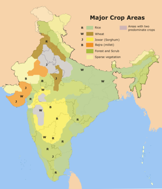
Rice production in India is an important part of the national economy.
Rengali dam is a dam located in Odisha, India. It is constructed across the Brahmani River in Rengali village, located 70 km from Angul in Angul district.

The Polavaram Project is an under construction multi-purpose irrigation project on the Godavari River in the Eluru District and East Godavari District in Andhra Pradesh. The project has been accorded National project status by the Central Government of India. Its reservoir back water spreads up to the Dummugudem Anicut and approx 115 km on Sabari River side. Thus back water spreads into parts of Chhattisgarh and Odisha States. It gives major boost to tourism sector in Godavari Districts as the reservoir covers the famous Papikonda National Park, Polavaram hydro electric project (HEP) and National Waterway 4 are under construction on left side of the river. It is located 40 km to the upstream of Sir Arthur Cotton Barrage in Rajamahendravaram City and 25 km from Rajahmundry Airport.

Irrigation in India includes a network of major and minor canals from Indian rivers, groundwater well based systems, tanks, and other rainwater harvesting projects for agricultural activities. Of these groundwater system is the largest. In 2013–14, only about 36.7% of total agricultural land in India was reliably irrigated, and remaining 2/3 cultivated land in India is dependent on monsoons. 65% of the irrigation in India is from groundwater. Currently about 51% of the agricultural area cultivating food grains is covered by irrigation. The rest of the area is dependent on rainfall which is most of the times unreliable and unpredictable.

The 2015 South India floods resulted from heavy rainfall generated by the annual northeast monsoon in November–December 2015. They affected the Coromandel Coast region of the South Indian states of Tamil Nadu and Andhra Pradesh. More than 500 people were killed and over 1.8 million people were displaced. With estimates of damages and losses ranging from nearly ₹200 billion (US$2 billion) to over ₹1 trillion (US$12 billion), the floods were the costliest to have occurred in 2015, and were among the costliest natural disasters of the year.

Following heavy rain in July and August 2017, the Indian state of West Bengal was affected by severe flooding. The floods were reported to have caused 50 deaths since 1 August and 8 deaths in the neighbouring state of Jharkhand.
The Brahmaputra floods refers to a catastrophic flood event that occurred in 2012 along the Brahmaputra River and its tributaries, as well as in subsequent years.

Beginning in May 2022, deadly floods hit northeastern India and Bangladesh. Over 9 million people in both countries have been affected, and around 300 people have been killed.
References
- ↑ "Home Page:National Water Development Agency".
- 1 2 3 4 Article at the-south-asian, additional text.