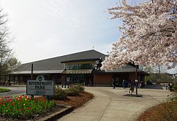
Riverfront Park (Salem, Oregon)

Last updated
Riverfront Park
Salem Riverfront Park entrance - Oregon.JPG
Entrance to the park with the building housing the carousel in the background, 2012
Riverfront Park (Salem, Oregon)
Location Salem, Oregon, U.S.
Coordinates 44°56′31″N123°02′35″W / 44.942°N 123.04316°W / 44.942; -123.04316
Area23 acres (9.3 ha)

Riverfront Park is a 23-acre park located along the Willamette River in Salem, Oregon, in the United States. [1] Features include the Riverfront Carousel (2001), A. C. Gilbert's Discovery Village, an amphitheatre, and Eco-Earth Globe , an outdoor sculpture and community art project completed in 2003. [1] It is located on former industrial land owned by the Boise Cascade corporation redeveloped as part of the Riverfront-Downtown Urban Renewal Area. [2]

Contents

See also

Related Research Articles

<span class="mw-page-title-main">Salem, Oregon</span> Capital city of Oregon, United States

Salem is the capital city of the U.S. state of Oregon, and the county seat of Marion County. It is located in the center of the Willamette Valley alongside the Willamette River, which runs north through the city. The river forms the boundary between Marion and Polk counties, and the city neighborhood of West Salem is in Polk County. Salem was founded in 1842, became the capital of the Oregon Territory in 1851, and was incorporated in 1857.

<span class="mw-page-title-main">Oregon City, Oregon</span> City in Oregon, United States

Oregon City is the county seat of Clackamas County, Oregon, United States, located on the Willamette River near the southern limits of the Portland metropolitan area. As of the 2020 census, the city population was 37,572. Established in 1829 by the Hudson's Bay Company, in 1844 it became the first U.S. city west of the Rocky Mountains to be incorporated.

<span class="mw-page-title-main">Milwaukie, Oregon</span> City in Oregon, United States

Milwaukie is a city mostly in Clackamas County, Oregon, United States; a very small portion of the city extends into Multnomah County. The population was 21,119 at the 2020 census. Founded in 1847 on the banks of the Willamette River, the city, known as the Dogwood City of the West, was incorporated in 1903 and is the birthplace of the Bing cherry. The city is now a suburb of Portland and also adjoins the unincorporated areas of Clackamas and Oak Grove.

<span class="mw-page-title-main">Tom McCall Waterfront Park</span> Public park in Portland, Oregon, U.S.

Governor Tom McCall Waterfront Park is a 36.59-acre (148,100 m2) park located in downtown Portland, Oregon, along the Willamette River. After the 1974 removal of Harbor Drive, a major milestone in the freeway removal movement, the park was opened to the public in 1978. The park covers 13 tax lots and is owned by the City of Portland. The park was renamed in 1984 to honor Tom McCall, the Oregon governor who pledged his support for the beautification of the west bank of the Willamette River—harkening back to the City Beautiful plans at the turn of the century which envisioned parks and greenways along the river. The park is bordered by RiverPlace to the south, the Steel Bridge to the north, Naito Parkway to the west, and Willamette River to the east. In October 2012, Waterfront Park was voted one of America's ten greatest public spaces by the American Planning Association.

<span class="mw-page-title-main">Oregon Route 22</span> Highway in Oregon

Oregon Route 22 is an Oregon state highway that runs between the Oregon Coast community of Hebo, to an interchange with U.S. Route 20 near Santiam Pass in the Cascade Mountains. OR 22 traverses several highways of the Oregon state highway system, including the Three Rivers Highway No. 32, part of the Salmon River Highway No. 39, the Willamina–Salem Highway No. 30, part of the Salem Highway No. 72, and the North Santiam Highway No. 162.

<span class="mw-page-title-main">Harbor Drive</span> Road of historical significance in Portland, Oregon

Harbor Drive is a short roadway in Portland, Oregon, spanning a total length of 0.7 miles (1.1 km), which primarily functions as a ramp to and from Interstate 5. It was once much longer, running along the western edge of the Willamette River in the downtown area. Originally constructed from 1942–43, the vast majority of the road was replaced with Tom McCall Waterfront Park in the 1970s. Signed as U.S. Route 99W, it had been the major route through the city and its removal is often cited as the first instance of freeway removal in the U.S. and as a milestone in urban planning; the original road is remembered as the first limited-access highway built in the city.

<span class="mw-page-title-main">Hult Center for the Performing Arts</span> Performing arts venue in Eugene, Oregon, US

The Hult Center for the Performing Arts is a performing arts venue in Eugene, Oregon.

Rail transportation is an important element of the transportation network in the U.S. state of Oregon. Rail transportation has existed in Oregon in some form since 1855, and the state was a pioneer in development of electric railway systems. While the automobile has displaced many uses of rail in the state, rail remains a key means of moving passengers and freight, both within the state and to points beyond its borders.

<span class="mw-page-title-main">Mill Creek (Marion County, Oregon)</span> River in Oregon, United States

Mill Creek is a 26-mile (42 km) tributary of the Willamette River that drains a 111-square-mile (290 km2) area of Marion County in the U.S. state of Oregon. Flowing generally west from its source south of Silver Falls State Park, it passes through the cities of Aumsville, Stayton, Sublimity, and Turner before emptying into the Willamette in Salem.

<span class="mw-page-title-main">Union Street Railroad Bridge</span> Bridge in West Salem, Oregon

The Union Street Railroad Bridge is a vertical lift, Pratt through truss bridge that spans the Willamette River in Salem, Oregon, United States, built in 1912–13. It was last used by trains in the early 1990s and was sold for one dollar in 2003 to the City of Salem, which converted it to bicycle and pedestrian use in 2008–2009. It was added to the National Register of Historic Places in 2006.

<span class="mw-page-title-main">Shelton Ditch (Oregon)</span>

Shelton Ditch is an artificial canal in Marion County, Oregon, United States. Built in the mid-19th century, it originates from Mill Creek east of Airport Road in Salem, passes through a corner of the Salem main Post Office property, and along the southern edge of downtown Salem. Shelton Ditch passes by the north side of Pringle Park before emptying into Pringle Creek. After the Mill Race joins Pringle Creek near Salem's city hall, Pringle Creek passes under the Boise Cascade building and empties into the Willamette River next to Riverfront Park across from Minto-Brown Island Park.

<span class="mw-page-title-main">Willamette Park</span> Public park in Portland, Oregon, U.S.

Willamette Park is a city park of about 26 acres (11 ha) in south Portland, in the U.S. state of Oregon. Located at Southwest Macadam Avenue and Nebraska Street, the park includes a boat dock and ramp, paved and unpaved paths, picnic areas, restrooms, a dog off-leash area, playground, soccer field, and tennis courts.

<span class="mw-page-title-main">Sellwood Riverfront Park</span> Public park in Portland, Oregon, U.S.

Sellwood Riverfront Park is a city park of about 7.6 acres (3.1 ha) in southeast Portland, in the U.S. state of Oregon. Located at Southeast Spokane Street and Oaks Parkway, the park has paths, picnic tables, a stage, a boat dock on the Willamette River, restrooms, and a dog off-leash area.

<span class="mw-page-title-main">Occupy Eugene</span> Protest event in Eugene, Oregon, U.S.

Occupy Eugene was a collaboration that occurred in Eugene, Oregon based on the Occupy Wall Street movement which began in New York City on September 17, 2011. Occupy Eugene included peaceful protests and demonstrations. Protesters were concerned about inequities in the distribution of wealth, banking regulation, housing issues and corporate greed. The first protest march was held on October 15, 2011. The march started at the Wayne Morse Free Speech Plaza and continued downtown before marching over Ferry Street Bridge. It was reported that close to 2000 people were in attendance from all over the state of Oregon. Occupy Eugene continued to hold regular protests and actions until it left the encampment in December 2011. Protesters have stated that they do not have a set group of leaders. Occupy Eugene General Assemblies have met from as frequently as twice a day at times during active occupations, and as infrequently as weekly. Many committees have met since at least the third General Assembly, typically weekly. Decisions are made through a process known as consensus. Occupy Eugene's consensus process operates in a similar fashion to how consensus is being handled in New York City by protesters involved in Occupy Wall Street. Although the exact method varies from Occupation to Occupation. As of October 18, 2011, The Eugene police department was allowing protesters to camp in downtown Eugene, although city law prohibits it. Eugene police also stated that downtown camping won't be permanently allowed.

<span class="mw-page-title-main">Pringle Creek (Willamette River tributary)</span> River in Oregon, United States

Pringle Creek is a small tributary of the Willamette River that drains a 15-square-mile (39 km2) area of Marion County in the U.S. state of Oregon. The entire watershed lies within the urban growth boundary of the City of Salem. Pringle Creek's tributaries include Clark Creek, West Fork Pringle Creek, West Middle Fork and East Fork.

<span class="mw-page-title-main">Astoria Riverfront Trolley</span> Heritage streetcar line in Oregon

The Astoria Riverfront Trolley is a 3-mile (4.8 km) heritage streetcar line that operates in Astoria, Oregon, United States, using former freight railroad tracks along or near the south bank of the Columbia River, with no overhead line. The service began operating in 1999, using a 1913-built streetcar from San Antonio, Texas. As of 2012, the service was reported as carrying 35,000 to 40,000 passengers per year and has been called a "symbol" and "icon" of Astoria. The line's operation is seasonal, normally during spring break and from May through September.

The Eugene Mall was a car-free zone in the heart of Eugene, Oregon, United States, designed to encourage pedestrian access to shopping and entertainment areas. Dedicated on February 13, 1971, the mall opened amid three days of fanfare and dreams of a revitalized downtown. Conflict over the scope and use of the mall began immediately and continued for 30 years until the last remaining parts of the mall were opened to automobile traffic. At that time, a former Eugene mayor commented that the city's dreams for a bright future just hadn't worked. Many residents, however, shared the much-earlier view of a former downtown merchant, that Eugene had sustained more damage from the mall than it would have from a natural disaster.

<i>Tom McCall Memorial</i> Sculpture in Salem, Oregon, U.S.

Tom McCall Memorial is an outdoor bronze sculpture of former Oregon Governor Tom McCall by Rip Caswell, located in Salem, Oregon, in the United States.

Northwest Portland is one of the sextants of Portland, Oregon, United States.

<span class="mw-page-title-main">Southwest Portland, Oregon</span>

Southwest Portland is one of the sextants of Portland, Oregon.

References

  1. 1 2 "Riverfront Park". City of Salem, Oregon. Retrieved March 18, 2014.
  2. "Riverfront-Downtown Urban Renewal Area". City of Salem. Retrieved March 18, 2014.