Charles B. Wheeler Downtown Airport is a city-owned, public-use airport serving Kansas City, Missouri, United States. Located in Clay County, this facility is included in the National Plan of Integrated Airport Systems, which categorized it as a general aviation reliever airport.

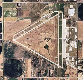
Manhattan Regional Airport in Riley County, Kansas, United States, is the second-busiest commercial airport in Kansas. Owned by the city of Manhattan, Kansas, the airport is located about five miles southwest of downtown Manhattan. American Airlines via its American Eagle affiliate serves the airport with five daily regional jet flights, with two nonstops to Chicago O'Hare International Airport (ORD) and three nonstops to Dallas/Fort Worth International Airport (DFW). The airport also accommodates general aviation and charter flights for the military and college sports teams, being conveniently located four miles east of Fort Riley and eight miles southwest of Kansas State University's athletic complex).

Dodge City Regional Airport is three miles east of Dodge City, in Ford County, Kansas. It is used for general aviation and is subsidized by the Essential Air Service program.
Great Bend Municipal Airport is five miles west of Great Bend, in Barton County, Kansas. It is used for general aviation and formerly saw one airline, subsidized by the Essential Air Service program.
Hays Regional Airport is three miles southeast of Hays, in Ellis County, Kansas, United States. It is used for general aviation and sees one airline, United Express.

Liberal Mid-America Regional Airport is two miles west of Liberal, in Seward County, Kansas. It is used for general aviation and is subsidized by the Essential Air Service program. Formerly Liberal Municipal Airport, it hosts the Mid-America Air Museum.

Salina Regional Airport, formerly Salina Municipal Airport, is located in Salina, Kansas, United States. The airport is owned by the Salina Airport Authority. It is used for general aviation, and has service by one passenger airline, SkyWest Airlines, which is subsidized by the Essential Air Service program.

Drake Field is a public airport three miles south of Fayetteville, in Washington County, Arkansas. It is also known as Fayetteville Executive Airport and was formerly Fayetteville Municipal Airport.

Topeka Regional Airport, formerly known as Forbes Field, is a joint civil-military public airport owned by the Metropolitan Topeka Airport Authority in Shawnee County, Kansas, seven miles south of downtown Topeka, the capital city of Kansas. The National Plan of Integrated Airport Systems for 2011–2015 called it a general aviation airport.
Cessna Aircraft Field is a public use airport located four nautical miles southeast of the central business district of Wichita, in Sedgwick County, Kansas, United States. It is privately owned by the Cessna Aircraft Company.
Goodland Municipal Airport is two miles north of Goodland, in Sherman County, Kansas, United States.

Hutchinson Municipal Airport is a city-owned public airport three miles east of Hutchinson, in Reno County, Kansas, United States.
Tri-City Airport is a public-use airport 12 miles west of Parsons, a city in Labette County, Kansas, United States. It serves Coffeyville, Independence, and Parsons, Kansas.
Newton City-County Airport is three miles east of Newton, in Harvey County, Kansas. It is owned by the City of Newton and Harvey County.

Strother Field is a public airport in Cowley County, Kansas, six miles southwest of Winfield and north of Arkansas City. The airport is jointly owned by the two cities. The National Plan of Integrated Airport Systems for 2011–2015 categorized it as a general aviation facility.
Beech Factory Airport is a public use airport located five nautical miles (9 km) east of the central business district of Wichita, a city in Sedgwick County, Kansas, United States. It is privately owned by Beechcraft.
Atkinson Municipal Airport is three miles northwest of Pittsburg, in Crawford County, Kansas, United States. The National Plan of Integrated Airport Systems for 2011–2015 categorized it as a general aviation facility.
Kirk Field is a city-owned public-use airport located one nautical mile northwest of the central business district of Paragould, in Greene County, Arkansas, United States.
Melbourne Municipal Airport, also known as John E. Miller Field, is a city-owned, public-use airport located three nautical miles (6 km) east of the central business district of Melbourne, a city in Izard County, Arkansas, United States. It is included in the National Plan of Integrated Airport Systems for 2011–2015, which categorized it as a general aviation facility.
Westport Airport is a privately owned, public use airport located three nautical miles (6 km) southwest of the central business district of Wichita, a city in Sedgwick County, Kansas, United States. It is in the Class C airspace of neighboring Wichita Dwight D. Eisenhower National Airport.

