
A lightvessel, or lightship, is a ship that acts as a lighthouse. They are used in waters that are too deep or otherwise unsuitable for lighthouse construction. Although some records exist of fire beacons being placed on ships in Roman times, the first modern lightvessel was off the Nore sandbank at the mouth of the River Thames in England, placed there by its inventor Robert Hamblin in 1734. The type has become largely obsolete; lighthouses replaced some stations as the construction techniques for lighthouses advanced, while large, automated buoys replaced others.
Leading lights are a pair of light beacons used in navigation to indicate a safe passage for vessels entering a shallow or dangerous channel; they may also be used for position fixing. At night, the lights are a form of leading line that can be used for safe navigation. The beacons consist of two lights that are separated in distance and elevation, so that when they are aligned, with one above the other, they provide a bearing. Range lights are often illuminated day and night.

Cape Hatteras Light is a lighthouse located on Hatteras Island in the Outer Banks in the town of Buxton, North Carolina and is part of the Cape Hatteras National Seashore. The lighthouse’s semi-unique pattern makes it easy to recognize and famous. It is often ranked high on lists of most beautiful, and famous lighthouses in the US.

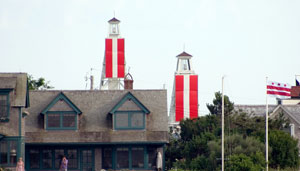
The Charlevoix South Pier Light Station is located on Lake Michigan at the entrance to Lake Charlevoix in Charlevoix County in the U.S. state of Michigan at the end of the south pier/breakwater of the channel leading to Round Lake in the city of Charlevoix.

The Cape Canaveral Light is a historic lighthouse on the east coast of the U.S. state of Florida. The light was established in 1848 to warn ships of the dangerous shoals that lie off its coast. It is located inside the Cape Canaveral Space Force Station and managed by the Space Launch Delta 45 of the U.S. Space Force with the assistance of the Cape Canaveral Lighthouse Foundation. It is the only fully operational lighthouse that is owned by the United States Space Force.

There have been at least four lighthouses named Chennai Lighthouse or Madras Lighthouse, which face the Bay of Bengal on the east coast of the Indian Subcontinent in Chennai, India.

Marjaniemi Lighthouse is a lighthouse located in the village of Marjaniemi at the westernmost point of Hailuoto island on the Gulf of Bothnia. The lighthouse is located approximately 50 kilometres (31 mi) west of Oulu. The lighthouse was designed by Axel Hampus Dalström as his fourth lighthouse and it was first lit in 1872.

Laitakari beacon tower is a daymark located on the island of Laitakari in the Gulf of Bothnia in Finland. The island is located east-northeast of Hailuoto and is within the municipal boundaries of the City of Oulu. There has been a navigational aid on the island since the 1750s, and a beacon tower has been marked on a chart dated in 1785.

Koskela Light is a sector light tower located on the southern shore of Letonniemi promontory in Taskila district of the City of Oulu in Finland. The tower is located within the boundaries of the Letonniemi natural preserve.

Bull Point Lighthouse is a lighthouse on Bull Point, about one mile (1.6 km) north of the village of Mortehoe, on the northern coast of Devon, England. The lighthouse provides a visual aid to the villages of Mortehoe, Woolacombe and Ilfracombe, and warns of the inhospitable and rocky coast that lines the area.

Winterton Lighthouse is located in Winterton-on-Sea in the English county of Norfolk. In 1845 Winterton Ness was described as being 'well known to the mariner as the most fatal headland between Scotland and London'. As well as marking the headland, the lighthouse was intended to help guide vessels into the Cockle Gat, which provided the northern entry into the safe water of Yarmouth Roads. The lighthouse was known to Daniel Defoe and is mentioned in his novel Robinson Crusoe.

Hospital Point Range Front Light is a historic lighthouse at the end of Bayview Avenue in Beverly, Massachusetts. It forms the front half of a range which guides vessels toward Salem Harbor. The tower was added to the National Register of Historic Places as Hospital Point Light Station on September 28, 1987.

Hurst Point Lighthouse is located at Hurst Point in the English county of Hampshire, and guides vessels through the western approaches to the Solent.
The High lighthouse or pillar lighthouse is one of three lighthouses in Burnham-on-Sea, Somerset, England. A Grade II listed building, it is no longer functional as a lighthouse and has been converted for use as a private dwelling.

The Low Lighthouse is one of three historic lighthouses in Burnham-on-Sea, Somerset, England, and the only one of the three which is still active. It is a Grade II listed building and stands on the foreshore. First lit in 1832, the Low Lighthouse operated in conjunction with the (onshore) High Lighthouse for 137 years. Then, in 1969 the Low Lighthouse was deactivated; but later, in 1993, the Low Lighthouse was re-established and the High Lighthouse was instead decommissioned).

The Needles Lighthouse is an active 19th century lighthouse on the outermost of the chalk rocks at The Needles on the Isle of Wight in the United Kingdom, near sea level. Designed by James Walker, for Trinity House at a cost of £20,000. It was completed in 1859 from granite blocks, stands 33.25 metres (109.1 ft) high and is a circular tower with straight sides. It replaced an earlier light tower on top of a cliff overhanging Scratchell's Bay, which was first lit on 29 September 1786.
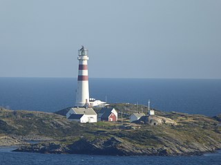
Oksøy Lighthouse is a coastal lighthouse in the municipality of Kristiansand in Agder county, Norway. The lighthouse sits on the islet of Oksøy which is located in the Kristiansandsfjorden, just east of the island of Flekkerøya. The lighthouse marks the western side of the main shipping channel that leads inland to the port of the city of Kristiansand. The other lighthouse, which marks the eastern entrance, Grønningen Lighthouse, lies about 2.2 kilometres (1.4 mi) to the east. The lighthouse has a racon signal, emitting a morse code "O".

Lowestoft Lighthouse is a lighthouse operated by Trinity House located to the north of the centre of Lowestoft in the English county of Suffolk. It stands on the North Sea coast close to Ness Point, the most easterly point in the United Kingdom. It acts as a warning light for shipping passing along the east coast and is the most easterly lighthouse in the UK.

The Pass A L'Outre Light is a defunct lighthouse in the Birdfoot Delta in Louisiana, United States, located near the mouth of the Mississippi River. Erected to mark the then-active entrance to the river, it was abandoned as that channel silted up. It has been in the path of several noteworthy hurricanes, and was heavily damaged. It is on the Lighthouse Digest Doomsday List, and is critically in danger. The lighthouse is at the center of a nature preserve.

The Inisheer, Inis Oírr or Fardurris Point Lighthouse, is an active 19th century lighthouse located on the island of Inisheer, the smallest of the Aran Islands, in County Galway, Ireland. It marks the south-eastern entrance to Galway bay and the port of Galway known as the South Sound, with a red sector of the light marking the Finnis Rock. The Eeragh Lighthouse which marks the North Sound entrance to the bay on the north-western side of the islands, was also constructed at the same time. Inisheer and Eeragh both became operational in 1857.

