Haukipudas

Last updated
Haukipudas
Municipality
Haukiputaan kunta
Haukipudas kommun
Haukipudas-Church Bellfry 2006 04 30.JPG
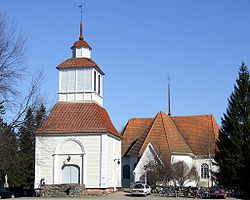
The church and the belfry of Haukipudas
Haukipudas.vaakuna.svg
Haukipudas.sijainti.suomi.2008.svg
Location of Haukipudas in Finland
Coordinates: 65°11′N025°21′E / 65.183°N 25.350°E / 65.183; 25.350
Country Finland
Region Northern Ostrobothnia
Sub-region Oulu sub-region
Charter 1866
Government
  Municipality manager Jarmo Ronkainen
Area
[1]
  Total1,023.62 km2 (395.22 sq mi)
  Land798.67 km2 (308.37 sq mi)
  Water224.95 km2 (86.85 sq mi)
Population
 (2012) [2]
  Total19,053
  Density19/km2 (48/sq mi)
Time zone UTC+2 (EET)
  Summer (DST) UTC+3 (EEST)
Website www.haukipudas.fi

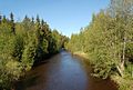
Haukipudas is a town and former municipality of Finland. It was located in the province of Oulu and is part of the Northern Ostrobothnia region. Its shore runs along the Gulf of Bothnia, with the river Kiiminkijoki running through the province. Along with Kiiminki, Oulunsalo and Yli-Ii municipalities it was merged with the city of Oulu on 1 January 2013.

Contents

The municipality had a population of 19,053 (31 December 2012) [2] and covered an area of 1,023.62 km2 (395.22 sq mi) of which 224.95 km2 (86.85 sq mi) is water. [1] The population density is

The municipality was unilingually Finnish. [3]

There were 16 villages in Haukipudas: Kirkonkylä, Santaholma, Ukonkaivos, Martinniemi, Asemakylä, Onkamo, Halosenniemi, Holstinmäki, Häyrysenniemi, Jokikylä, Kalimeenkylä, Kello, Kiviniemi, Parkumäki, Takkuranta and Virpiniemi.

The educational department took part in Lifelong Learning Programme 2007–2013 in Finland.

Local sights

Islands located off the Gulf of Bothnia

The following is a compilation of some of the islands of Haukipudas located just off the coast of the Gulf of Bothnia:

Hanhikari, Hietakari, Hoikka-Hiue, Iso-Hiue, Iso-Miehikkä, Isonkivenletto, Kaasamatala (Hiuvet), Kattilankalla, Kellon Kraaseli, Kintasletto, Kotakari, Kriisinkivi, Kropsu, Laitakari, Lemmonletto, Länsiletto, Lönkytin, Mustakari, Mustakari (Martinniemi), Nimetön, Pallonen, Pensaskari, Pikku-Miehikkä, Pulkkisenmatala, Puukkoletto, Rapakari, Rivinletto (Kaasamatala), Santapankki, Satakarinletto, Ulko-Pallonen, Välikari, Ykskivi, Väliletto, Äijänkumpele.

Notable individuals

Related Research Articles

<span class="mw-page-title-main">Kokkola</span> Town in Central Ostrobothnia, Finland

Kokkola is a town in Finland and the regional capital of Central Ostrobothnia. It is located on the west coast of the country, on the Gulf of Bothnia. The population of Kokkola is approximately 48,000, while the sub-region has a population of approximately 54,000. It is the 22nd most populous municipality in Finland, and the 20th most populous urban area in the country.

<span class="mw-page-title-main">Oulu</span> City in North Ostrobothnia, Finland

Oulu is a city in Finland and the regional capital of North Ostrobothnia. It is located on the northwestern coast of the country at the mouth of the River Oulu. The population of Oulu is approximately 215,000, while the sub-region has a population of approximately 263,000. It is the 5th most populous municipality in Finland, and the fourth most populous urban area in the country. Oulu is also the most populous city in Northern Finland.

<span class="mw-page-title-main">Simo, Finland</span> Municipality in Lapland, Finland

Simo is a municipality located in the province of Lapland, Finland, about 50 kilometres (30 mi) from the Swedish border.

<span class="mw-page-title-main">Jakobstad</span> Town in Ostrobothnia, Finland

Jakobstad is a town in Finland, located on the west coast of the country. Jakobstad is situated in Ostrobothnia, along the Gulf of Bothnia. The population of Jakobstad is approximately 19,000, while the sub-region has a population of approximately 50,000. It is the 60th most populous municipality in Finland.

<span class="mw-page-title-main">Ii, Finland</span> Municipality in Northern Ostrobothnia, Finland

Ii is a municipality of Finland. It is situated by the Bothnian Bay, at the mouth of river Iijoki, and it is part of the Northern Ostrobothnia region. The municipality has a population of 9,768 and covers an area of 2,872.44 km2 (1,109.06 sq mi) of which 1,256.69 km2 (485.21 sq mi) is water. The population density is 6.05/km2 (15.7/sq mi).

<span class="mw-page-title-main">Ylöjärvi</span> Town in Pirkanmaa, Finland

Ylöjärvi is a town in Finland, located in the Pirkanmaa region. It lies to the west of the regional capital, Tampere. The population of Ylöjärvi is approximately 34,000, while the metropolitan area has a population of approximately 417,000. It is the 34th most populous municipality in Finland, and the third largest in the Pirkanmaa region after Tampere and Nokia.

<span class="mw-page-title-main">Oulunsalo</span> Former municipality in Northern Ostrobothnia, Finland

Oulunsalo is former municipality in the region of Northern Ostrobothnia, in Finland. It was founded in 1882 and merged into the city of Oulu on 1 January 2013, along with Haukipudas, Kiiminki and Yli-Ii. The municipality had a population of 9,746 and covered an area of 211.22 square kilometres (81.55 sq mi), of which 127.86 km2 (49.37 sq mi) is water. Its population density is 116.915/km2 (302.81/sq mi).

<span class="mw-page-title-main">Hailuoto</span> Municipality in North Ostrobothnia, Finland

Hailuoto is a Finnish island in the northern Baltic Sea and a municipality in Northern Ostrobothnia region. The population of Hailuoto is 948, making it the smallest municipality in Northern Ostrobothnia and the former Oulu Province in terms of population. The municipality covers an area of 205.65 km2 (79.40 sq mi) of which 1.70 km2 (0.66 sq mi) is inland water. The population density is 4.61/km2 (11.9/sq mi). Of all the Finnish sea islands, Hailuoto is the third largest after Fasta Åland and Kimitoön.

<span class="mw-page-title-main">Kalajoki</span> Town in North Ostrobothnia, Finland

Kalajoki is a coastal town and municipality of Finland. It is located in the immediate vicinity of the Gulf of Bothnia in the province of Oulu and is part of the Northern Ostrobothnia region.

<span class="mw-page-title-main">Kiiminki</span> Former municipality in Northern Ostrobothnia, Finland

Kiiminki was a municipality of Finland. Along with Haukipudas, Oulunsalo and Yli-Ii municipalities it was merged with the city of Oulu on 1 January 2013. Kiiminki municipality was part of the Oulu province in the Northern Ostrobothnia region. The municipality had a population of 13,320 and covered an area of 339.00 square kilometres (130.89 sq mi) of which 326.82 km2 (126.19 sq mi) is water. The population density is 1,093.6/km2 (2,832.4/sq mi).

<span class="mw-page-title-main">Kuusamo</span> Town and municipality in North Ostrobothnia, Finland

Kuusamo is a town and municipality in Finland. It is located in Koillismaa, the northeastern part of the Northern Ostrobothnia region. The municipality has a population of 15,017 and covers an area of 5,808.92 square kilometres (2,242.84 sq mi) of which 830.81 km2 (320.78 sq mi) is water. The population density is 3.02 inhabitants per square kilometre (7.8/sq mi).

<span class="mw-page-title-main">Riihimäki</span> Town in Tavastia Proper, Finland

Riihimäki is a town and municipality in the south of Finland, about 69 kilometres (43 mi) north of Helsinki and 109 kilometres southeast of Tampere. An important railway junction is located in Riihimäki, since railway tracks from Riihimäki lead to Helsinki, Tampere and Lahti. Several businesses also operate in Riihimäki. Notably, Würth Oy has its Finnish headquarters and logistics center in Riihimäki. Valio has a major dairy in the Herajoki part of Riihimäki. The famous Sako rifles are also produced in Riihimäki. Riihimäki also has the second-highest flagpole in Finland.

<span class="mw-page-title-main">Yli-Ii</span> Former municipality in Northern Ostrobothnia, Finland

Yli-Ii was a municipality of Finland. It was located in the province of Oulu and was part of the Northern Ostrobothnia region. Alongside Haukipudas, Kiiminki and Oulunsalo municipalities it was merged with the city of Oulu on 1 January 2013. The municipality had a population of 2,179 and covered an area of 793.27 square kilometres (306.28 sq mi) of which 24.12 km2 (9.31 sq mi) is water. The population density was 2.8330/km2 (7.3374/sq mi).

<span class="mw-page-title-main">Ylikiiminki</span> Former municipality in Northern Ostrobothnia, Finland

Ylikiiminki is a former municipality of Finland. It was consolidated with the city of Oulu on 1 January 2009.

<span class="mw-page-title-main">Bothnian Bay</span> Bay in the northern Bothnian Sea

The Bothnian Bay or Bay of Bothnia is the northernmost part of the Gulf of Bothnia, which is in turn the northern part of the Baltic Sea. The land holding the bay is still rising after the weight of ice-age glaciers has been removed, and within 2,000 years the bay will be a large freshwater lake since its link to the south Kvarken is mostly less than 20 metres (66 ft) deep. The bay today is fed by several large rivers, and is relatively unaffected by tides, so has low salinity. It freezes over each year for up to six months. Compared to other parts of the Baltic, it has little plant or animal life.

<span class="mw-page-title-main">Vaasa</span> City in Ostrobothnia, Finland

Vaasa, in the years 1855–1917 as Nikolainkaupunki, is a city in Finland and the regional capital of Ostrobothnia. It is located on the west coast of the country, on the Gulf of Bothnia. The population of Vaasa is approximately 69,000, while the sub-region has a population of approximately 110,000. It is the 14th most populous municipality in Finland, and the tenth most populous urban area in the country.

<span class="mw-page-title-main">Kiiminki (district)</span> District of Oulu in Finland

Kiiminki is a district of Oulu, Finland. Together with Alakylä, Hannus and Huttukylä districts, it forms the Kiiminki area. The center of the district is located where the National road 20 crosses the Kiiminkijoki river. The district was established in 2013 when the Kiiminki municipality together with Haukipudas, Oulunsalo and Yli-Ii municipalities were merged with the city of Oulu.

<span class="mw-page-title-main">Oulujoki (municipality)</span> Former municipality in Oulu Province, Finland

Oulujoki is a former municipality of Finland. The municipality had a population of 5,230 (1963) and covered a land area of 606.1 square kilometres (234.0 sq mi). Its neighbouring municipalities were Kempele, Kiiminki, Muhos, Oulu, Tyrnävä, Utajärvi and Ylikiiminki. The municipality was named after the river Oulujoki.

References

  1. 1 2 "Area by municipality as of 1 January 2011" (PDF) (in Finnish and Swedish). Land Survey of Finland. Retrieved 9 March 2011.
  2. 1 2 "VÄESTÖTIETOJÄRJESTELMÄ REKISTERITILANNE 31.1.2012" (in Finnish and Swedish). Population Register Center of Finland. Archived from the original on 3 October 2013. Retrieved 11 February 2014.
  3. "Population according to language and the number of foreigners and land area km2 by area as of 31 December 2008". Statistics Finland's PX-Web databases. Statistics Finland. Retrieved 29 March 2009.[ permanent dead link ]
  4. "Muslim Council head condemns extremism". www.thelocal.se. Retrieved 2021-02-18.