Paavola

Last updated
Paavola
Former municipality
Paavolan kunta
Paavola kommun
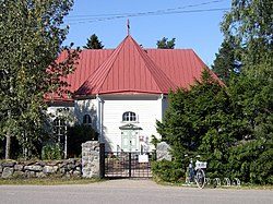
Paavola Church 2006 07 27.JPG
Paavola Church
Paavola.vaakuna.svg
Paavola.sijainti.suomi.svg
Location of Paavola in Finland
Coordinates: 64°36′30″N025°12′20″E / 64.60833°N 25.20556°E / 64.60833; 25.20556
Country Finland
Region Northern Ostrobothnia
Established1874
Consolidated1973
Area
[1]
  Land565.8 km2 (218.5 sq mi)
Population
 (1970) [1]
  Total4,568
Time zone UTC+2 (EET)
  Summer (DST) UTC+3 (EEST)

Paavola is a former municipality of Finland, now a village in the municipality of Siikajoki. The village is located beside the Siikajoki river. Though lacking rail transport connections, the settlement does lie beside the crossroads of routes 86 and 807.

Contents

In 1973, Paavola was consolidated with the neighboring municipality of Revonlahti to form the municipality of Ruukki. Ruukki in turn was consolidated with Siikajoki in 2007.

Geography

The municipality of Paavola bordered Revonlahti, Liminka, Rantsila, Vihanti and Pattijoki.

Villages

[2]

History

The name of Paavola is derived from the name of Paavo Laurinpoika, who established a farm in the area in the 1550s. Paavola was a part of the Siikajoki parish, becoming a chapel community in 1811 and a separate parish in 1874. [3] [2]

Paavola and Revonlahti united in 1973 to form Ruukki, which was consolidated with Siikajoki in 2007.

Related Research Articles

<span class="mw-page-title-main">Nokia, Finland</span> Town in Pirkanmaa, Finland

Nokia is a town and municipality in southwestern Finland. It lies on the banks of the Nokianvirta River in the region of Pirkanmaa, about 15 kilometres (9 mi) west of Tampere. The distance to Tampere Airport from Nokia is 16 kilometres (9.9 mi) using road connections when circling Lake Pyhäjärvi. Its neighboring municipalities are Hämeenkyrö, Pirkkala, Sastamala, Tampere, Vesilahti and Ylöjärvi. As of 28 February 2023 it has a population of 35,335 and it is one of the fastest-growing cities in the area; today, Nokia is the 33rd largest municipality of Finland by population and the second largest municipality in Pirkanmaa after Tampere.

<span class="mw-page-title-main">Kodisjoki</span> Former municipality of southwest Finland

Kodisjoki is a village and a former municipality of Finland. At the time of the municipality's disestablishment, Kodisjoki was located in the province of Western Finland, now it is in the Satakunta region. Kodisjoki became part of the city of Rauma in 2007.

<span class="mw-page-title-main">Hämeenkoski</span> Former municipality in Päijänne Tavastia, Finland

Hämeenkoski is a former municipality of Finland. It was merged to the municipality of Hollola on 1 January 2016.

<span class="mw-page-title-main">Kärsämäki</span> Municipality in North Ostrobothnia, Finland

Kärsämäki is a municipality of Finland. It is located in the province of Oulu and is part of the Northern Ostrobothnia region. The municipality has a population of 2,467 and covers an area of 700.91 square kilometres (270.62 sq mi) of which 6.06 km2 (2.34 sq mi) is water. The population density is 3.55 inhabitants per square kilometre (9.2/sq mi). Kärsämäki is a significant road junction where Highway 4 (Helsinki–Oulu–Utsjoki) and Highway 28 (Kokkola–Kajaani) intersect and where Highway 58 leading to Kangasala begins. The distance to the regional capital Oulu is 123 kilometres (76 mi).

<span class="mw-page-title-main">Piippola</span> Place in Northern Ostrobothnia, Finland

Piippola is a village and a former municipality of Finland.

<span class="mw-page-title-main">Ruukki</span> Former municipality in Northern Ostrobothnia, Finland

Ruukki is a former municipality of Finland.

<span class="mw-page-title-main">Siikajoki</span> Municipality in North Ostrobothnia, Finland

Siikajoki is a municipality of Finland. It is part of the North Ostrobothnia region. The municipality has a population of 4,895 (28 February 2023) and covers an area of 1,653.89 square kilometres (638.57 sq mi) of which 601.94 km2 (232.41 sq mi) is water. The population density is 4.65 inhabitants per square kilometre (12.0/sq mi). Neighbour municipalities are Hailuoto, Liminka, Lumijoki, Raahe and Siikalatva.

<span class="mw-page-title-main">Karhula</span> Former municipality in Kymi Province, Finland

Karhula is a former market town (kauppala) and a former municipality of Finland in the former Kymi Province, now in the Kymenlaakso region. It was consolidated with the town of Kotka in 1977. Its seat was in Helilä, however the municipality was named after the industrial area of Karhula.

<span class="mw-page-title-main">Björköby</span> Former municipality in Vaasa Province, Finland

Björköby is a village and a former municipality now part of Korsholm, Finland. It is the chief settlement on the island of Björkö. The harbour of the village is called Svedjehamn.

<span class="mw-page-title-main">Pörtom</span> Former municipality in Vaasa Province, Finland

Pörtom is a former municipality in Ostrobothnia, Finland. The municipality was consolidated with Närpes in 1973. North Pörtom, however, was transferred to Malax in 1975.

<span class="mw-page-title-main">Oulu Province</span>

The Province of Oulu was a province of Finland from 1775 to 2009. It bordered the provinces of Lapland, Western Finland and Eastern Finland and also the Gulf of Bothnia and Russia.

<span class="mw-page-title-main">Kuusisto (island)</span> Island and former municipality in the country of Finland

Kuusisto is an island and former municipality in Kaarina, Finland. The island is about 12 km long and 2 km wide. Its main attraction is Kuusisto Castle.

<span class="mw-page-title-main">Äänekosken maalaiskunta</span> Former municipality in Central Finland, Finland

Äänekosken maalaiskunta is a former municipality of Finland in the Central Finland region. It was consolidated with the kauppala of Äänekoski in 1969.

<span class="mw-page-title-main">Pattijoki</span> Former municipality in Oulu Province, Finland

Pattijoki is a settlement and former municipality in Finland. It was a part of the Oulu Province, but now located in the region of Northern Ostrobothnia. It was consolidated with the town of Raahe in 2003.

<span class="mw-page-title-main">Saloinen</span> Former municipality in Oulu Province, Finland

Saloinen is a former municipality of Finland. It was a part of the Oulu Province, but now located in the region of Northern Ostrobothnia. It was consolidated with the town of Raahe in 1973.

<span class="mw-page-title-main">Karjala, Finland</span> Former municipality in Turku and Pori Province, Finland

Karjala is a former municipality of Finland in the former Turku and Pori Province, now in Finland Proper. It was consolidated with Mynämäki in 1977.

<span class="mw-page-title-main">Haapasaari (Kotka)</span> Former municipality in Kymi Province, Finland

Haapasaari is an island and a former municipality of Finland in the former Kymi Province, now in the Kymenlaakso region. It was consolidated with the town of Kotka in 1974.

<span class="mw-page-title-main">Lokalahti</span> Former municipality in Turku and Pori Province, Finland

Lokalahti is a village and a former municipality of Finland in the former Turku and Pori Province, now in the Finland Proper region. It was consolidated with the town of Uusikaupunki in 1981.

<span class="mw-page-title-main">Pyhämaa</span> Former municipality in Turku and Pori Province, Finland

Pyhämaa is a village and a former municipality of Finland in the former Turku and Pori Province, now in the Finland Proper region. It was consolidated with the town of Uusikaupunki in 1974.

References

  1. 1 2 "Suomen kunnat: Paavola" (in Finnish). Retrieved 1 April 2010.
  2. 1 2 "Suomen Sukututkimusseura". hiski.genealogia.fi (in Finnish). Retrieved January 7, 2023.
  3. "SuomalainenPaikannimikirja_e-kirja_kuvallinen.pdf" (PDF). kaino.kotus.fi (in Finnish). p. 314. Retrieved January 7, 2023.

Commons-logo.svg Media related to Paavola at Wikimedia Commons