
The Mullica River is a 50.6-mile-long (81.4 km) river in southern New Jersey in the United States. The Mullica was once known as the Little Egg Harbor River.

The Tuckahoe River is a 27.6-mile-long (44.4 km) blackwater river in southern New Jersey in the United States.
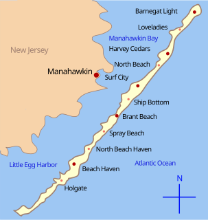
Little Egg Harbor is a brackish bay along the coast of southeast New Jersey. It was originally called Egg Harbor by the Dutch sailors because of the eggs found in nearby gull nests.
Nescochague Creek is a 6.4-mile-long (10.3 km) tributary of the Mullica River in southern New Jersey in the United States. The creek starts just northwest of Hammonton, arcs along the southern boundary of Wharton State Forest, and joins the Mullica River just above County Route 542.
The South Branch Rancocas Creek is a 21.7-mile-long (34.9 km) tributary of Rancocas Creek in Burlington County, New Jersey in the United States. The South Branch Rancocas Creek drains an area of 144 square miles. Much of the upland agriculture within the Rancocas Creek basin lies inside the South Branch Rancocas Creek basin. It is also among the least developed parts of the Rancocas Creek watershed.
The Southwest Branch Rancocas Creek is a 13.8-mile-long (22.2 km) tributary of the South Branch Rancocas Creek in Burlington County, New Jersey in the United States.
The North Branch Rancocas Creek is a 31-mile-long (50 km) tributary of Rancocas Creek in southwestern New Jersey in the United States.
English Creek is a 6.0-mile-long (9.7 km) tributary of the Great Egg Harbor River in southeast New Jersey in the United States.
Tulpehocken Creek is a 7.7-mile-long (12.4 km) tributary of the Wading River in Burlington County in the southern New Jersey Pine Barrens in the United States.
Oyster Creek is a 10.4-mile-long (16.7 km) tributary of Barnegat Bay in southeastern New Jersey in the United States.

Wawayanda Creek is the name of Pochuck Creek above its confluence with the tributary Black Creek.
Pochuck Creek is an 8.1-mile-long (13.0 km) tributary of the Wallkill River in Orange County, New York and Sussex County, New Jersey, in the United States.

Green Creek is an unincorporated community located within Middle Township, in Cape May County, New Jersey, United States. It is located on Route 47. It is a very low-lying area with a highest elevation of just above 20 feet (6.1 m). The community is located about 3 miles (4.8 km) west of Rio Grande and about 2 miles (3.2 km) from the Delaware Bay. It is mostly residential with areas of agriculture and commerce along the main road, Delsea Drive. The United States Postal Service ZIP Code is 08219.
Pleasure Bay is a tributary of the Shrewsbury River in Monmouth County, New Jersey in the United States.

South Dennis is an unincorporated community located within Dennis Township in Cape May County, New Jersey, United States. It is part of the Ocean City Metropolitan Statistical Area. Its postal ZIP Code is 08245.
The Forked River Nuclear Power Plant was a proposed nuclear power plant in Lacey Township in Ocean County, New Jersey. It was proposed as a single 1,070 MW reactor in 1969 to be built by Combustion Engineering and operated by Jersey Central Power and Light. The facility would have been located on a site between JCP&L's existing Oyster Creek Nuclear Generating Station and the Garden State Parkway. Unlike the Oyster Creek Plant, the Forked River Plant would have a cooling tower to prevent the release of hot water into Oyster Creek and Barnegat Bay.

Jessie Creek Winery is a winery in the Dias Creek section of Middle Township in Cape May County, New Jersey. The vineyard was first planted in 2002, and opened to the public in 2012. Jessie Creek has 5 acres of grapes under cultivation, and produces 1,200 cases of wine per year. The winery's name is an amalgamation of Jessie, the name of the former owner's mother, and Dias Creek.
West Branch Papakating Creek is a tributary of Papakating Creek located in Frankford and Wantage townships in Sussex County, New Jersey, in the United States.
Little Creek is a 12.58 mile long river in Burlington County, New Jersey. It drains into the Southwest Branch Rancocas Creek. Little Creek itself drains an area of 6.32 square miles. Little Creek has been found to be impaired for primary recreation, but safe and suitable for aquatic life. Little Creek drains mostly a suburban/rural area, and has been classified as a low-gradient stream.

