East Creek (New Jersey)

Last updated

East Creek is a 4.8-mile-long (7.7 km) [1] tributary of Delaware Bay in Cape May County, New Jersey in the United States. [2]

Tributary stream or river that flows into a main stem river or lake

A tributary or affluent is a stream or river that flows into a larger stream or main stem river or a lake. A tributary does not flow directly into a sea or ocean. Tributaries and the main stem river drain the surrounding drainage basin of its surface water and groundwater, leading the water out into an ocean.

Delaware Bay The estuary outlet of the Delaware River on the Northeast seaboard of the United States

Delaware Bay is the estuary outlet of the Delaware River on the Northeast seaboard of the United States. Approximately 782 square miles (2,030 km2) in area, the bay's fresh water mixes for many miles with the salt water of the Atlantic Ocean.

Cape May County, New Jersey County in the United States

Cape May County is the southernmost county in the U.S. state of New Jersey. Much of the county is located on the Cape May Peninsula, bounded by the Delaware Bay to the west, and the Atlantic Ocean to the south and east. Adjacent to the Atlantic coastline are five barrier islands that have been built up as seaside resorts. A consistently popular summer destination with 30 miles (48 km) of beaches, Cape May County attracts vacationers from New Jersey and surrounding states, with the summer population exceeding 750,000. Tourism generates annual revenues of about $6 billion as of 2015, making it the county's single largest industry, with leisure and hospitality being Cape May's largest employment category. Its county seat is the Cape May Court House section of Middle Township.

Contents

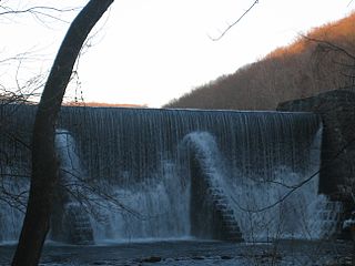
It is probably named in contradistinction to West Creek, which lies to the west, although the name of that creek is ultimately derived from the Lenape "westeconk". It rises in Belleplain State Forest, and is dammed to form East Creek Pond, which covers its convergence with Savages Run. It flows through the tidal marshes on the east side of the Stipson Island peninsula, where it is joined by Willis Run. Just below, most of its flow is diverted by Roaring Ditch into Dennis Creek, leaving only a small channel to reach the bay.

West Creek is a 12.3-mile-long (19.8 km) tributary of Delaware Bay in Cape May County, New Jersey in the United States.

Belleplain State Forest

Belleplain State Forest is a 21,320-acre (86.3 km2) New Jersey State Forest in northern Cape May County and eastern Cumberland County. It has many young pine, oak and Atlantic white cedar trees, having better soil than the northern Pine Barrens. It was established in 1928 and the Civilian Conservation Corps (CCC) set up camps here in 1933, converted Meisle Cranberry Bog into Lake Nummy and constructing the original forest headquarters, maintenance building, a road system, bridges, and dams.

Roaring Ditch is a tidal waterway approximately 1.6 mi (2.6 km) in length connecting East Creek and Dennis Creek in Cape May County, New Jersey in the United States.

Tributaries

See also

Related Research Articles

Overpeck Creek is a tributary of the Hackensack River, approximately 8 miles (13 km) long, in Bergen County in northeastern New Jersey in the United States. The lower broad mouth of the creek is part of the extended tidal estuary of the lower Hackensack and of the adjacent wetland region known as the New Jersey Meadowlands.

Mullica River river in the United States of America

The Mullica River is a 50.6-mile-long (81.4 km) river in southern New Jersey in the United States. The Mullica was once known as the Little Egg Harbor River.

Crosswicks Creek is a 25.3-mile-long (40.7 km) tributary of the Delaware River in Burlington County, New Jersey in the United States.

South Branch Raritan River river in the United States of America

The South Branch Raritan River is a 50-mile-long (80 km) tributary of the Raritan River in central New Jersey in the United States.

The North Branch Raritan River is a tributary of the Raritan River in central New Jersey in the United States.

Dennis Creek is an 8.8-mile-long (14.2 km) tributary of Delaware Bay in Cape May County, New Jersey in the United States.

Sluice Creek is a 5.3-mile-long (8.5 km) tributary of Dennis Creek in Cape May County, New Jersey in the United States.

Stony Brook (Millstone River tributary) tributary of the Millstone River in Mercer County, New Jersey

Stony Brook, also known as Stoney Brook, is a tributary of the Millstone River in Hunterdon and Mercer counties, New Jersey, in the United States.

Millstone River river in New Jersey, United States

The Millstone River is a 38.6-mile-long (62.1 km) tributary of the Raritan River in central New Jersey in the United States.

Larrys Creek tributary of the West Branch Susquehanna River

Larrys Creek is a 22.9-mile-long (36.9 km) tributary of the West Branch Susquehanna River in Lycoming County in the U.S. state of Pennsylvania. A part of the Chesapeake Bay drainage basin, its watershed drains 89.1 square miles (231 km2) in six townships and a borough. The creek flows south from the dissected Allegheny Plateau to the Ridge-and-valley Appalachians through sandstone, limestone, and shale from the Devonian, Mississippian, and Pennsylvanian periods.

Frankstown Branch Juniata River river in the United States of America

The Frankstown Branch Juniata River is a 46.0-mile-long (74.0 km) tributary of the Juniata River in Blair and Huntingdon Counties, Pennsylvania, in the United States.

Mount Pleasant, Burlington County, New Jersey historic community in Burlington County, New Jersey

Mount Pleasant is a historic community located within the southeastern range of Mansfield Township and the northeastern range of Springfield Township, Burlington County, New Jersey. Mount Pleasant encompasses the intersection of Mount Pleasant Road and Gaunt's Bridge Road, 40°3′56″N74°40′4″W. The intersection is located about three miles (5 km) east of Columbus and one mile (1.7 km) south of Georgetown.

Hackensack RiverWalk a is partially constructed greenway along the Newark Bay and Hackensack River on the west side of the Bergen Neck peninsula in Hudson County, New Jersey. The eight-mile walkway, following the contour of the water's edge, will run between the southern tip at Bergen Point, where it may connect to the Hudson River Waterfront Walkway, and Eastern Brackish Marsh in the north. Existing parks and promenades have been incorporated and some new sections have been built, but there remain large gaps. There is a RiverWalk in the city of Hackensack, sometimes called the Hackensack RiverWalk, but they are not part of the same project nor are they connected. A parallel walkway on the west banks of the river is known as the Meadow Path.

Great Ditch

Great Ditch is a drainage ditch that drains areas of the Pigeon Swamp State Park in New Jersey in the United States.

Cruser Brook

Cruser Brook, also known as Crusers Brook, is a tributary of Pike Run in Somerset County, New Jersey in the United States.

Baldwins Creek river in the United States of America

Baldwins Creek is a tributary of the Stony Brook in Mercer County, New Jersey in the United States.

Timber Run river in the United States of America

Timber Run is a tributary of Rocky Brook in Mercer County, New Jersey in the United States.

References

  1. U.S. Geological Survey. National Hydrography Dataset high-resolution flowline data. The National Map Archived 2012-04-05 at WebCite , accessed April 1, 2011
  2. Gertler, Edward. Garden State Canoeing, Seneca Press, 2002. ISBN   0-9605908-8-9

Coordinates: 40°32′50″N74°39′08″W / 40.547200°N 74.652100°W / 40.547200; -74.652100

Geographic coordinate system Coordinate system

A geographic coordinate system is a coordinate system that enables every location on Earth to be specified by a set of numbers, letters or symbols. The coordinates are often chosen such that one of the numbers represents a vertical position and two or three of the numbers represent a horizontal position; alternatively, a geographic position may be expressed in a combined three-dimensional Cartesian vector. A common choice of coordinates is latitude, longitude and elevation. To specify a location on a plane requires a map projection.